
Expanding the Port Everglades: Real-Time Monitoring of Water Quality Conditions from Planned Dredging Operation
The Port Everglades in Broward County, Florida, serves large trade vessels and cruiseliners and incoming and outgoing recreational boaters. However, as cargo ships become larger, the port must expand.
A dredging project led by the US Army Corps of Engineers will substantially deepen and widen the port’s navigation channel to accommodate larger Panamax cargo ships and modern cruise liners.
As a result of this project, a large amount of sediment will be displaced into the water column. This suspended sediment may settle outside of the project area, burying benthic organisms like corals, and possibly carrying harmful particulates to other regions.
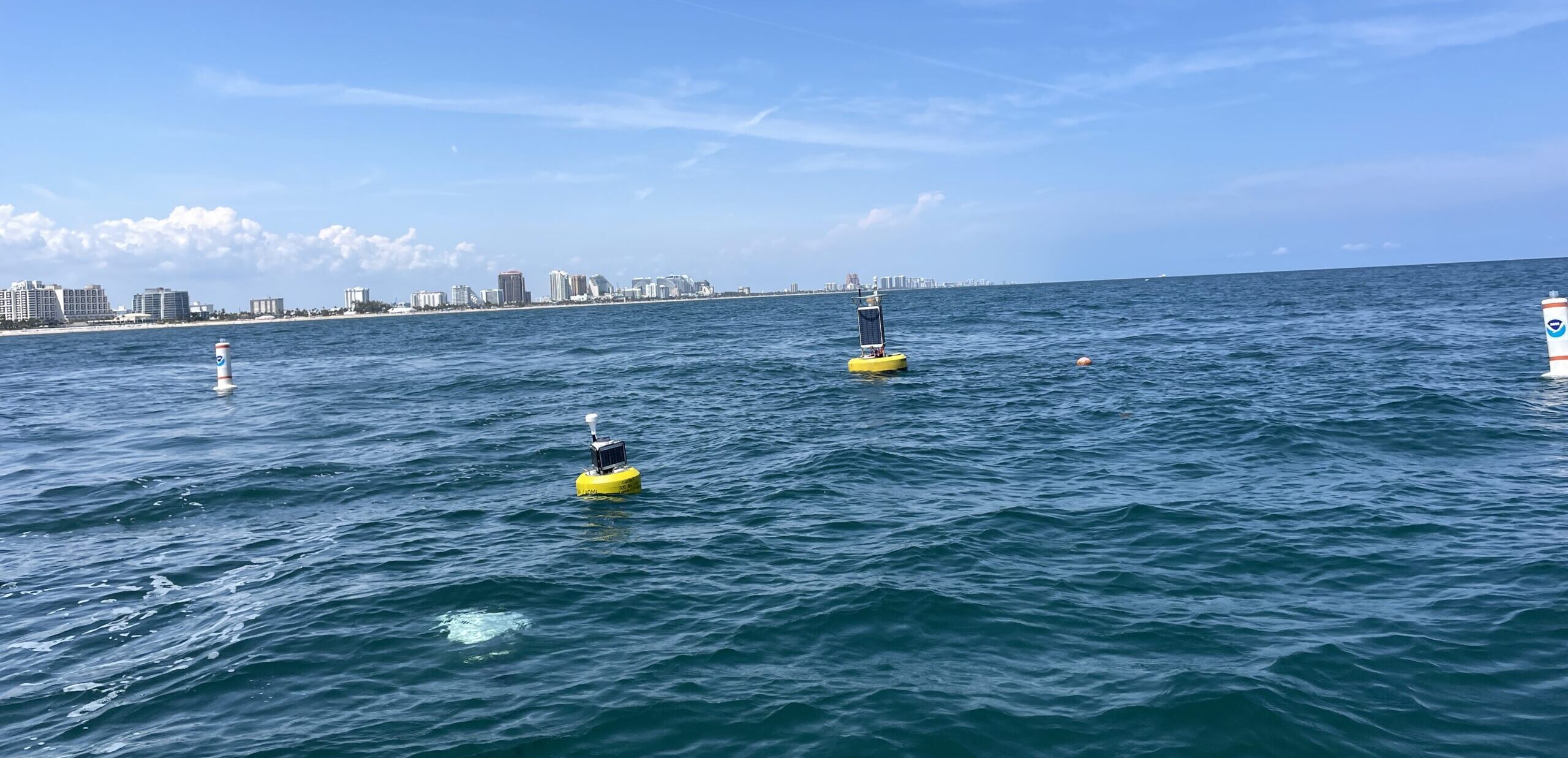
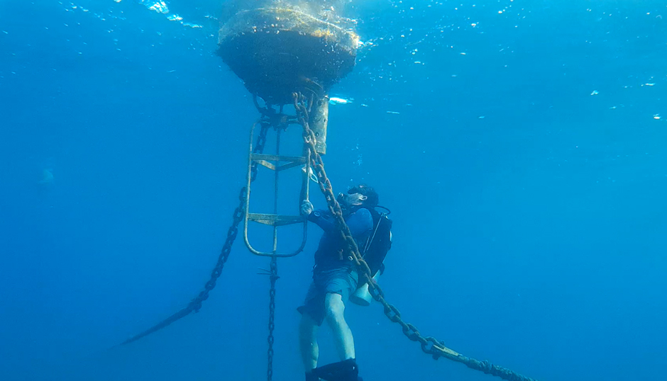
A CB-950 and CB-25 deployed on site at Port Everglades. The sensor buoys are protected by white buoys on the sides to prevent collisions with boats in the area. (Credit: Jhon Mojica / CIMAS-UM)
Sediment Plume Monitoring During Dredging Operations
Due to the size and potential impact of the Port Everglades dredging project, NOAA and the US Army Corps of Engineers have been tasked with monitoring the Port before, during, and after the channel expansion.
Dr. Enrique Montes, Associate Scientist of the University of Miami Cooperative Institute for Marine and Atmospheric Studies (CIMAS) affiliated to NOAA’s Atlantic Oceanographic and Meteorological Laboratory (AOML), oversees real-time monitoring systems collecting water quality conditions off the channel of the Port.
Montes explains, “During dredging operations, sediment plumes should be monitored to mitigate harmful effects on the benthos and minimize possible coral disease outbreaks that have previously been associated with dredging projects like the ones observed in the Florida Keys.”
Near real-time systems can help with measuring turbidity at the top and bottom of the water column, and alert operators and overseers of the project to pause or slow dredging to prevent sediment plumes and minimize impacts.
“The idea is to deploy a whole array of sensor packages on the seafloor and data buoys at the surface that will be collecting data every 15 minutes and transmitting data with near real-time capability so that we can track major changes in turbidity and water quality conditions that may harm the coral reef as a result of sediment plumes coming out of the dredging area,” he continues.
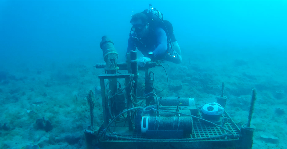
Divers are servicing the bottom package by cleaning the sensors and checking their functionality.
A bottom-deployed sensor array equipped with an Echologger ECT400 altimeter, Aqua TROLL 600 (In Situ), acoustic modem, NexSens data logger, Nortek wave/current meter, an ECO-PAR sensor that measures photosynthetically active radiation–specifically the light levels crucial for photosynthesis, and LISST-ABS acoustic sediment sensor continuously monitor sediment dynamics.
The bottom sensor package is powered using alkaline battery packs that are swapped out when needed. Site visits are conducted on a monthly basis and include sensor cleaning, battery replacement, and any other necessary maintenance or troubleshooting.
The NexSens logger collects and stores data from the sensor package, and then the acoustic modem transfers the data through the water column to a CB-950 data buoy on the surface.
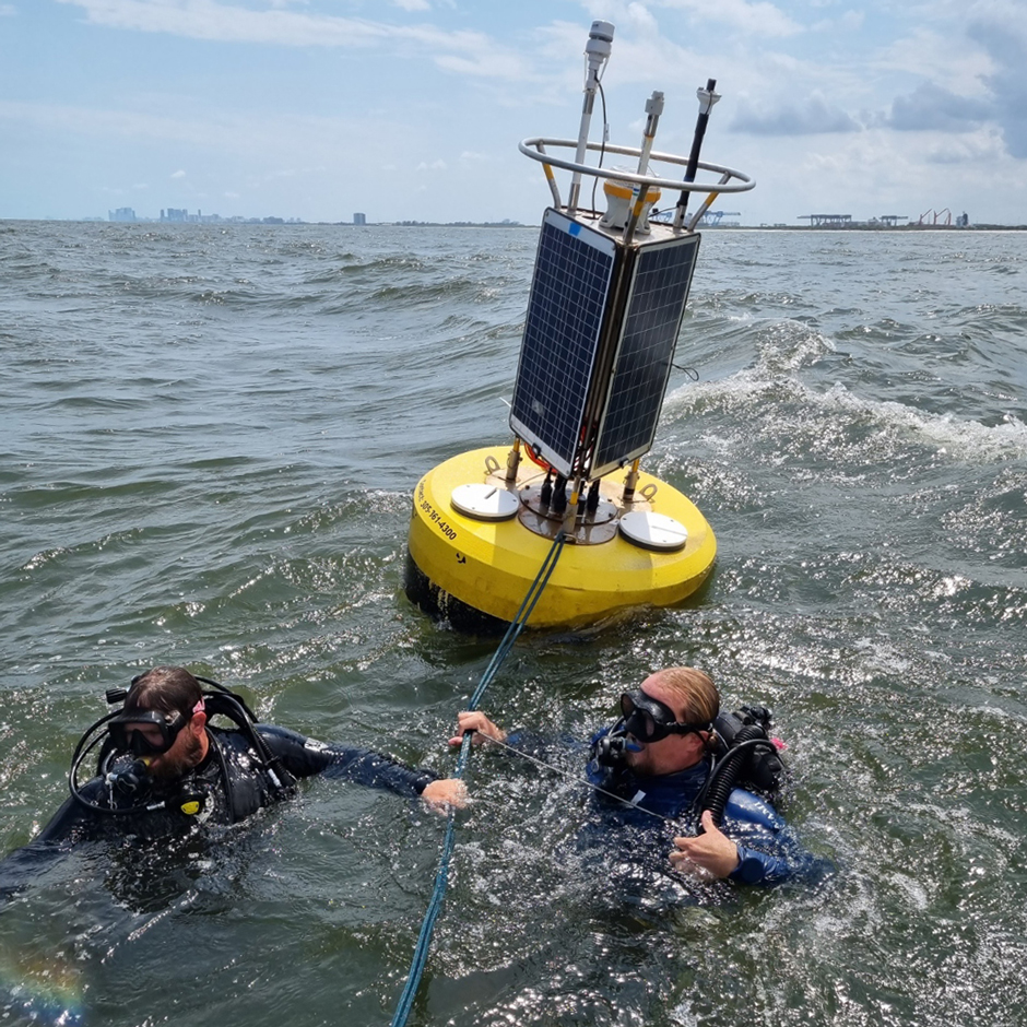
Scuba divers attaching the surface buoy to the bottom anchors using lines and chains. (Credit: Jhon Mojica / CIMAS-UM)
Data is then logged by a NexSens data logger on the surface buoy and then transferred to the cloud, where the data can be viewed via WQData LIVE. In addition to the bottom sensor package’s data, the buoy is equipped with a suite of surface water sensors.
An Airmar multiparameter weather station and LI-COR PAR sensor measure climate conditions. Additionally, smaller Nexsens data buoys (CB-25 and CB-75) equipped with surface and bottom Aqua TROLL 500 sensors attached to the mooring line will be deployed in the area to measure temperature, salinity, chlorophyll-a, and turbidity.
The buoys are all equipped with solar panels, which makes the surface systems more self-sufficient compared to the bottom array and limits the need for intervention.
Currently, only one bottom sensor array and a surface buoy have been deployed to establish a baseline of conditions in Port Everglades and document natural sediment plume formation from climate conditions.
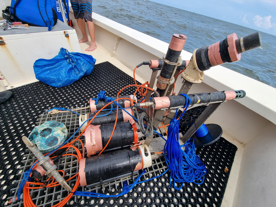
The bottom package is ready to be deployed. The instruments are wrapped in special tape to prevent biofouling accumulation. (Credit: Jhon Mojica / CIMAS-UM)
This early monitoring will help to identify and troubleshoot challenges, aid in collecting baseline data to characterize the natural variability in turbidity conditions, develop algorithms that trigger early-warning alerts transmitted via email and cell phone messaging, and eventually inform management once dredging begins.
Prior to the first dredging operation, three additional bottom sensor packages will be deployed in the Port Everglades, along with 12 smaller NexSens buoys.
While the bottom sensors will remain the same, the smaller surface buoys will include a Nexsens data logger and two Aqua TROLL 500s. One of the Aqua TROLLs will be positioned just below the surface, and the other will be a few feet above the seafloor.
Divers servicing the surface buoy by cleaning the sensors to eliminate biofouling accumulation. (Credit: Jhon Mojica / CIMAS-UM)
Minimizing Ecological Impacts Inside and Outside of Port Everglades
Corals and other benthic species are critical components of marine ecosystems, serving as habitat and food sources for other species, including humans. These organisms will be the most impacted by the project as the sediment they live on is removed.
“This is going to be a massive project that will entail transplanting big corals from one location to another, assessing and characterizing benthic habitats—there are certain areas of conch aggregation reproduction that may be affected by these activities, and we’re in the process of figuring out how to monitor turbidity conditions in these aggregation sites” states Montes.
Early research and monitoring will help inform translocation efforts and protect these key species during dredging operations. Paired with continuous sediment plume monitoring of the project, Montes is hopeful that the project can be completed with minimum impacts on marine life.
He explains, “The data that we’re collecting is going to be really important to help us to at least mitigate, to some extent, the level of damage that is going to be caused by dredging in this area.”
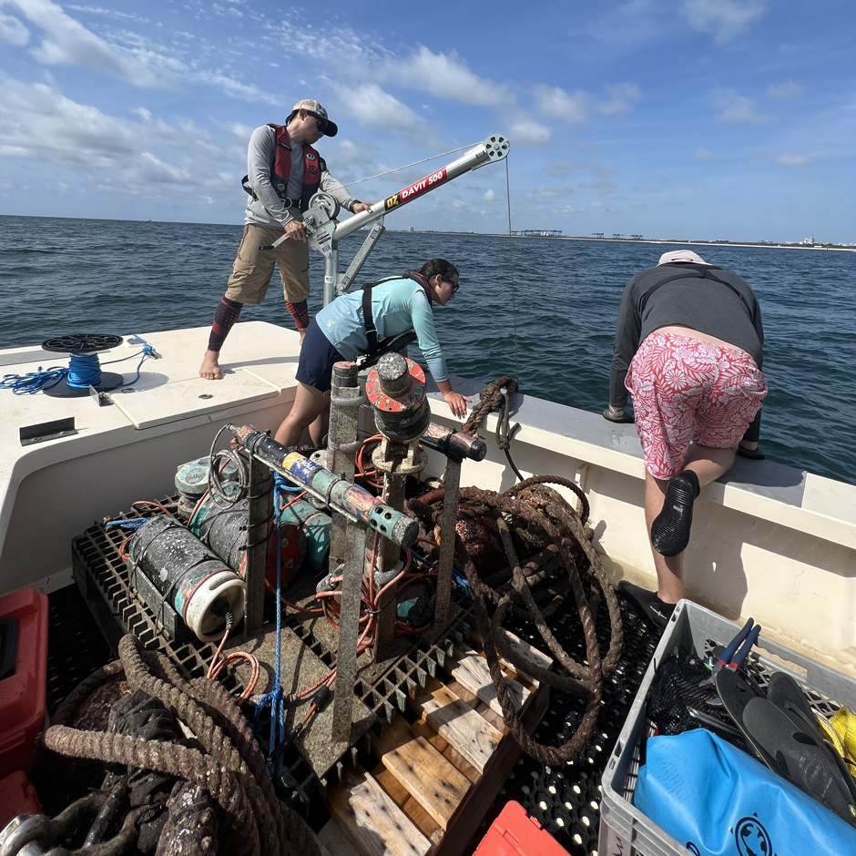
The bottom package being recovered for a full service (cleaning and communication checks) using a davit. (Credit: Jhon Mojica / CIMAS-UM)


0 comments