Researchers Map Earth’s Mantle Underneath Juan De Fuca Plate

For years, scientists have surmised the roles that the Juan de Fuca plate plays in causing earthquakes in the Pacific Northwest. But thanks to a recently completed long-term study, they may have fewer guesses on its dynamics.
A large team of scientists has just wrapped up an effort to map the plate in what was part of the Cascadia Initiative, a large-scale seismic experiment taking place along the United States’ western seaboard. Five members of the team zeroed in on the plate to describe how its movement is connected to the flow of the Earth’s mantle underground.
The aim is to understand forces that generate large earthquakes all over the world, in addition to those that occur in the region. By understanding large-scale tectonic processes, scientists believe they can link them all the way down to smaller scales and, eventually, to specific earthquakes in the Pacific Northwest.
The work relied on a large network of seismometers that has been deployed around the Juan de Fuca plate over the past four years.
“The experiment was unprecedented in that there were 70 seismometers deployed at a time, sitting there for 10 months, which is much bigger than any other ocean-bottom experiment ever done before,” said Robert Martin-Short, a University of California, Berkeley, graduate student and first author of a paper detailing the effort, in a statement. “We’ve learned a lot from the deployment of these new instruments, and now have a giant array that we know works well on the seafloor and which we can move somewhere else in the future for a similar experiment.”
Though it was technically challenging to mount the seismometers to the seafloor, researchers say the offshore environment they were working in is a simpler place to study tectonic plates because the plates are thinner and more uniform there. This allows them to “see through” them to get a better sense of what’s occurring below.

An ocean bottom seismometer being retrieved after spending 10 months on the floor of the Pacific Ocean to map the mantle 100 miles underneath the Juan de Fuca plate. (Credit: University of California, Berkeley)
Deploying the seismometers required 24 two-week ocean voyages to place and retrieve them. This helped the researchers while also giving students opportunities to participate in field-based research. These came from schools including UC Berkeley, Columbia University, University of Oregon, University of Washington and Imperial College in the United Kingdom.
Most of the seismometers have been pulled and their data are providing scientists with some takeaways on the Juan de Fuca plate’s role in earthquakes.
For example, researchers have found that the flow of the Earth’s mantle beneath the Juan de Fuca ridge, which is located about 300 miles offshore of Seattle, is flowing perpendicularly to the ridge. That is something that has long been predicted to exist, but never confirmed. Scientists believe it flows that way because the plate is dragging the underlying mantle eastward with it.
In addition, researchers also found that part of the Juan de Fuca plate, called the Gorda plate, is not coupled to the Earth’s mantle. This means the mantle beneath it can move independently. Instead of being linked to the Juan de Fuca plate, it appears that the Gorda plate is aligned with the Pacific plate.
“The Juan de Fuca plate is clearly influencing the flow of the mantle beneath it, but the Gorda plate is apparently too small to affect the underlying mantle,” said Richard Allen, chair of the Earth and Planetary Science department at UC Berkeley and the study’s senior author, in the release.
But the biggest surprise to Allen so far is that the movement of a small piece of the mantle beneath the Juan de Fuca plate appears different from that of the rest of the plate, which is resulting in the subduction zone being segmented. That sort of segmentation is seen in Pacific Northwest megaquakes that produce magnitude 9 or greater events.
Results of the study detailing what researchers have found so far are detailed in the journal Nature Geoscience. More findings are expected as they continue to sift through the data.
The Cascadia Initiative is led by the University of Oregon and funded by the National Science Foundation through monies it received through the 2009 American Recovery and Reinvestment Act.

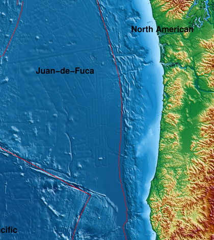
The red line outlines the Juan de Fuca plate that is moving eastward, shoved under the continental North American plate and generating megathrust earthquakes. (Credit: University of California, Berkeley)


0 comments