
Current Monitoring after the Francis Scott Key Bridge Collapse
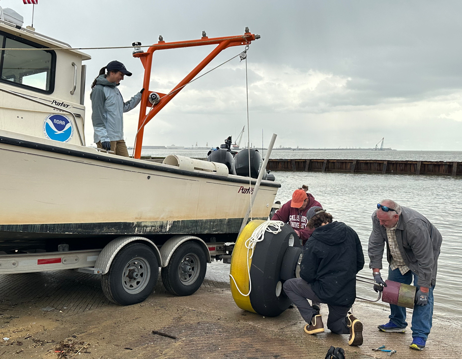
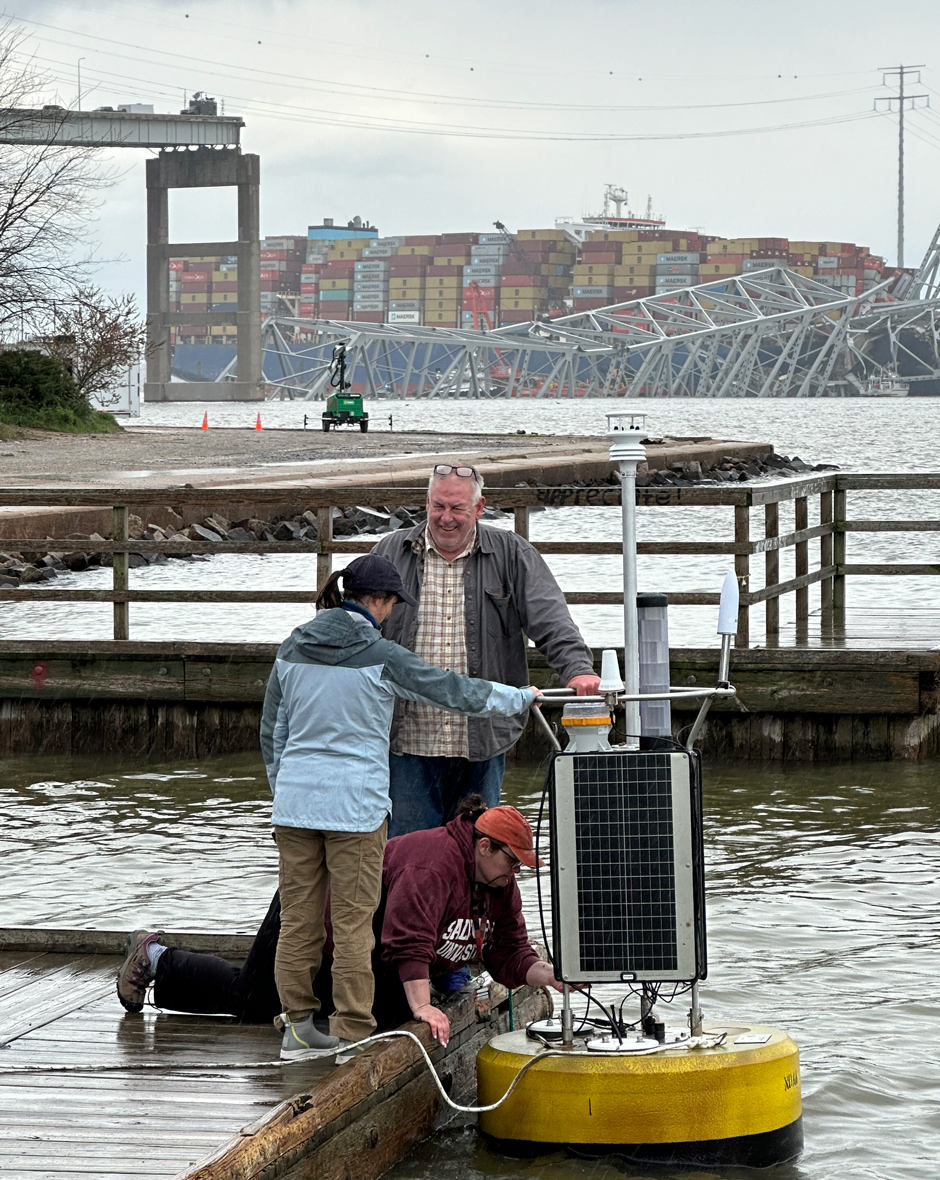 Field crews prepare NOAA’s CURBY for temporary deployment near the collapsed Francis Scott Key Bridge on April 4, 2024. Pictured clockwise from top: Eddie Roggenstein, Shaena Rausch, and Katie Kirk. (Credit: NOAA CO-OPS)
On March 26th, according to The Baltimore Sun, a 984-foot, 112,000-ton Dali lost propulsion and collided with a support column of the Francis Scott Key Bridge, collapsing the structure. Soon after the event, search and rescue, salvage crews, and other emergency responders were mobilized after the collision.
As salvage efforts progressed in early April, NOAA’s Center for Operational Oceanographic Products and Services (CO-OPS) responded to a request for real-time tidal currents data and deployed a current monitoring buoy—CURBY (Currents Real-time BuoY)—into the Patapsco River north of the Francis Scott Key Bridge.
Monitoring Currents with Buoys
Designed and field tested in 2018, the CURBY is a compact, easily deployable surface buoy created by NOAA to support operational decision-making and planning for scientific coastal research and disaster response.
NOAA’s CURBY measures a variety of oceanographic and meteorological parameters, including wind speed and direction, current speeds and direction, relative humidity, barometric pressure, and air and water temperature. For the Key Bridge response, wind and current speeds and directions were particularly vital for federal, state, and local efforts to restore marine navigation in the Patapsco River.
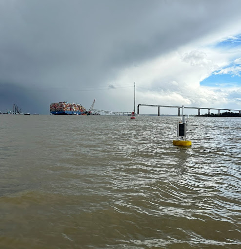
NOAA’s current monitoring buoy, CURBY, deployed near the Francis Scott Key Bridge collapse. (Credit: NOAA CO-OPS)
Robert Heitsenrether and Lorraine Heilman, of CO-OPS’s Engineering Division, were part of the team that designed, constructed, and tested the CURBY buoy.
Heitsenrether explains, “Tidal current surveys conducted by NOAA’s National Current Observation Program, required improved observations of near surface currents and a new surface buoy was the ideal design.”
CURBY’s first use dates back to 2019, when CO-OPS deployed the nascent system into the Delaware Bay and River in support of NOAA’s tidal current survey led by Oceanographer Katie Kirk.
The first CURBY system consisted of a single CB-950 equipped with an Airmar WX200, Nortek Acoustic Doppler Current Profiler (ADCP), Hach\Hydromet Sutron data logger, and satellite transmitter. More recent renditions of the CURBY now feature a Gill GMX560 in place of the Airmar, and an In-Situ Aquatroll 200 sensor to measure water conductivity and temperature.
Building on the success of the original CURBY, two additional systems were developed in 2021 to support disaster response in the Gulf of Mexico region. After this project, two more CURBY systems were developed for use in NOAA’s 2022-2023 Columbia River tidal currents surveys.
Over the same time period, the original CURBY buoy was re-deployed off the coast of Savannah, GA, in order to support NOAA’s Savannah River tidal currents survey. Data collected by NOAA’s tidal current surveys are used to update the Nation’s tidal current predictions in a given region.
“[The Columbia River], in particular, is a sandy bottom river with sand waves that reach 10 to 15 feet in height and regularly sweep through the river’s bottom. Many of our typical current sensor deployment setups that we would otherwise use. For example, bottom mount sensors were not appropriate for our Columbia River currents survey,” elaborates Heilman.
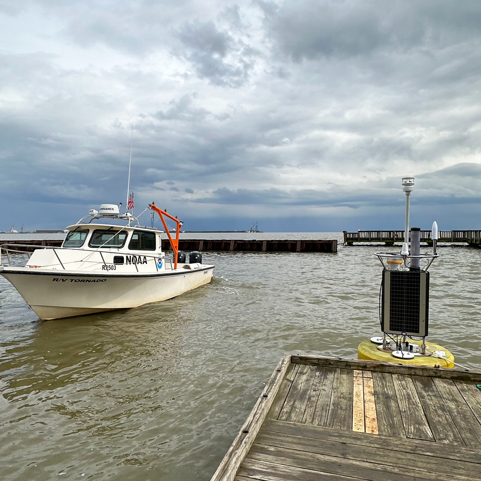
The CURBY real-time buoy is easily deployed from small vessels like NOAA’s R/V Tornado, pictured here on the left. (Credit: NOAA CO-OPS)
“Having the CURBY, a versatile instrument that I could put anywhere in the river where we needed a measurement, really helped ensure that our currents survey was a success. In total, we were able to deploy, retrieve, and re-deploy two CURBYs a total of six times in the river. Those were six locations that, without the CURBY, we would not have been able to get any measurements,” continues Heilman.
Monitoring After the Francis Scott Key Bridge Collapse
When the Francis Scott Key Bridge collapsed on March 26th, the US Coast Guard and NOAA’s Office of Response and Restoration called upon CO-OPS to establish real-time currents and meteorological (e.g., wind, humidity, etc.) observations in the Patapsco River to support multiple recovery and salvage efforts. According to the CO-OPS team working on the deployment, the CURBY buoy was the ideal solution to deliver quick, accurate results.
With an already assembled CURBY system positioned at the CO-OPS Chesapeake, VA field office, NOAA was able to quickly prepare the instrument for deployment and get it deployed in Baltimore only days later.
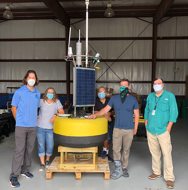
CURBY with NOAA CO-OPS staff members Robert Heitsenrether, Grace Gray, Warren Krug, Winston Hensley, and the Office of Response and Restoration’s Charlie Henry. (Credit: NOAA)
The current and meteorological data gathered by the system in part to support, dive and salvage operations, and also to provide navigational support. Already having a designed and tested system to deploy was one of the main reasons CO-OPS was contacted for the project as it allowed for quick deployment.
Because the CURBY needed to be in the water within a matter of days, the CO-OPS team had to expedite a lot of the paperwork and setup, which they could usually spend weeks to months preparing. Permits and environmental compliance documents all had to be completed and approved before the system was deployed.
Deploying the buoy near Baltimore at such short-notice raised a number of logistical issues. Although compact, the CURBY is generally deployed from a vessel with lifting capability. In Baltimore, the team had limited lifting capability to offload, assemble, and prepare the buoy for deployment—making this deployment slightly more challenging than usual.
An unfamiliar launch site, boat ramp, and inclement weather conditions also presented a challenge during the buoy’s deployment. Ultimately, the deployment was a success, and the CURBY was moored in its current position by NOAA’s 25-foot vessel R/V Tornado.
Before the buoy was deployed, there was a great deal of discussion surrounding its ultimate location. This detail can impact how the instrumentation is programmed and the naming of the system in NOAA’s database. The goal of this project was to provide real-time data to the public and recovery partners as soon as possible following the buoy’s deployment.
The CURBY buoy is assembled on-site by a small team of NOAA engineers and oceanographers. (Credit: NOAA CO-OPS)
Kirk explains, “The buoy changing locations could potentially affect how the current meter was configured, and it could affect the mooring length depending on the total water depth.”
Heilman adds, “In order to actually ensure functional real time data, we were changing a lot parameters on the fly as the buoy was being installed. Those of us back on land also played our part in making sure the buoy was operational, and specifically making sure there was real-time data coming through.”
Conclusion
While long-term datasets can inform and shape our current understanding of waterways, real-time monitoring can provide data critical for more short-term emergency applications. NOAA’s CURBY buoy will remain deployed at the Francis Scott Key Bridge site while cleanup and recovery continue.
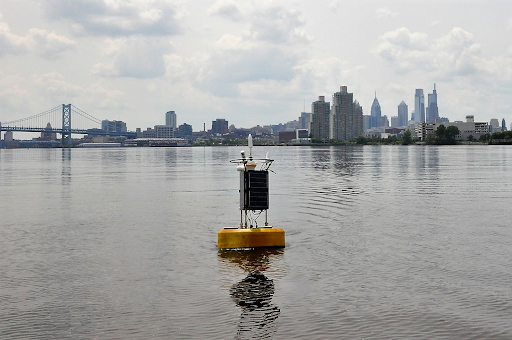
The first operational deployment of the CURBY occurred in the Delaware Bay and River. (Credit: Katie Kirk / NOAA CO-OPS)


0 comments