Filled to the brim

Scientists researching North Dakota’s Devils Lake often focus more on water quantity than quality, and for good reason. They have too much.
Since 1993, the lake has risen 30 feet. Its volume has swelled by seven times and its surface expanded by 260 square miles, submerging homes, farms, and businesses.
 “You have to look at Devils Lake to see how dramatic the flooding is,” says Xiaodong Zhang, associate professor of earth systems science and policy at the University of North Dakota. “There are streets signs that are barely above the water. Some roads go to into the water and just disappear.”
The flooding has led to extensive research asking why there is suddenly so much water and how much more they can expect (an exceptionally strong recent flood cycle is mostly to blame). State, federal and local officials who have grappled with the extra water for decades are expanding controversial man-made outlets that pump Devils Lake water to the neighboring watershed. Such decisions hinge on critical issues of water quantity, but when moving water from one watershed to another, water quality is just as important.
“The more we looked at it, a deeper issue is that many people don’t know the water quality,” Zhang says. “There’s no such continuous monitoring of the quality of the water even though we all know the level of the lake. That’s released every day.”
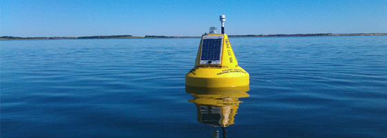
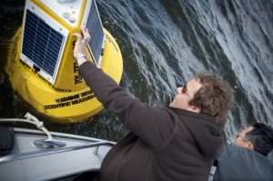
To address that lack of water quality monitoring, Zhang launched a NASA-funded buoy in the fall of 2011 equipped with a meteorological station and sensors that continuously measure several water quality parameters. Before Zhang pulled the buoy out of the lake for the winter, it floated in the eastern-most section of the lake, once a separate body of water called Stump Lake. Water began spilling into Stump Lake in 1999, and by 2007 it had risen 31 feet and the two lakes had merged into one.
The buoy’s sensors measure temperature, turbidity, dissolved oxygen, chlorophyll, and salinity. Salinity is particularly important in Devils Lake, which has no natural outlet. As long as the lake level stays below 1,458 feet above sea level, the lake’s only natural water loss is through evaporation. Evaporation leaves behind dissolved solids like undesirable sulfates and makes the water ten times saltier than a normal lake.
The result? “Nobody wants this water,” Zhang says.
Which is a problem, because they’re going to get it anyway. In an effort to slow the rising water, the North Dakota State Water Commission in 2006 switched on pumps at a man-made outlet that originally moved water out the lake’s west end and into the Sheyenne River at 100 cubic feet per second. The commission later increased the capacity of the west end outlet and began construction on an even bigger outlet on the lake’s east end. A third outlet is under development, this one a gravity-operated system that will move between 20 and 600 cubic feet per second, depending on how high the lake rises.
 The outlets have been controversial with downstream communities and governments because the connections form an unnatural link between the Devils Lake basin and the Sheyenne River, which flows into the Red River and Lake Winnipeg in Canada. Outlet opponents are concerned that Devils Lake water will taint their rivers with sulfates, new fish pathogens, and invasive species. The outlets will operate under U.S. Environmental Protection Agency standards that limit the amount of sulfates allowed in the Sheyenne. An assessment by the International Joint Commission, a bi-national group that advises the U.S. and Canadian governments on issues related to waters that straddle the border, determined that the risk of the outlets introducing new fish pathogens is low.
Opponents also worry about the effect of additional water flowing from Devils Lake into their already flood-prone rivers. Major floods struck the Sheyenne River in 2009 and the Red River in 2009 and 2011. The State Water Commission says that the flow from the outlets will be cut back if there is a chance of contributing to downstream floods, but without controlled water diversions from the rising lake, the effects on Sheyenne River flooding could be even worse.
That’s because if Devils Lake rises another five feet from its current level and surpasses 1,458 feet above sea level, it will eventually spill over into a ravine that forms a natural channel between the former Stump Lake and the Sheyenne River. If that happens, scientists estimate that it would likely be just the third time in 4,000 years that the two basins were joined by water flowing through the ravine. According to the U.S. Army Corps of Engineers, a spillover could escalate into a torrent of water flowing at at least 12,000 cubic feet per second for 19 days, causing catastrophic flooding along the Sheyenne. The State Water Commission is in the process of building a dam-like control structure in the ravine to manage the flow in the case of a spillover.
To make matters even worse, Stump Lake’s water has the highest sulfate concentration in Devils Lake, so a spillover will send the lake’s lowest-quality water into the Sheyenne. Despite this, sulfate monitoring has been limited to spot sampling, Zhang says. That’s one reason he chose to put the buoy in Stump Lake. Though the buoy doesn’t measure sulfates, its continuous salinity measurements can give a good indication of sulfate concentrations, he says.
According to the USGS, there’s a 10 percent chance the lake could rise high enough to spill in the next 20 years. In the meantime, Zhang stresses that the buoy will serve a greater purpose than acting as a sentinel for sulfate levels when it goes back in the water this spring. The measurements will give researchers and managers new tools to understand what drives water quality in the lake as well as what drives water quantity. With this data, they’ll be able to model how the lake’s salinity, dissolved oxygen, and algae production respond to environmental changes in rain, snow cover, or temperature.
“If you just pick salinity out, it really takes the whole thing out of context,” he says. “We want to elevate our overall understanding of the lake.”


0 comments