
From Pans to Buoys: Advancing Reservoir Evaporation Rate Monitoring in Texas
In warmer climates like Texas, high reservoir evaporation rates can lead to declines in water level and water availability during droughts, making monitoring essential in order to ensure water security during times of scarcity.
According to the Texas Water Development Board (TWDB), evaporation rates in Texas were previously based on data collected from a sparse network of Class A evaporation stations, dating back to the 1960s. These pans were stationed near reservoirs and still remain a widely accepted standardized approach to measuring evaporation rates on land.
Monthly pan-to-lake coefficients were developed in the 1980s to connect the data collected from the pans to known lake conditions, extrapolating evaporation rates of the lakes using the pan data.
“We were acutely aware of the uncertainties associated with reservoir evaporation rates based on Class A pan evaporation data. We were also aware of advances being made by the U.S. Bureau of Reclamation and the Desert Research Institute in observing open water evaporation, and that accurate estimation of reservoir evaporation requires that measurements be taken on the lake,” states Dr. Nelun Fernando, Manager of the TWDB’s Water Availability Program.
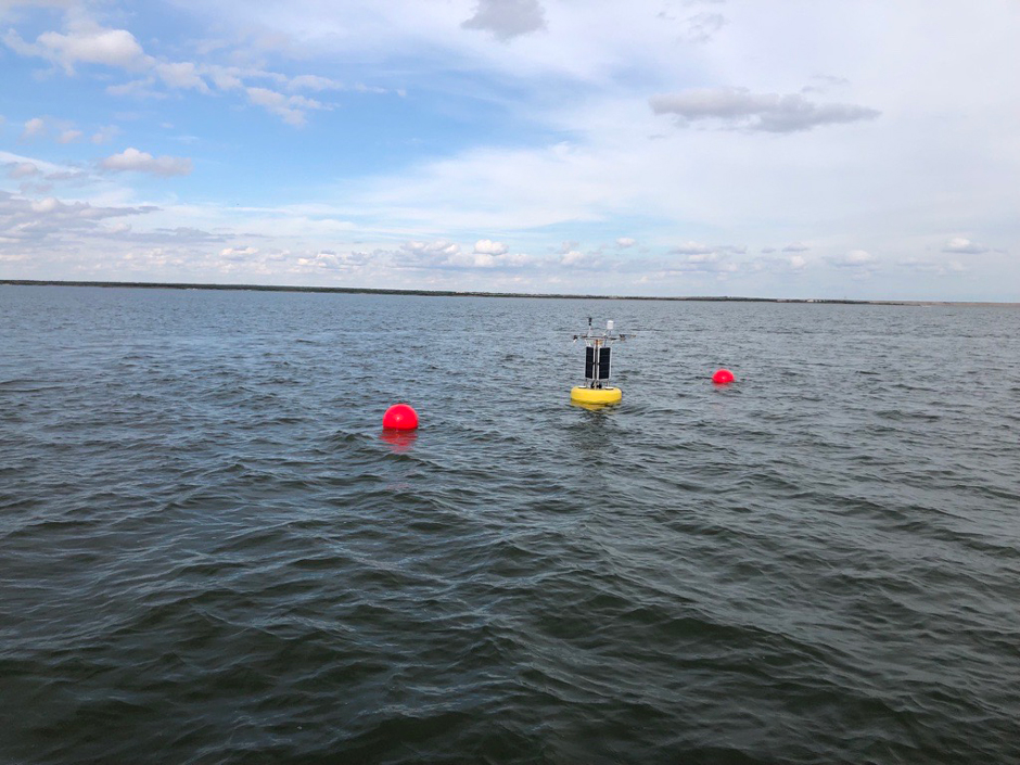
Buoy on Choke Canyon Reservoir. (Credit: A. Burke, TWDB)
Monitoring Reservoir Evaporation Rates
Andy Weinberg, Team Lead for the Recorder Well Program in the Groundwater Monitoring Department at the TWDB, collaborated with the TWDB’s Water Availability Department to establish an experimental floating eddy covariance station in 2018.
The experimental platform measures the exchange of gases in a closed system and can help the TWDB better understand how climate conditions influence lake resources.
Building on the experience gained through the trial, Weinberg and Dr. Fernando jointly developed the scope of work for the grant application to the U.S. Bureau of Reclamation’s WaterSMART Drought Resiliency fund, which was used to purchase the equipment needed to develop the evaporation rate monitoring network across four major water supply reservoirs.
“The project’s goals are to strengthen reservoir evaporation monitoring in Texas and build correlations between the last 60-plus years of monitoring based on Class A evaporation pan stations and a 21st century program that takes advantage of new technologies,” explains Dr. Fernando.
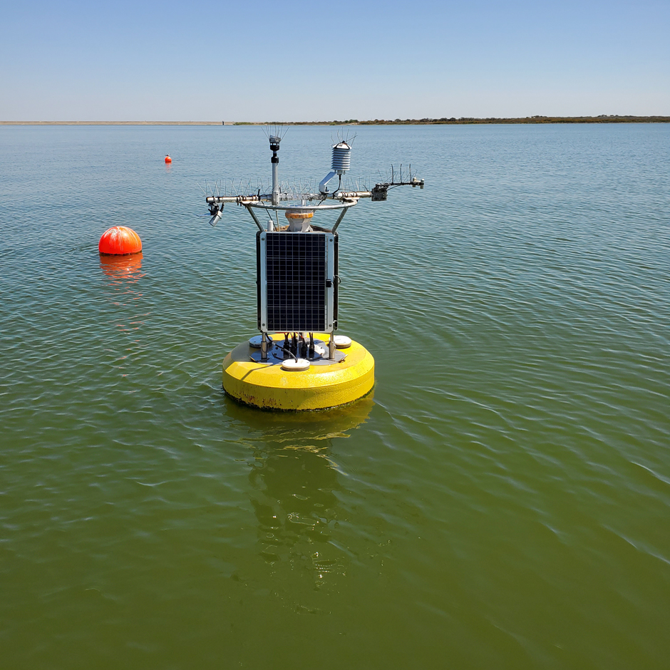
Four total NexSens CB-650 buoys were deployed across Lake Buchanan, Choke Canyon Reservoir, Lake Meredith, and Red Bluff Reservoir. Each system was equipped with meteorological and water temperature sensors, which continuously collect the data needed to estimate reservoir evaporation.
The buoy stations report meteorological and water temperature data at 5-minute intervals, synching with the TexMesonet network’s data reporting frequency.
In addition to the buoys, the program also pulls data from the Collison Floating Evaporation Pan system on Twin Buttes Reservoir, which collects meteorological data and measures evaporative water loss in a pan deployed in the reservoir.
While there is evidence that shore-based meteorological measurements can be used to replicate pan readings (Harwell, 2012), correlating these shore-based measurements with actual lake evaporation remains a challenge.
Dr. Fernando elaborates, “Differences in micro-meteorological conditions between the lake and shore sites and the complex energy storage and release dynamics in large reservoirs suggest that accurate estimation of reservoir evaporation requires measurements taken on the lake.”
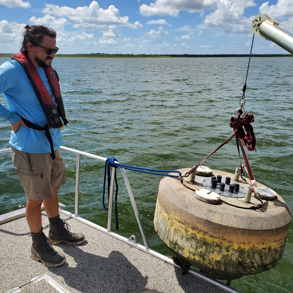
Maintenance of buoy on Choke Canyon Reservoir. (Credit: A. Burke, TWDB)
Using Evaporation Data
The TWDB is the state agency charged with ensuring a secure water future for Texas. It is responsible for collecting, compiling, and disseminating data to monitor, quantify, and simulate surface water and groundwater conditions; assisting with regional water supply and flood planning; and managing cost-effective financial programs for constructing water supply, wastewater treatment, flood control, and agricultural water conservation projects.
The TWDB’s Water Availability Department is responsible for interpreting and sharing the data collected at Class A evaporation pans located within Texas and neighboring states. The data collected by the pans are used as input to the water availability models for Texas that are used to determine water permitting and long-range water planning.
Additionally, the data collected from the buoy stations are being used to calibrate and validate a new modeled, reservoir-specific evaporation data set for Texas (Zhao et al., 2024) and to update the legacy pan-to-lake coefficients for reservoirs that have both a pan station and a buoy.
Notable findings from the buoy stations include observations of sub-daily spikes in evaporation that coincide with wind gusts on the lake, something not captured by the modeled data. Additionally, wind speeds and dewpoint temperatures measured by the buoys differ from the land-based pans.
“While this is not surprising, it reinforces the need to collect measurements over water because the land-based data may not accurately represent conditions over water,” states Dr. Fernando.
Though the buoys come with additional maintenance needs—compared to the floating eddy covariance station—the data collected on the lake is critical to calibrating the evaporation rate models currently used for reservoir operations.
Dr. Fernando adds, “Furthermore, the water column profile temperature data and solar radiation data collected at the buoys are invaluable for estimating the energy budget for reservoirs which is […] used to validate modeled reservoir evaporation rates and to close the energy budget for eddy covariance measurements.”
Buoy on Choke Canyon Reservoir. (Credit: A. Burke, TWDB)
Conclusion
Ultimately, the buoys have helped further refine evaporation rate research in Texas. This data will go on to help develop solutions and “crack the puzzle” on how much water is lost through evaporation in water supply reservoirs, according to Dr. Fernando.
She continues, “The knowledge gained from the datasets we collect are used operationally for water management decisions, and it is rewarding to know that the enhancements we have implemented to improve the accuracy of reservoir evaporation data will directly contribute to improving assessments of current and future surface water availability in the state.”
References
Harwell, G.R., 2012, Estimation of evaporation from open water—A review of selected studies, summary of U.S. Army Corps of Engineers data collection and methods, and evaluation of two methods for estimation of evaporation from five reservoirs in Texas: U.S. Geological Survey Scientific Investigations Report 2012–5202, 96 p.
Zhao, B., Huntington, J., Pearson, C., Zhao, G., Ott, T., Zhu, J., Weinberg, A., Holman, K. D., Zhang, S., Anderson, R., Strickler, M., Cotter, J., Fernando, N., Nowak, K., & Gao, H. (2024). Developing a General Daily Lake Evaporation Model and Demonstrating Its Application in the State of Texas. Water Resources Research, 60(3), e2023WR036181. https://doi.org/10.1029/2023WR036181


0 comments