
High Definition Stream Surveys: Informed Management in Local Waterways
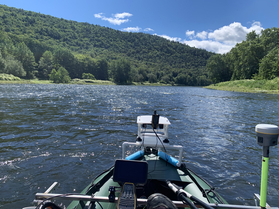 High Definition Stream Survey motor boat in action on the Upper Delaware River in Pennsylvania. (Brett Connell / Trutta)
When it comes to environmental monitoring, new stream survey methodologies have revealed a great deal about water quality and streambed conditions over time. Such information can be particularly important in leading restoration initiatives and prioritizing management decisions.
Historically, stream surveys have been conducted at a single point along the stream, with data then extrapolated for miles up and downstream. However, Brett Connell, Hydrologist and Director of Sales at Trutta Environmental Solutions, started developing a more intensive stream survey format in his master’s program in 2010 at the University of Tennessee.
Having grown up fishing in Lake Erie and the Maumee River, Connell chose to pursue a career initially in fisheries biology because he loved being outdoors and working in the landscape he was studying.
“I remember sitting in a stream during my first internship with the Ohio EPA and said, ‘So this could be my office?’ And I was like, ‘This is awesome!”

Trutta employee waiting for power generation at Harris dam on the Tallapoosa River, AL. (Brett Connell / Trutta)
High Definition Stream Surveys
While Connell began developing this new way to collect stream data in college, Trutta’s R&D team has spent years transforming it into the High Definition Stream Survey (HDSS) method—an approach to rapidly gather continuous, meter-resolution GIS data in a single pass for a broad range of stream corridor metrics.
By integrating GPS, video, depth, side scan sonar, and water quality sensors, water resource managers now have a continuous baseline condition inventory that reaches as far upstream and downstream from a project as needed. With each second of the video linked to a specific GPS point, data viewers are now able to identify, select, and prioritize areas of the river for multiple different water resource issues.
The results can be used to determine the most economical location and methods for mitigation, monitor restoration results, determine the extent and distribution of instream habitat, define the geomorphic condition for the stream, identify infrastructure impacts, and provide a powerful “virtual tour” experience.

Example of the High Definition Stream Survey Streamview deliverable. (Jim Parham / Trutta)
Use of High Definition Stream Surveys in the Field
Connell manages all of the field projects for Trutta, and as the popularity of HDSS grows, so do the opportunities. One example of this success is an Abandoned Mine Land (AML) project in Hurricane Creek, Alabama, which helped identify impaired water quality conditions, current threats to the aquatic system, and specific areas for restoration.
Over 23 days, 250 continuous miles of Hurricane Creek and its tributaries were surveyed by employees of Trutta Environmental Solutions. Out of the 250 miles, 27 miles were done by kayak and the remaining 223 were by backpack.
While conducting the HDSS, Connell reported finding damage caused by stormwater issues, infrastructure issues, sedimentation from silviculture practices, trash, livestock impacts, perched culverts, and other hazards that were impacting the environment.
“We saw all sorts of issues. So, while we were there documenting the Abandoned Mine Land impacts, we saw many other types of impacts in different areas of the watershed,” states Connell.

Jim Parham operating the High Definition Stream Survey backpack on the North Fork Wailua River on Kauai. (Brett Connell / Trutta)Jim Parham operating the High Definition Stream Survey backpack on the North Fork Wailua River on Kauai. (Brett Connell / Trutta)
The stream surveys also revealed how the abandoned mine lands impacted the waterway, with certain areas of the creek having pH levels ranging between 3.2 and 4.0—which is considered highly acidic water.
“When we go out there, we document everything—that’s the beauty of it. We’re not only gathering information for stormwater or only gathering information for the Bank Erosion Hazard Index, we really broaden how much data and how many purposes that data can have for water resources,” states Connell.
The data collected can help inform resource managers on how best to target restoration initiatives to meet the needs of the system and the species that reside there. The survey also provides a substantial foundation for conditions before restoration, allowing managers to see how restoration has improved conditions years down the line.
“There’s a lot of restoration being done, but there’s not a lot of funding for monitoring. High Definition Stream Surveys serve as a perfect way to show how much impact you’re actually having and where—and so it prioritizes which types of methods are done and where so that you can spend the least amount of money and get the biggest bang for your buck,” explains Connell.

(Credit: Brett Connell / Trutta)
Conclusion
Based on the success of previous projects, HDSS has the potential to shape restoration practices and protect natural resources. An upcoming project on the Wekiva River in Florida is a good example of how these stream surveys can reveal more about a system.
The project’s goal is to collect data on submerged aquatic vegetation, specifically conditions that allow eelgrass to flourish. Eelgrass is important to many native Florida species, but it’s been disappearing in many of the state’s waterways.
“Because there’s threatened and endangered species throughout this watershed that—depending on the depth of the water, the velocity of the water, the type of substrate, the type of habitat type—they’ll be able to use our data to show where the most optimal habitat for these threatened and endangered species is. Or where’s the most degraded habitat that needs to be improved for these species.”
Connell believes that HDSS can be applied anywhere and have meaningful impacts. Ultimately, it’s about collecting meaningful data in a cost-effective way that allows managers to make informed decisions about natural resource conservation and restoration.
He explains, “In order to make informed management decisions, you need to know what all is going on where. And there’s a lot of decisions made on our natural resources with what I believe are incomplete data sets. HDSS provides the most comprehensive, continuous, and valuable data set available.”

Close up of the High Definition Stream Survey backpack. (Nate Royce / Trutta)


0 comments