Icelandic Glaciers: Western Kentucky University Scientists Sample In The Ice

There are lots of glaciers out there that contribute to sea level rise, but those are surprisingly less dynamic than many in Iceland. There is also a sizeable information gap on Icelandic glaciers, as they are much less studied than their more famous melting counterparts.
An investigation led by scientists at Western Kentucky University is trying to change that. The exploratory study is sampling 12 glaciers throughout the country every few months to try and get a handle on the changes that the sheets experience throughout the year. It involves students from the university, the Iceland Meteorological Office and other researchers from the University of Akureyri.
Work there has only just begun, with researchers hoping to return later this year to gather more data.
“We have 12 glaciers and 25 different sites that we’re sampling over a year,” said Jason Polk, associate professor of geoscience at Western Kentucky University. “We want to see how things change from the summer melt to the peak of winter.”
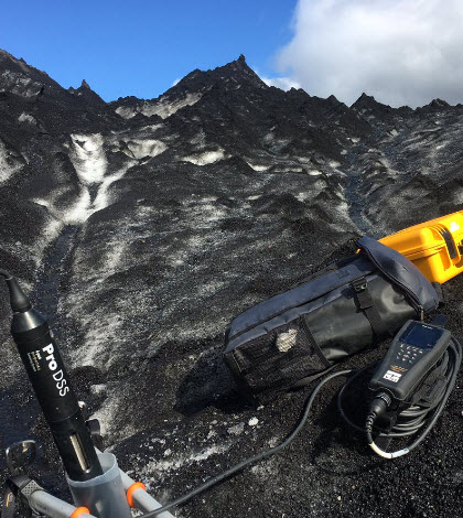
To gauge the water situation in the field, he and others are measuring temperature, pH, conductivity, dissolved oxygen, total dissolved solids, turbidity and nitrates with a YSI ProDSS optical handheld. The variety of data they’re gathering will help to clue them in to where the water is coming from.
“When you’re out in the field, the challenge is to get equipment for study that will stay together,” said Polk of the ProDSS. “But the calibrations have held wonderfully and we’ve gotten some great data.”

Svinafellsjokull glacier in Iceland. (Credit: Flickr User _davidphan via Creative Commons 2.0)
In addition to those direct measurements, researchers are collecting discrete water samples for analysis back in the lab. Things of interest there include radiocarbon and tritium within, which are used to figure out how old the water is.
“A lot are young — less than 1,000 years old. Not a lot has been done to measure the dynamics of the substrate meltwater,” said Polk. “We’re also doing a texture analysis, trying to characterize the chemical and physical parts of samples.”
Polk says he and others are also capturing meltwater samples at the glacial surface and then downstream where they feed the ocean. The idea there is to see how conditions can change over distance.
The Meteorological Office, which is chipping in some of its monitoring data, is interested in learning more about flooding that sometimes occurs near the glaciers. This can take place due to glacial lakes that burst through the ice and submerge areas below.
Complicating that further is a healthy tourism sector that brings more than 1 million people to Iceland each year. The country itself only has 300,000 in population.
“People were out there on the roads when we went out to sample in June. There was a nice glacial foot bridge that we took a hike over,” said Polk. “We came back about two weeks later and it was blown out by a flood. The bridge is lost.”
The entire work is just getting its start at this point, Polk says, noting that there is still much more work to be done. In the future, he’d like to set up long-term monitoring stations that can gather data with an eye toward broader timescales.
The investigation is a thesis project for Anisha Tuladhar, a masters student in Polk’s department. She was intrigued by the Icelandic glaciers after studying similar ones in Nepal.
Featured Image: Glacier sampling site in Iceland. The black substance coating the glacier is volcanic ash. (Credit: Jason Polk / Western Kentucky University)


0 comments