
Predicting and Monitoring Ice Weather Events: The Great Lakes Approach to Ice Research
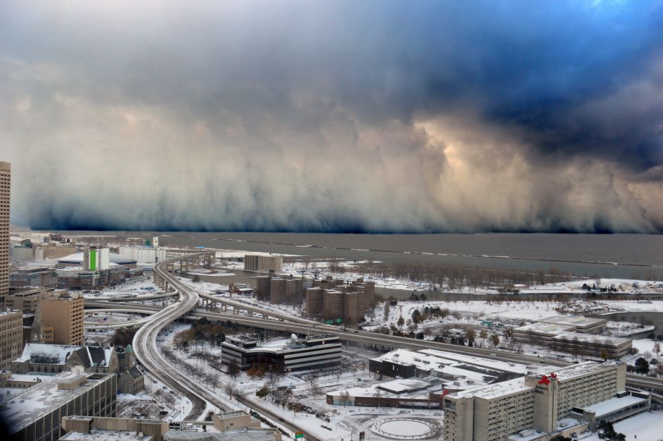 A wall of intense snowfall desending on the Buffalo Southtowns during the first of two historic back-to-back lake-effect snow events in November 2014. (Credit: Shawn Smith / NOAA Weather via Flickr CC BY 2.0)
Ice cover on the Great Lakes provides numerous recreational and economic opportunities, including ice fishing, snowmobile charters, and ice caves on the lakes. Unfortunately, declining ice cover and increasing related weather events due to climate change, as well as other environmental stressors, have put such opportunities at risk.
Historically, understanding winter weather has been difficult largely due to a lack of observations and, as a result, communities surrounding the Great Lakes have been left underprepared for extreme events.
As an associate research scientist and principal investigator at the Cooperative Institute for Great Lake Research (CIGLR) at the University of Michigan, Ayumi Fujisaki-Manome has dedicated her career to researching and improving climate forecasting methods as well as overseeing multiple monitoring projects in the Great Lakes over the past 14 years.
After receiving her PhD from the University of Tokyo, Fujisaki-Manome came to the United States for a postdoc at Princeton University. There, she studied theoretical ice and ocean interactions. Fujisaki-Manome’s passion for her overall research goal was secured during her second postdoc at the University of Michigan.
“My overall research goal is to improve the predictability of hazardous weather, ice, and ocean or lake events in order to support the community and their preparedness and resilience,” explains Fujisaki-Manome.
Ice Research on the Great Lakes and in Coastal Areas
Ice research can be demanding for researchers due to severe weather, often caused by lake effect snow wherein cold air moves over the Great Lakes, absorbing heat and moisture, causing the southern region of the basin to see increased cloudiness and precipitation. CIGLR’s ice research aims to understand these events by studying the interactions between ice, water, and weather.
Fujisaki-Manome’s research focuses primarily on ice distribution and thickness, spatial patterns, and water and air temperatures in the Great Lakes.
An example of some of Fujisaki-Manome’s most recent work was a collaborative CIGLR project that involved compiling over 140 years worth of air temperature data from various coastal stations in order to identify overall warming and a correlation to the Atlantic Multidecadal Oscillation.
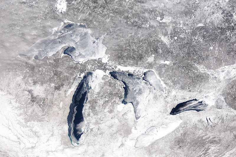
MODIS satellite image showing ice cover on the Great Lakes (88.7%), February 28, 2015. (Credit: NOAA Great Lakes CoastWatch)
In addition to her research with CIGLR, Fujisaki-Manome also works closely with scientists at the Great Lakes Environmental Research Laboratory on the development of an ice model for NOAA’s Great Lakes Operational Forecast System (GLOFS), which provides 5-day predictions of lake temperature, current, and water levels.
Traditionally, NOAA’s weather forecast model assumed lake surface conditions didn’t change over the forecast period. According to Fujisaki-Manome, this strategy fails to consider how changing lake conditions impact forecast accuracy.
Fujisaki-Manome elaborates, “[Dynamic forecasts are] pretty critical for lake effect snow cases because there’s a cold air mass moving over the lake, and lake conditions change pretty rapidly as cooling happens, ice forms, ice moves, and those changes are missed in traditional forecasting methods.”
Instead, CIGLR and NOAA implemented a technique that links the experimental GLOFS network and the weather prediction model to improve lake-effect snow predictions.
Ice Monitoring and Collaboration
Improving GLOFS’ model prediction accuracy relies on various monitoring methods that gather dynamic winter lake surface data. A popular method of ice monitoring is satellite data, so scientists can avoid working in harsh freezing environments.
“Satellite data is very, very helpful to monitor spatial patterns of ice cover.” However, Fujisaki-Manome warns, “It’s not as easy to estimate ice thickness based on satellite measurement.”
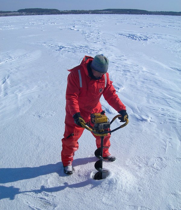
Other ice monitoring methods used to gather prediction data are in situ measurements, like classical ice auger sampling. Specifically, in Lake Erie’s Western Basin, shallow water ice profilers—lake/seafloor sensors that look up to measure ice thickness—collect valuable data.
Continuous research and further development of monitoring methods will ensure that GLOFS gathers accurate and verifiable data. Acquiring accurate predictions, particularly for a seasonal time scale and beyond, is challenging because the Great Lakes’ winter weather dynamics fluctuate yearly. Overall trends are seeing ice declines with large ups and downs over time, making it difficult to determine how the winter season will look three months in advance.
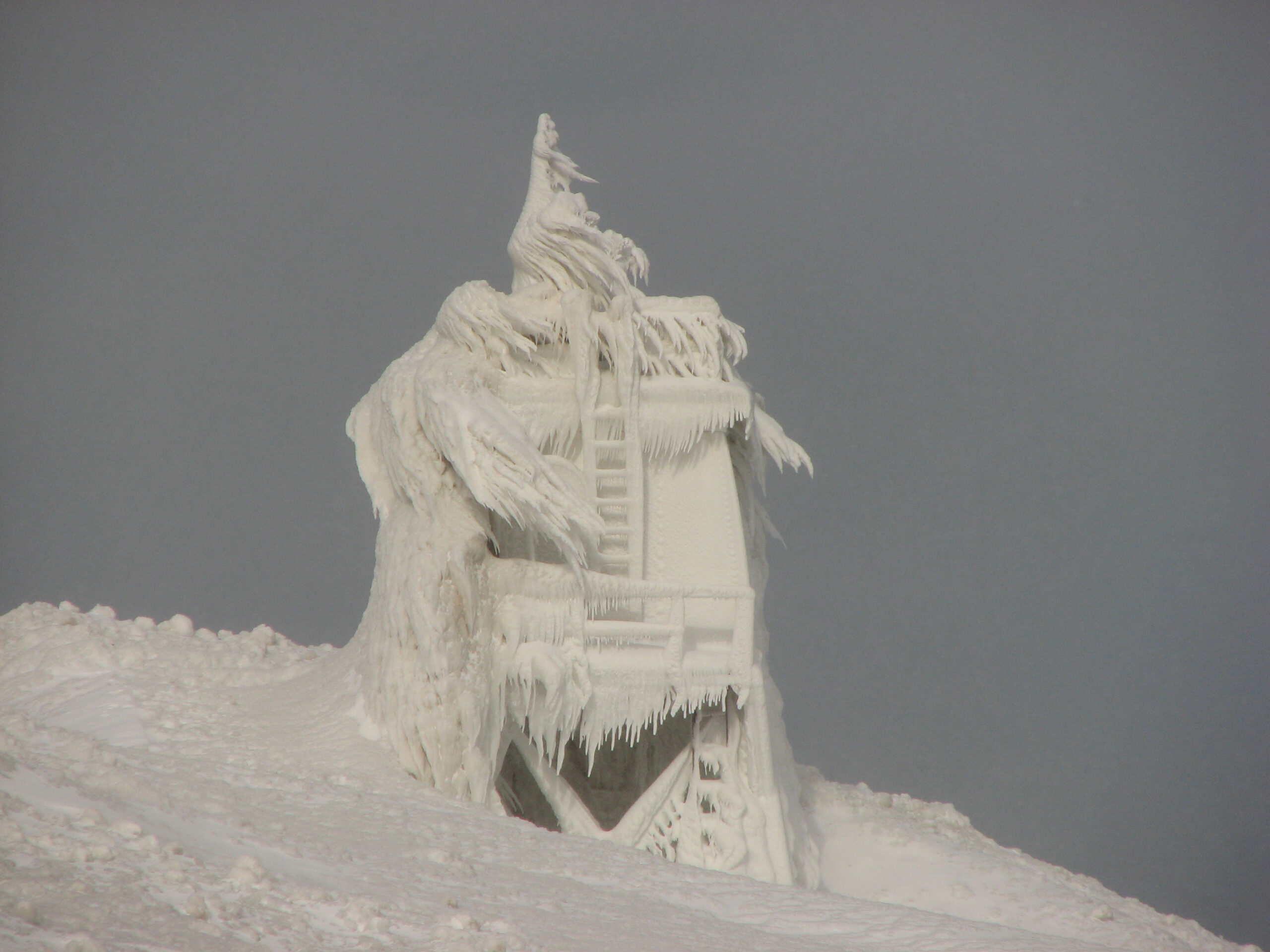
Grand Marais Observation Platform, Lake Superior. February 13, 2008. (Credit: NWS Marquette, MI. via Flickr CC BY-SA 2.0)
Researchers collect a lot of data and can prepare GLOFS’ interface, but they can’t always determine what users will enjoy the most. Collaborating with scientists from the Great Lakes Integrated Sciences and Assessment, the University of Michigan hosted a series of workshops, interviews, and focus groups, in order to help connect scientists and potential user groups.
Workshops started in 2019 with the U.S. Coast Guard, industry representatives, and NOAA scientists providing feedback on the original interface design. In 2021, researchers conducted additional interviews with the workshop participants to assess the newly redesigned model that integrated feedback from the earlier workshops. Notably, the new design included incorporating spatial coverage and wind on top of ice and weather information.
“I love working with people outside my area. In my institute itself, you know, it’s very interdisciplinary. There are ecologists, engineers, monitors, atmospheric scientists, physical oceanographers, etc. So, a lot of our work is collaborated, and I think it’s a strength,” explains Fujisaki-Manome.
Benefits of Ice Weather Forecasts
Ice weather prediction and monitoring have immense advantages for surrounding communities. Determining where and how much snow will fall is difficult, but warnings for unstable weather can help nearby residents prepare for possible dangers.
“Specifically for lake effect snow, it can cause utility damage, school closures, and bad traffic. There could be fatalities associated with these snow events,” stresses Fujisaki-Manome.
Accurately forecasting hazardous snow events prepares people living near the Great Lakes so they can appropriately evaluate lake effect weather events.
Along with predicting ice weather events, GLOFS’ data shows evidence suggesting the Great Lakes ice cover is decreasing. Declining ice can be just as hazardous as icy weather due to less ice cover, warming the water and releasing moisture, thus accelerating the lake effect.
“So there will be more lake effects that could be rain instead of snow. But if it is freezing rain, it’s more dangerous than snow. Freezing rains are dangerous, so there will be changes of all kinds. And I am not quite sure we are all prepared for that,” explains Fujisaki-Manome.
Less ice suggests future cultural and economic changes for those who rely on it to survive in the winter. An ice-free winter would mean that businesses would lose out on opportunities, and wintertime recreational activities that require ice would cease. For example, the Apostle Islands’ ice caves on Lake Superior rely on cold wind patterns to form correctly.
Ice fluctuations can also shape the way residents of ice-reliant regions spend the winter. From
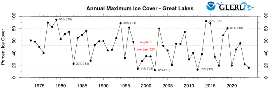
Record of annual maximum ice cover over the Great Lakes. (Credit: NOAA Great Lakes Environmental Research Laboratory)
2018-2021, Fujisaki-Manome conducted research on Alaska’s coasts and the Arctic Ocean, for better prediction of landfast ice, which is stable ice cover attached to the shore.
This ice is particularly important as many Alaskans rely on ice for transportation and hunting. Fujisaki-Manome and her fellows continue this research, focusing on engaging Alaskan boundary organizations and communities.
Ice predictions also impact the availability of global resources in marine ecosystems. In salty waters, sea ice formation contributes to deep water convection, essential oceanic iron supplies, and ventilation of deep water, which are all important for oceanic ecosystems.
Fujisaki-Manome’s Ph.D. study focused on the relationship between sea ice formation in the Sea of Okhotsk and the influence on the deep water that supplies oceanic iron to the intermediate water of the North Pacific Ocean. Declines in oceanic iron disrupt the entire marine ecosystem as the resource is essential to maintaining the ecological chain.
Conclusion: Global Reach of Ice Change
Changes in winter weather impact more than just the Laurentian Great Lakes–a variety of fluctuations in ice dynamics can be linked to climate change, particularly the frequency and impact of ice on coastal areas.
Impacted areas utilize forecasts to prepare the public for climate conditions and mitigate the risks of specific winter weather events. Forecasts such as GLOFS and the Alaska Coastal Ocean Forecast System (ALCOFS) are improving thanks to continual forecasting research by Fujisaki-Manome and fellow researchers.
In order to improve the accuracy, additional research on previous data trends and more expansive ice analysis is necessary to inform forecasting models. Developing advanced ice monitoring systems will help researchers acquire dynamic lake and sea conditions for more precise predictions.
Ice sampling in Green Bay, Lake Michigan. February 2009. (Credit: NOAA Great Lakes Environmental Research Laboratory via Flicker CC BY-SA 2.0)


0 comments