
Sargassum Surge: How Seaweed is Transforming our Oceans and Coastal Ecosystems
Until recently, Sargassum–a free-floating seaweed–was distributed throughout the Sargasso Sea, the north Caribbean Sea, and the Gulf of Mexico. But in the space of a decade, this seaweed has, as one scientist remarks, “Gone from a nonfactor to the source of a terrible crisis.”
Driven by climate change, anomalous North Atlantic Oscillation in 2009-2010 and a glut of anthropogenic pollutants, sargassum has proliferated.
Seasonally recurrent mats as deep as 7m now bloom in the “Great Atlantic Sargassum Belt” (GASB), which covers areas of the Atlantic from West Africa to the Caribbean Sea and Gulf of Mexico. Every year, millions of tons wash up along the shores of more than 30 countries.
Dr. Yanna Fidai is an Earth Observation and Remote Sensing Scientist at Plymouth Marine Laboratory in the UK. Inspired by the role environmental monitoring plays in understanding environmental change and improving management, much of her recent research has focused on sargassum.
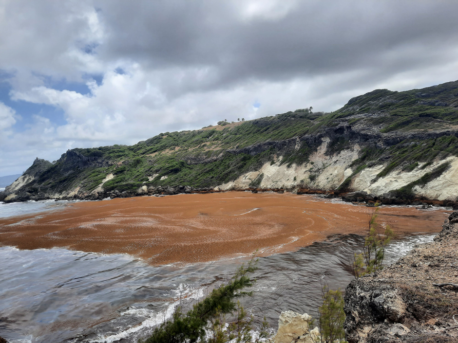
A Sargassum mat fills a bay in Barbados. (Credit: Yanna Fidai)
The Emergent Problem
Fidai explains that since 2011, “Sargassum has started blooming, proliferating and moving around the tropical Atlantic. There’s now lots in the Gulf of Mexico, in the Caribbean, down to the mouth of the Amazon River, across to the Gulf of Guinea, and just north of the mouth of the River Congo.”
While mats have historically provided a sanctuary for juvenile fish and migrating species in the open ocean, the super-sized accumulations of recent years–as big as “hundreds of kilometers”–now pose a threat to biodiversity, human health and the livelihoods of coastal communities.
In nearshore areas, sargassum can smother flora and fauna, including coral reefs and seagrass. Its accumulation and decomposition can increase turbidity and nutrient load, leading to eutrophication.
When washed up on beaches, its rapid decomposition releases toxic gases like ammonia, methane and hydrogen sulfide, which can contaminate drinking water via leaching of arsenic and heavy metals, posing a threat to human health.
An observational study in the Caribbean recorded almost 160 medical cases attributed to decomposing sargassum in a year, with patients suffering symptoms analogous to the toxidrome associated with acute exposure to hydrogen sulfide (H2S).
The socio-economic effects of sargassum landings are substantial and multifaceted, affecting community and commercial activity at the coast.
Discussing the subsistence lagoon fishing common off the West African coast, Fidai says, “People are unable to get their boats out because of the sargassum stacked on the beach. When they’re fishing, sargassum gets stuck in nets, engines, and propellers–so they’re working longer hours for less. It’s having an impact on local food, fish exports, and incomes.”
And in a region famed for its crystal seas and white sand beaches, the mats are affecting the tourism industry, too, disrupting visitors’ experiences and incurring a management cost for businesses. This could be especially damaging in the Caribbean, the global region most reliant on travel and tourism.
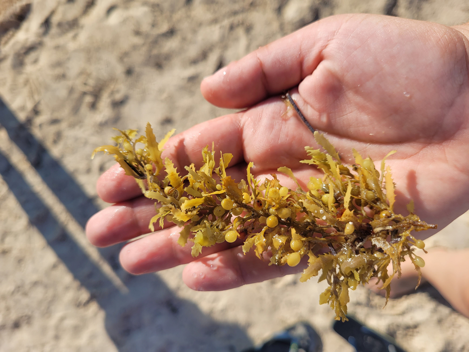
Sargassum fluitans III collected on a beach in Mexico. (Credit: Yanna Fidai)
Monitoring Sargassum with Remote Sensing
Fidai used a “combination of satellite and in-situ” measurements to investigate the movement of sargassum, which can be easily identified in satellite imagery because of its distinct brown pigment and movement patterns.
“Sargassum creates a unique, teardrop-like shape, with the round bit at the windward edge,” Fidai explains. “And then you’ve got windrows, which are more like stripes. You’ve got more isolated patches, but we can see the large ones very clearly in optical satellite imagery.”
Fidai’s research used imagery from the Moderate Resolution Imaging Spectroradiometer (MODIS), Sentinel-1, and Sentinel-2 satellites.
Sentinel-1 uses synthetic aperture radar to detect sargassum, and its microwave bands mean it can “see through clouds”–a useful feature when studying the tropical North Atlantic where there is “consistent cloud cover”–especially during hurricane season, Fidai adds.
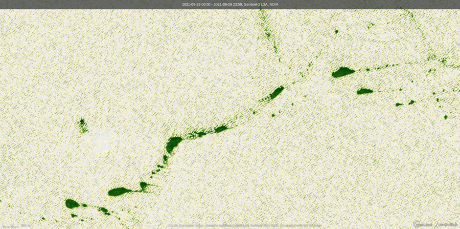
Satellite image of the Caribbean Sea (16.56595, -66.01014) taken by Sentinel-2, adjusted to show Normalized Difference Vegetation Index (NDVI), a measurement of green vegetation. In this image, floating sargassum can be clearly seen, with characteristic teardrop shapes indicating the direction of movement. (Credit: Modified Copernicus Sentinel Data, 2025 / Sentinel Hub)
Fidai explains that she needed a low-cost method of deploying in-situ GPS to validate satellite data. Developed during the COVID-19 pandemic using accessible materials and tested in her bathtub at home, 10 GPS spot trace trackers were deployed by local contacts on sargassum mats in the Caribbean Sea.
The in-situ trackers provided valuable hourly data on mat movement. She notes, “This means we can confidently say that it’s the same mat we’re seeing in the different imagery. Sentinel-2 has a roughly five-day revisit time, so in that gap, we don’t know if we’re looking at the same mat.”
Fidai continues, “We also got to see one mat moving from Barbados to land on the beach in St Lucia really quickly. Calculating the speed of movement is helpful in forecasting, to enable communities, islands, and local governments to prepare for any inundations.”
Local communities can also be mobilized to support in-situ monitoring. Fidai supported the University of Southampton’s sargSnap program, a youth-led citizen science project in Ghana and Mexico, which aims to photograph landed sargassum at key locations. Projects like this educate and empower communities while providing scientists with data to improve estimates.
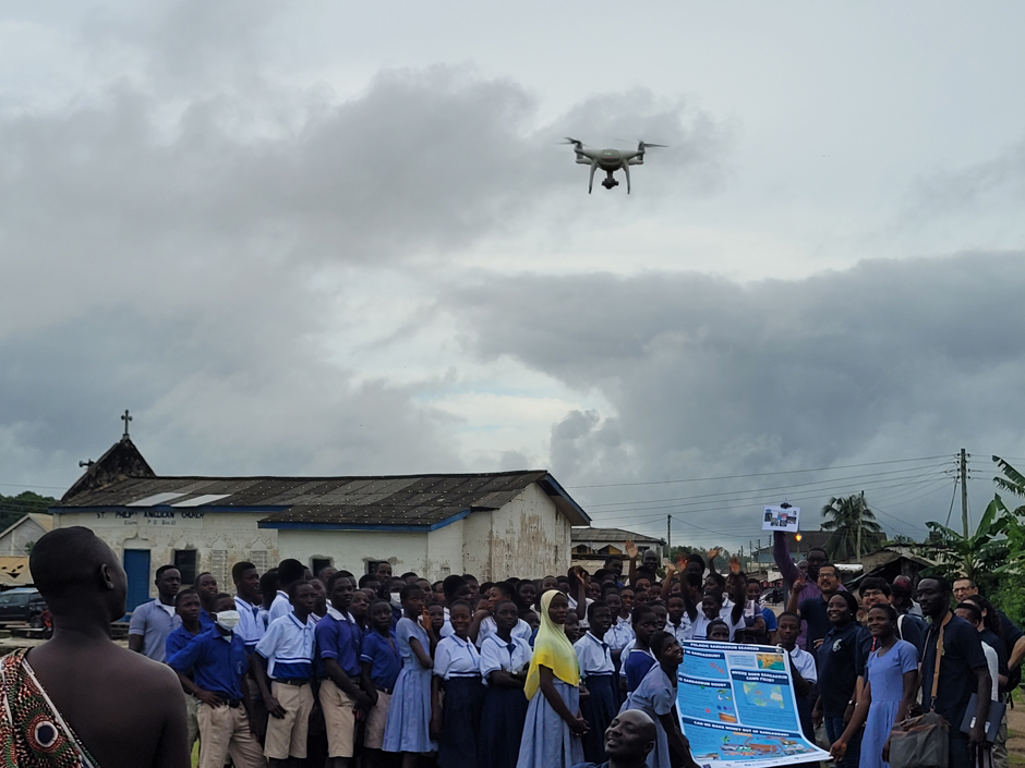
School children in Ghana watch a drone launched for surveys during a More than Maps citizen science workshop teaching them environmental monitoring skills. (Credit: Yanna Fidai)
Forecasting Sargassum
In January 2025, sargassum concentrations in the eastern and western Atlantic surpassed the 75th percentile compared to recent years. 2025 is predicted to be another major Sargassum year, but forecasting landings is complex.
“Sargassum is mostly moved by currents, but there is an estimated 2 to 5% impact of windage on sargassum movements,” Fidai explains.
In the North Atlantic, major circulatory systems, including the Caribbean Current, North Brazil Current System, and Gulf Stream, drive sargassum’s pelagic movement.
“We can model with some accuracy, but to validate the models, having in-situ data to track the mats is really useful, so we can get the ratio of wind and currents influencing the movement of sargassum,” Fidai states.
There are already a number of systems that provide predictions of sargassum loads, including a quarterly, Caribbean-wide bulletin, the National Oceanic and Atmospheric Administration (NOAA) Experimental Weekly Sargassum Inundation Report, and the non-profit Sargassum Monitoring program.
Fidai is clear that to ensure community preparedness, forecasting needs to be tailored for management purposes, stating, “While it’s helpful to have a good estimation of how much sargassum there’s going to be over the next few months and where might be worst hit, it’s not as useful as saying, this beach in two weeks is going to get 5,000 tons of sargassum, because the reaction is proportional.”
Forecasting is likely to become ever more important as coastlines continue to be impacted by record-breaking amounts of sargassum, and ongoing environmental monitoring will play a vital role in bridging the gap between scientists and affected communities.
Tracking mats using satellite imagery. Panels on the left (A-C) show the pixels identified as sargassum in satellite imagery and the change in morphology as it travels. The position of the mat is indicated in the map on the right. (Credit: Yanna Fidai)
Sargassum Opportunities
Despite the negatives associated with sargassum, Fidai emphasizes, “There is room for economic opportunity as much as there is cost.”
Considerable research has already documented the possibilities of using the seaweed as a resource, including as a fertilizer and raw material for biofuels and pharmaceuticals.
Fidai used drone surveys and field spectrometers to explore the valorization potential of sargassum landings in Barbados and Ghana and assess the possibility of developing a remote identification protocol.
“If from the spectral signature we can determine what pigments and biochemical compounds are in the landed sargassum–such as alginates, mannitol, sugars, and different proteins–this could potentially lead to sargassum being harvested for use,” Fidai says.
“This is really important because many of the countries most affected by sargassum in terms of fishing and tourism are developing. So for them to be able to view Sargassum as a resource and to monetize it would be really useful,” she adds.
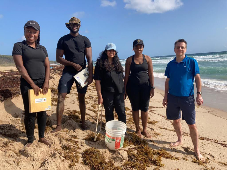
Fidai (pictured center) working with Colleagues from the University of West Indies and the University of Southampton to survey landed sargassum in Barbados. (Credit: Yanna Fidai)
An Uncertain Future for Sargassum
Looking to the future, research on the fate of sargassum in the context of climate change is inconclusive. “The ocean is in a constant state of chaos,” Fidai observes, “so while we know key characteristics, they can also change.”
Sargassum growth rate is temperature-dependent. While warming sea surface temperatures may initially increase nutrient uptake rates and lead to proliferation, over the longer term, multidecadal ocean warming may surpass sargassum’s physiological threshold, resulting in decline.
Additionally, warming is expected to critically change ocean circulation patterns–the main driver of sargassum movement–potentially facilitating or precluding the dispersal of this species and others to new regions.
The Role of Environmental Monitoring
To unravel these changes, satellite remote sensing and in-situ monitoring are indispensable tools for the large-scale monitoring of a large-scale problem.
The creation of a continuous dataset that isn’t geographically biased–previous research has often neglected the impact of sargassum on West African coastlines–and continued development of long-term records on the frequency, magnitude, and finer-scale movements will be vital to forecasting in a changing world.
Sargassum poses a transboundary risk, and interdisciplinary environmental monitoring is one of the best tools we have to understand its movement, manage its impacts, and potentially reap its benefits.
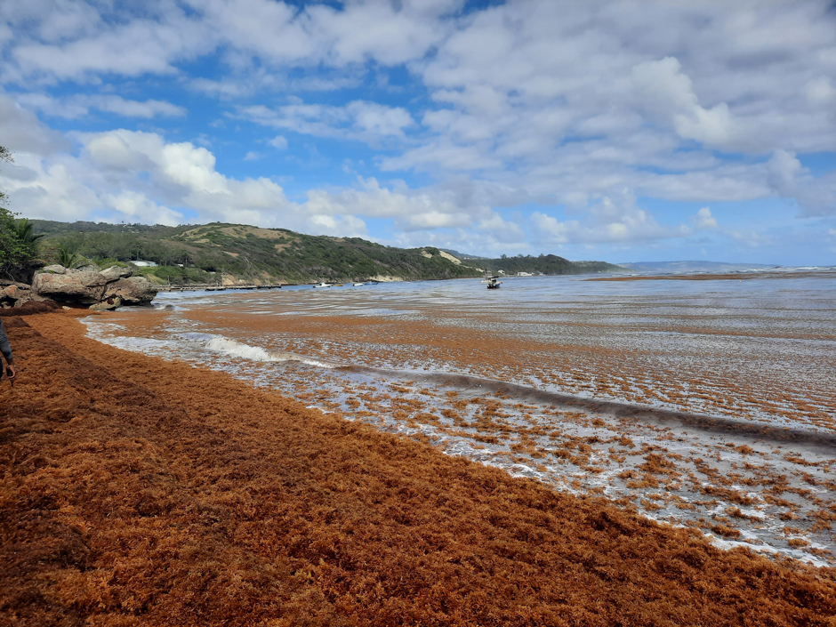
Sargassum chokes a popular fishing beach in Barbados. (Credit: Yanna Fidai)


0 comments