State’s scientists connect public to Puget Sound with aerial photos and water data

The state scientists who track water quality in Puget Sound in Washington State have found a way to capture something that neither their high-tech sensors nor laboratory analysis could: the public’s attention.
Puget Sound is a complex estuary system made up of several branching channels, basins and islands. Four times a month, the Washington State Department of Ecology charters a float plane as a cost-efficient way to hop between 40-odd water sampling stations spread across the Sound’s roughly 1,000 square miles.
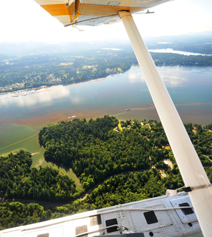
In 2011, Christopher Krembs, lead oceanographer with the ecology department, realized that the plane had an empty seat on its flights over the Sound to and from Olympia where it picks up monitoring equipment. Now Krembs occupies that seat once a month, making good use of his love for photography.
“It’s my highlight of the month,” Krembs said. “It gets me out of cubicle land.”
And it gets the department’s Marine Water Monitoring Unit some compelling outreach material at no extra cost. Each flight, Krembs shoots up to 500 aerial photos of the Sound, capturing both the beautiful scenery and important environmental events like algae blooms, oil spills, clustering jellyfish and sediment plumes.
Within two days of the flight, the best handful of photos are packaged with the monitoring program’s most recent and long-term data and released online as the “Eyes Over Puget Sound” report. With over half a million downloads in the last year and a half, Krembs said he thinks they’ve struck a chord with the public.
“The nice thing about these images is we don’t need to say very much,” he said. “You look at them and you get a sense of scale and of intensity of these processes that are happening out there.”
And pairing the pictures with both very recent and long term data helps create context that helps people follow along.
“You can tell a story,” he said. “We realized when you tell a story, people really get interested, much more than if you just deliver plain data or graphs.”

The department’s monitoring flights lower a Sea-Bird CTD into Puget Sound (Credit: Washington Department of Ecology)
During the department’s sampling flights, the float plane lands at a station and the crew lowers a sensor package from the surface to the bottom, up to 260 meters deep at some locations. The sensors, which include Sea-Bird CTD and WET Labs ECO FLNU units, capture a vertical profile of variables like temperature, salinity, dissolved oxygen, fluorescence and turbidity. Several sample bottles trigger at predetermined depths, collecting water that will later be analyzed for nutrients and pigments.
The program also collects data from five permanent moored stations. These sites are equipped with another suite of Sea-Bird Electronics sensors, though they aren’t covered by as many sensors as the flight-based sites. Nor are they given the in-depth chemical analysis.
But while monthly flights cover many more parameters, they’re only delivering snapshots. The continuous, high-resolution data from moorings help reveal processes like the transport of low-oxygen water over critical locations and between basins.
“It’s like monitoring the heartbeat or the blood pressure,” Krembs said of the moored stations. “Our monthly sampling is more like a blood draw where you do a full analysis of your hormone levels and everything that goes with it.”
Puget Sound is a tidally driven estuary and is highly influenced by the Pacific Ocean. For example, summertime upwelling from the ocean can bring low-oxygen, high-nutrient water into the sound. Meanwhile, the sound’s increasingly peopled shores also have an impact on nutrient levels. Long-term datasets help scientists distinguish between natural variability and human signals.
“The holy grail is to separate them from each other,” Krembs said. “That ocean can be a big gorilla, so you have to understand that gorilla in your equation in order to understand the human impact.”

Krembs’ aerial photos give the public a new perspective on Puget Sound (Credit: Washington Department of Ecology)
Information collected by state agencies often takes a long time to get to the people, Krembs said. By pushing to get fresh data out the door within two days of the monitoring flights, Eyes Over Puget Sound is helping change that. And sprucing up the data with photos from 2,500 feet helps it hit home.
“People see now their own backyard from a very different perspective,” Krembs said. “They start to ask more questions. They learn to observe the system with very different eyes. So it’s creating awareness”


0 comments