Studying Chesapeake Bay Shallows To Preserve Key Habitats

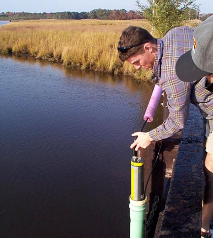
A field biologist with the Maryland Department of Natural Resources deploys a YSI water quality sonde. (Credit: Brian Smith / Maryland Department of Natural Resources)
Chesapeake Bay is the largest estuary in the United States and one of the most productive bodies of water in the world. This is especially true for its shallow waters, where underwater grass beds serve as habitats and nursery grounds for juvenile fish and other aquatic life.
Because of the roles that these areas play in supporting the bay’s health, managers with the Maryland Department of Natural Resources are understandably interested in keeping tabs on how their conditions change over time.
“…Maintaining good water quality in these habitats is crucial to sustaining viable populations of Maryland’s living resources,” said Brian Smith, program manager of monitoring integration with the DNR.
To do this, Smith and other scientists at the DNR have set up multiple monitoring stations around the bay. Seven of these are NexSens 3100-MAST systems that collect readings from YSI water quality sondes and then transmit them back to researchers via cellular telemetry.
“Although sites have varied somewhat from year to year, all of our systems are deployed in the shallow waters of the Chesapeake Bay and tidal tributaries in Maryland,” said Smith. He adds that one is deployed in the Corsica River near Centreville, Maryland, while another is located in Little Monie Creek, which is part of the Chesapeake Bay National Estuarine Research Reserve System.
At each of the seven sites, data are logged every 15 minutes on parameters like water temperatures, salinity, pH, dissolved oxygen levels, turbidity and chlorophyll concentrations. In the short-term, Smith says these high-resolution data can illustrate the impacts of extreme events like hurricanes, high flows and sanitary sewer overflows.

A field biologist with the Maryland Department of Natural Resources records measurements of water quality parameters. (Credit: Maryland Department of Natural Resources)
“In addition to characterizing the health of shallow water habitats, continuous monitoring information is also used to better understand ecosystem processes and the short-term impacts of extreme events…along with seasonal changes in shallow and open water environments,” said Smith.
All of the data collected are posted online to the Eyes on the Bay website that enables anyone to access data from monitoring stations around Maryland. On this site, which is currently undergoing some routine maintenance, it’s possible to see how parameter readings have changed over time. These can be compared to goals that the Maryland DNR has set for the different waterways.
The most important parameters that are tracked, Smith says, are dissolved oxygen, turbidity and chlorophyll. These are used to assess Chesapeake Bay water quality criteria that have been established through the Chesapeake Bay Program, a regional partnership of federal, state and citizen groups leading efforts to restore the bay.
“Criteria for these parameters define the water quality conditions necessary to sustain and protect the habitat and living resource communities associated with each waterway, including migratory fish spawning and nurseries, open- and deep-water fish, and shellfish,” said Smith. “These parameters are also used to assess shallow water bay grass habitat and to identify areas of the bay and tidal tributaries where bay grasses can be restored.”
Reports of the data help managers to determine if certain areas should be seen as improved or degrading habitats. The information has also helped officials see how water quality has changed following the implementation of best management practices (BMPs).
“One of the more interesting findings through our monitoring is that there appears to be a lag time in the improvement of water quality conditions in response to BMPs. In other words, conditions do not immediately improve when BMPs that reduce the amount of nutrients entering waterways are implemented,” said Smith. “Thus, to accurately gauge the efficacy of various BMPs, it may be necessary to monitor the response of waterways over a time span of many years.”
Top image: A field biologist with the Maryland Department of Natural Resources deploys a YSI water quality sonde. (Credit: Maryland Department of Natural Resources)


0 comments