My Cart
You have no items in your shopping cart.
Overview
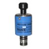
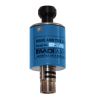
The Aanderaa 5217 Tide Sensor is a compact, fully integrated sensor for measuring tidal conditions. The sensor is designed to be mounted on the Aanderaa SeaGuardII top-end plate or in other measurement systems using the RS-232 interface. The tide measurement is an average of the hydrostatic pressure measured over a time period of 10 seconds to 8 minutes (integration time is configurable by the user). The update interval is between 1 second and 255 minutes.
Mechanics
The Tide sensor output parameters are Tide Pressure, Tide Level, Pressure and Temperature. Tide levels are preliminary, internally calculated estimates based on fixed, user-selectable values of atmospheric pressure and water salinity. Compensation for actual atmospheric pressure and salinity can be post-processed if such data is available. Tide Pressure is an average of hydrostatic pressure over the integration time.
Data Storage
Since all calibration and temperature compensation data are stored inside the sensor, the parameters are, by default, presented directly in engineering units without any external calculation. The sensor also provides raw data on the pressure and temperature measurements.


Until recently, Sargassum –a free-floating seaweed–was distributed throughout the Sargasso Sea , the north Caribbean Sea, and the Gulf of Mexico. But in the space of a decade, this seaweed has, as one scientist remarks , “Gone from a nonfactor to the source of a terrible crisis.” Driven by climate change, anomalous North Atlantic Oscillation in 2009-2010 and a glut of anthropogenic pollutants, sargassum has proliferated. Seasonally recurrent mats as deep as 7m now bloom in the “Great Atlantic Sargassum Belt” (GASB), which covers areas of the Atlantic from West Africa to the Caribbean Sea and Gulf of Mexico. Every year, millions of tons wash up along the shores of more than 30 countries . Dr.
Read More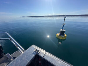
According to the National Oceanic and Atmospheric Administration ( NOAA ), the Great Lakes have more miles of coastline than the contiguous Atlantic and Pacific coasts combined and contain 20 percent of the world's freshwater, making it a critical region to protect and conserve. Continuous monitoring and data-informed resource management are key components of managing waters in the region. Hayden Henderson, a research engineer with the Great Lakes Research Center (GLRC), designs and deploys monitoring platforms throughout the Great Lakes. With a background in environmental engineering, Henderson enjoyed the challenge of creating systems and making them work to obtain difficult, remote measurements.
Read More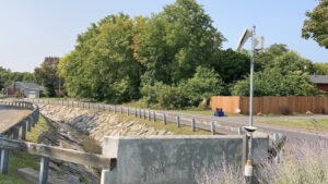
Meadowbrook Creek in Syracuse, New York, has been monitored by Syracuse University (SU) faculty and students for over a decade. Originally established by Dr. Laura Lautz in 2012, the early years of the program focused on collecting grab water samples for laboratory analysis and evaluating the impact of urban land use, human activities, and natural processes on water resources. Tao Wen , an Assistant Professor in SU’s Department of Earth and Environmental Sciences, took over the program in 2020 and upgraded the existing systems to include 4G modems that allowed for real-time data viewing. [caption id="attachment_39339" align="alignnone" width="940"] An overview of the Fellows Ave monitoring station along Meadowbrook Creek.
Read More© 2025 Fondriest Environmental, Inc. | Questions? Call 888.426.2151 or email customercare@fondriest.com