
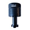
Aanderaa ZPulse Doppler Current Sensors
Features
- ZPulse technology improves data quality, sampling speed and reduces power consumption
- Built in solid state three axis tilt compensated compass
- Smart sensor for easy integration on the SeaGuardII platform or 3rd party data loggers
- Expedited repair and warranty service
- Lifetime technical support
- More
Overview
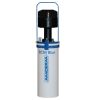
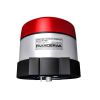
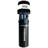
The Aanderaa ZPulse Doppler Current Sensor (DCS) is a single-point current sensor designed for use with the Aanderaa SeaGuardII platform or external measurement systems using the RS-232 interface. The DCS measures in both directions on each axis and is insensitive to disturbance from vortex speeds around the sensor itself and the mooring line when the forward ping feature is enabled. Multi-frequency acoustic technology improves data quality and sampling speed as well as reduces power consumption.
Design
It is designed for commercial as well as research use. The DCS sensors are based on the backscatter acoustic Doppler principle. The solid-state sensor is well suited for monitoring low current speeds due to its lack of moving parts. Because the sensor starts measuring 0.4 to 1.0 meters from the instrument, the effect of marine fouling and local turbulence is minimized.
Select Options


In The News

Sargassum Surge: How Seaweed is Transforming our Oceans and Coastal Ecosystems
Until recently, Sargassum –a free-floating seaweed–was distributed throughout the Sargasso Sea , the north Caribbean Sea, and the Gulf of Mexico. But in the space of a decade, this seaweed has, as one scientist remarks , “Gone from a nonfactor to the source of a terrible crisis.” Driven by climate change, anomalous North Atlantic Oscillation in 2009-2010 and a glut of anthropogenic pollutants, sargassum has proliferated. Seasonally recurrent mats as deep as 7m now bloom in the “Great Atlantic Sargassum Belt” (GASB), which covers areas of the Atlantic from West Africa to the Caribbean Sea and Gulf of Mexico. Every year, millions of tons wash up along the shores of more than 30 countries . Dr.
Read More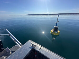
Great Lakes Research Center: Designing Targeted Monitoring Solutions
According to the National Oceanic and Atmospheric Administration ( NOAA ), the Great Lakes have more miles of coastline than the contiguous Atlantic and Pacific coasts combined and contain 20 percent of the world's freshwater, making it a critical region to protect and conserve. Continuous monitoring and data-informed resource management are key components of managing waters in the region. Hayden Henderson, a research engineer with the Great Lakes Research Center (GLRC), designs and deploys monitoring platforms throughout the Great Lakes. With a background in environmental engineering, Henderson enjoyed the challenge of creating systems and making them work to obtain difficult, remote measurements.
Read More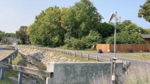
Monitoring Meadowbrook Creek: Real-Time Data Collection in an Urban Creek
Meadowbrook Creek in Syracuse, New York, has been monitored by Syracuse University (SU) faculty and students for over a decade. Originally established by Dr. Laura Lautz in 2012, the early years of the program focused on collecting grab water samples for laboratory analysis and evaluating the impact of urban land use, human activities, and natural processes on water resources. Tao Wen , an Assistant Professor in SU’s Department of Earth and Environmental Sciences, took over the program in 2020 and upgraded the existing systems to include 4G modems that allowed for real-time data viewing. [caption id="attachment_39339" align="alignnone" width="940"] An overview of the Fellows Ave monitoring station along Meadowbrook Creek.
Read More