
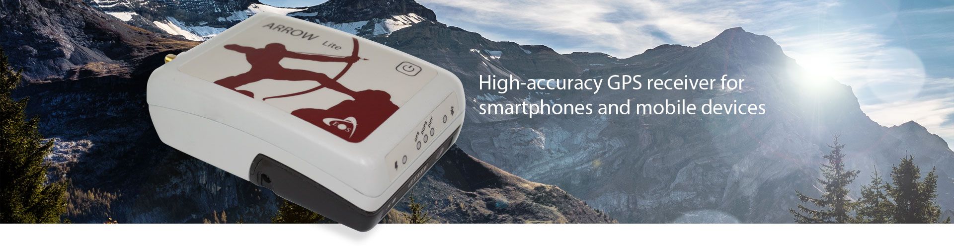
Eos Arrow Lite GPS Receiver
The Eos Arrow Lite is a high-accuracy GPS receiver for smartphones, tablets, or notebook computers.
Features
- 100% Android, iOS, Windows compatible
- 60cm real-time accuracy using free SBAS
- Supports Esri and other Mobile GIS software
- Free ground shipping
- Expedited repair and warranty service
- Lifetime technical support
- More
Work Where Other Receivers Can’t
The Arrow Lite was explicitly designed with GIS users in mind. It squeezes more accuracy from GPS SBAS corrections than any other receiver in the world. With its patented technology, use the Arrow Lite under trees, around buildings and in rugged terrain where other receivers will fail to deliver. No post-processing is required.
High-Accuracy GPS Receiver
The Arrow Lite is designed specifically to use with various mobile devices, including smartphones, tablets or notebook computers. The Arrow Lite incorporates rock-solid, wireless Bluetooth technology that works with Android, iOS or Windows devices, making it obsolete-proof.
Choice of Mobile GIS Software
The Arrow Lite feeds 1cm RTK accuracy to every app on Android or iOS device, including Google or Apple maps. Esri Collector/ArcPad/ArcMobile, Fulcrum, AmigoCloud, TerraFlex, MapItFast, GeoJot, iCMTGIS, the Arrow 200 works seamlessly with all of them and many more mapping apps.
Real-time, Worldwide Accuracy
The Arrow Lite uses the free GPS SBAS corrections available in each geographical region: WAAS in North America, EGNOS in Europe and North Africa, GAGAN in India, and MSAS in Japan to provide 60cm real-time accuracy. For South America, Australia and Central and South Africa, where free SBAS is not available, Eos has partnered with OmniSTAR to offer real-time, sub-meter accuracy.
- (1) Arrow Lite receiver with Arrow Smart Battery Pack
- (1) L1 GPS Precision Antenna
- (2) Antenna Cables
- (1) Soft hat for Antenna
- (1) Nylon Carrying Case (belt clip & shoulder strap)
- (1) 12V International Power Supply for Arrow Smart Battery
- (1) USB Data Cable
Select Options


In The News
Eos Arrow receivers give GIS pros real-time data, solid connectability
For pros working in mapping, surveying and other GIS fields, quick, precise data are a must. And the key to getting those data is getting the right receiver. As a result, many turn to high-accuracy, multi-constellation receivers like the Arrow series built by Eos Positioning Systems. The series includes the Eos Arrow Lite GPS Receiver, Eos Arrow 100 GNSS Receiver and Eos Arrow 200 L1/L2 GNSS Receiver. The receivers are popular for many reasons: They have the flexibility to use multiple satellite constellations, offer real-time data transmission capability and can connect to any device via Bluetooth. The Arrow receivers use the United States’ GPS constellation of satellites, but they can just as easily link up with Russia’s GLONASS, China’s Beidou and Europe’s Galileo.
Read More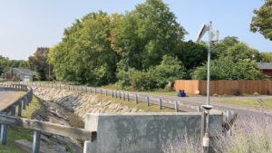
Monitoring Meadowbrook Creek: Real-Time Data Collection in an Urban Creek
Meadowbrook Creek in Syracuse, New York, has been monitored by Syracuse University (SU) faculty and students for over a decade. Originally established by Dr. Laura Lautz in 2012, the early years of the program focused on collecting grab water samples for laboratory analysis and evaluating the impact of urban land use, human activities, and natural processes on water resources. Tao Wen , an Assistant Professor in SU’s Department of Earth and Environmental Sciences, took over the program in 2020 and upgraded the existing systems to include 4G modems that allowed for real-time data viewing. [caption id="attachment_39339" align="alignnone" width="940"] An overview of the Fellows Ave monitoring station along Meadowbrook Creek.
Read More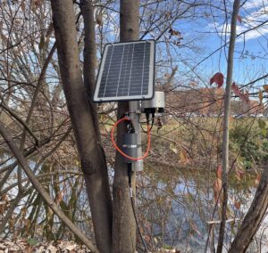
Lancaster County Makes the Switch to Real-Time Water Quality Monitoring Systems
Continuous data collection in Lancaster County, Pennsylvania, started about 5 years ago, and the county will be making a major upgrade over the next year—switching from relying solely on the internal storage of water quality sondes to telemetry units that enable real-time data viewing. [caption id="attachment_39295" align="alignnone" width="940"] The first telemetry unit was installed at LCCD along Little Conestoga Creek. (Credit: Tyler Keefer / LCCD) [/caption] Telling Lancaster County's Story Through Data Since the Lancaster County Conservation District started monitoring county waterways, the goal has remained the same, according to Amanda Goldsmith, Watershed Specialist for the Watershed Department.
Read More