
Eos Skadi Gold RTK GNSS Receiver
Features
- Works with SBAS, RTK networks, Atlas subscriptions, and Galileo HAS
- Optional Skadi Tilt Compensation captures points quickly without having to level a survey range pole
- Compatible with Skadi Smart Handle for Invisible Range Pole and Extensible Virtual Range Pole features
- Free ground shipping
- Expedited repair and warranty service
- Lifetime technical support
- More
Overview
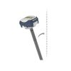
The Skadi Gold is the most advanced, accurate, and flexible receiver offered by Eos Positioning Systems. With support for all GNSS constellations, frequencies, signals, and corrections, you obtain unmatched accuracy and productivity in the most challenging environments. Even in areas with poor cellular coverage and physical obstructions, the Skadi Gold retains its accuracy thanks to the SafeRTK feature. The Skadi Gold GNSS receiver includes an integrated antenna and hot-swap, all-day battery.
To boost your productivity, take advantage of Skadi Tilt Compensation and collect points without “bubbling up” your survey range pole. Moreover, the Skadi Standard Handle can be upgraded to the Skadi Smart Handle for even more robust productivity and safety features, including the Invisible Range Pole for continuous elevations to the ground and the Extensible Virtual Range Pole for remotely capturing short-distance assets on the ground and in trenches.
Skadi Tilt Compensation
When you activate Skadi Tilt Compensation, you eliminate the need to level your antenna while performing RTK data collection on a range pole. With Skadi Tilt Compensation activated, you introduce only .3 mm (.01 inch) of inaccuracy per degree of tilt.
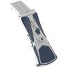
Skadi Smart Handle
The Skadi Smart Handle is a physical upgrade to your included Skadi Standard Handle. The smart handle features two exciting and powerful features. These features include the following:
Invisible Range Pole
The Invisible Range Pole is an innovative approach to bringing the benefits of a traditional survey range pole into your hand without the cumbersome physical weight. With the Invisible Range Pole feature, you carry a virtual gimbal that keeps you plumb to the ground. Raise, lower, or tilt the receiver, your elevation to the ground is continuously computed below the Skadi receiver in your hand, thanks to the exciting combination of LiDAR and MEMS technologies.
Extensible Virtual Range Pole
This exciting and innovative feature allows you to extend the reach of your data collection beyond the position you physically occupy. Using a built-in green laser pointer, now you can “shoot” short-distance assets on the ground while retaining high accuracy. This is particularly useful for assets in trenches and similar environments. The Extensible Virtual Range Pole has an approximate range of about seven meters (23 feet) in bright sunlight conditions (performance may vary based on target reflectivity).
- Skadi Gold GNSS Receiver with Integrated Antenna
- Pole Mounting Plate for Skadi Series
- Skadi Standard Handle (upgradable to Skadi Smart Handle)
- Phone Mounting Bracket for Skadi Series Handles
- Tablet Mounting Bracket for Skadi Series Handles
- Skadi Series Li-Ion Battery Pack
- USB-C Power Block
- USB-C Cable
- Skadi Series Hardshell Case
Select Options


In The News

Three Decades of Research at Acton Lake
A multi-disciplinary team at Miami University, Ohio, has been studying the environmental change at Acton Lake for over three decades. Using three different NexSens buoys over this time, the team has an incredible archive of data that is helping build a picture of Acton’s past, present, and future. Until recently, a NexSens CB-50 buoy was used alongside other environmental monitoring at Acton Lake. In May 2025, the Miami team deployed a new XB-200 buoy , future-proofing their ongoing monitoring using real-time buoy systems. Acton Lake, a small hypereutrophic reservoir in southwest Ohio, covers 2.4km² and has a maximum depth of about 8m. The dam was built in 1956, and the lake has a large agricultural watershed.
Read More
Source Water Monitoring in Albany, New York: Tracing Water Quality throughout Tributaries
Thousands of US cities pull their drinking water from natural source waters like reservoirs, rivers, and streams, making overall watershed health a key consideration for water providers. In Albany, New York, the Albany Department of Water and Water Supply delivers drinking water to over 100,000 residents as well as monitors and manages the larger drinking water supply watershed. Hannah Doherty, Environmental Specialist at the Albany Department of Water and Water Supply , spends her days working with a small team to monitor the drinking supply and the connected water bodies. Doherty explains, “We’re the first to encounter the water that ends up being the drinking water.
Read More
Wildfire Prevention in the Sierra Nevada Region with the Yuba Watershed Institute
Though recent wildfires have sparked new conversations about wildfire management and response, groups like the Yuba Watershed Institute have been monitoring the forests and water resources of the Sierra Nevada region for decades, managing approximately 5,000 acres of land with the Bureau of Land Management (BLM) and about 7,000 acres in private land partnerships. The goal of the Institute is to work with local communities and land agencies to improve watershed and forestry management through informed practices and public outreach. The goals of the Yuba Watershed Institute are three-fold: Improve the ability of fire suppression agencies like the California Department of Forestry and Fire Protection ( CAL FIRE ) and the US Forest Service.
Read More