Scientist-tested Equipment
Instrument Testing:
Field-approved Products
Field-approved Products
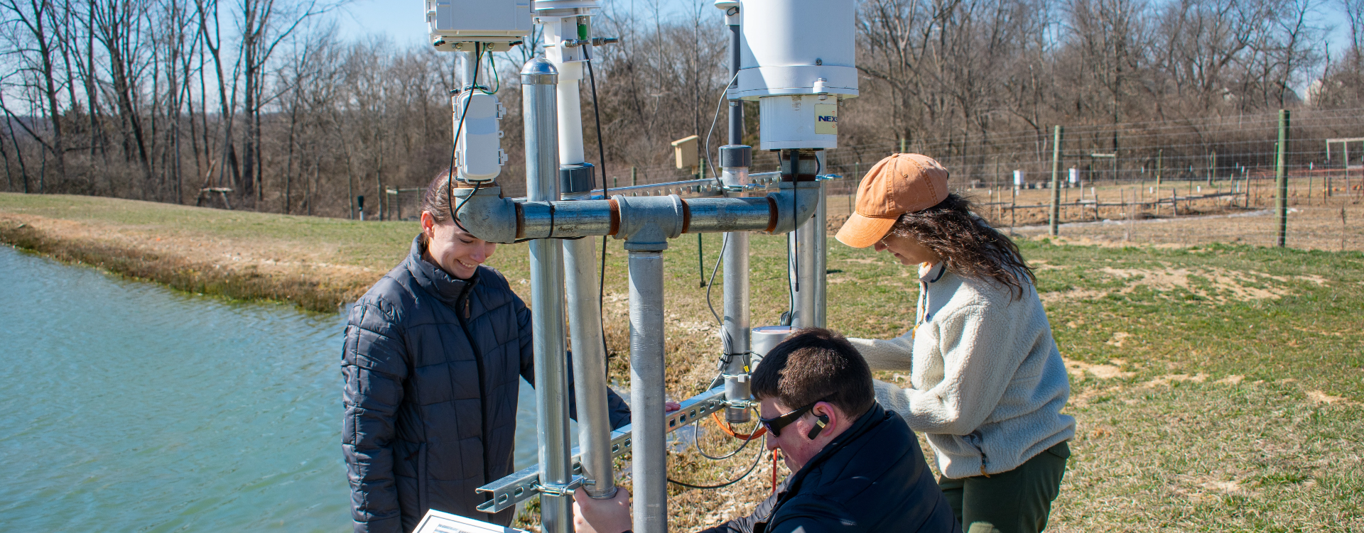
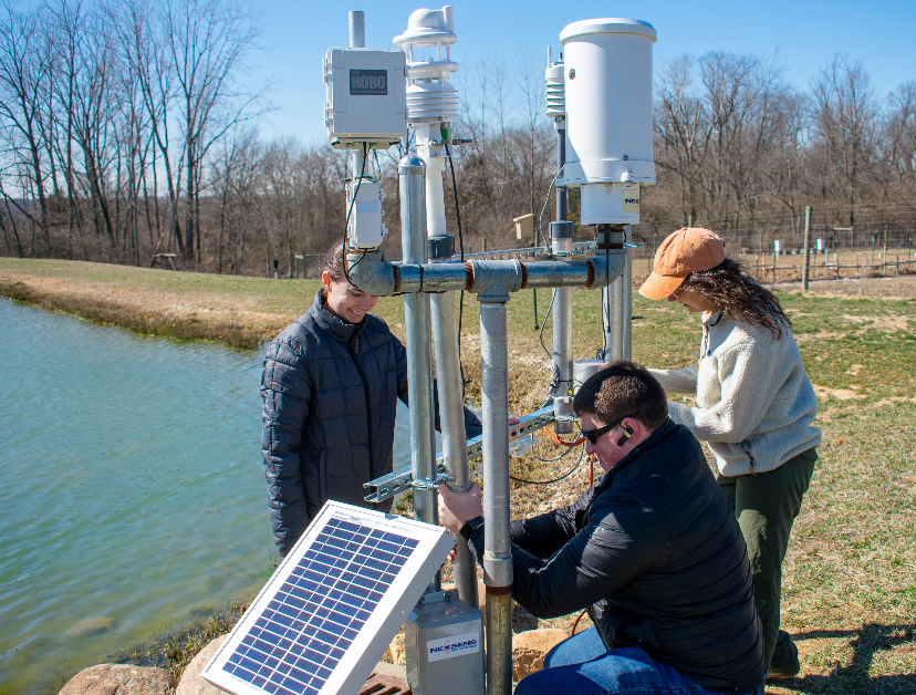
Scientists at Fondriest Environmental use the Field Station to study and test a wide variety of environmental monitoring instruments. The real-time data station collects long-term weather and water quality data to monitor changes over time. Industry-standard sensors are used to compare with newer instruments for testing purposes. The scientists go through numerous steps to test and ensure the instrument’s accuracy, durability, and reliability from out-of-the-box to the download of the first data set.
Discover more about the many instruments tested by the Fondriest Science Team below!
Discover more about the many instruments tested by the Fondriest Science Team below!
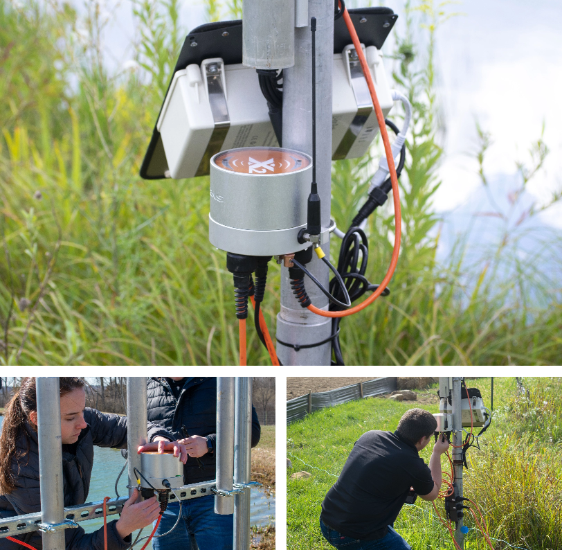
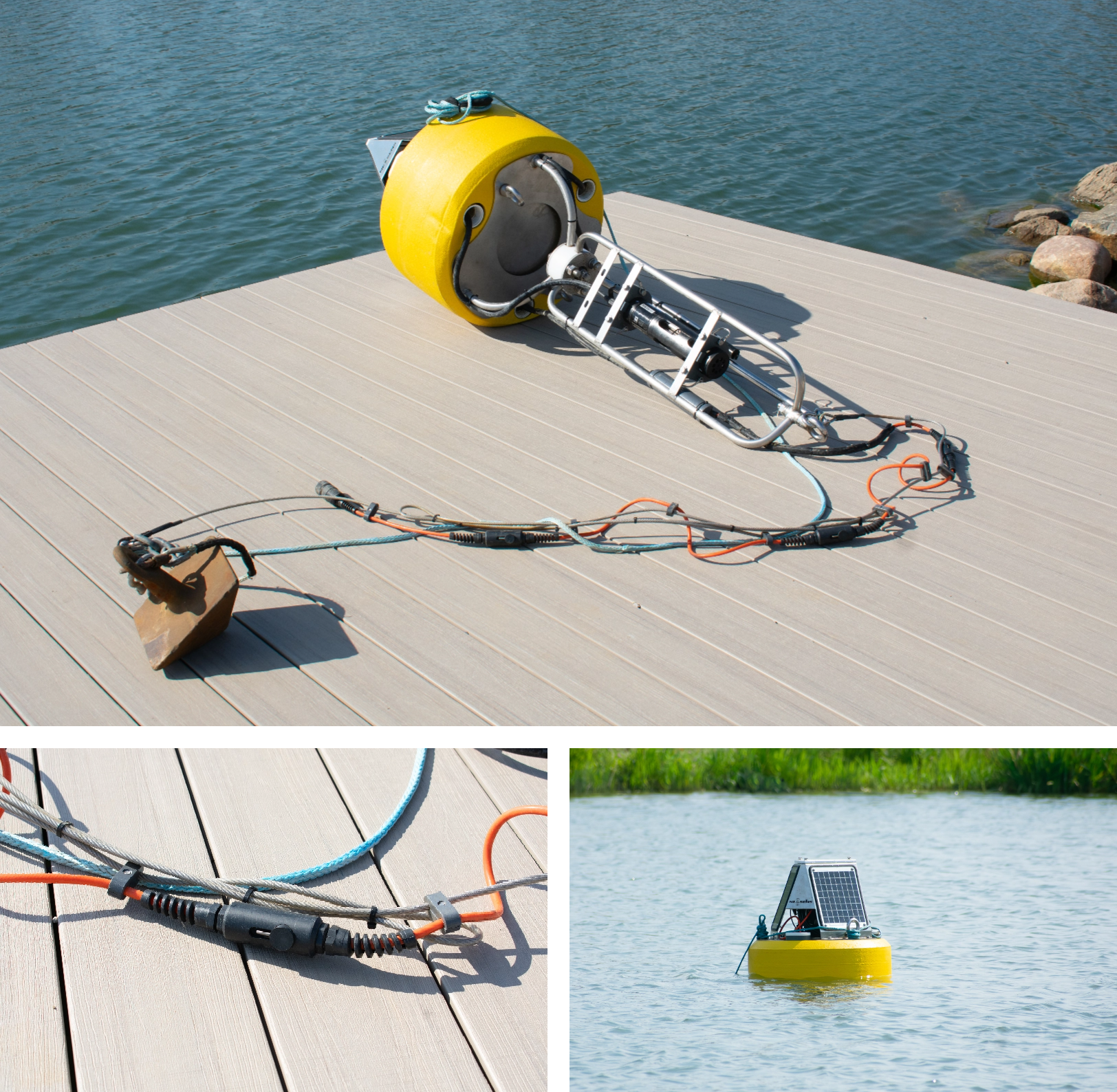
NexSens X2 Data Logger
In order to transmit data from the host of sensors at the field station, we use the NexSens X2 Data logger. The NexSens X2 Data Logger is designed to work in harsh conditions and can communicate wirelessly via cellular or satellite. It integrates with the WQData LIVE web data center, where users can view, analyze and share data in real-time.
The X2 Data Logger is compatible with a large plug-and-play sensor library, covering most environmental measurements such as temperature, pH, dissolved oxygen, turbidity, conductivity, water level, wind speed, rainfall, and more. The X2 Data Logger can be mounted on a pole, a buoy or submerged in water, depending on the application. The X2 Data Logger is the flagship product of NexSens Technology, a leading provider of environmental monitoring solutions.
The X2 Data Logger is compatible with a large plug-and-play sensor library, covering most environmental measurements such as temperature, pH, dissolved oxygen, turbidity, conductivity, water level, wind speed, rainfall, and more. The X2 Data Logger can be mounted on a pole, a buoy or submerged in water, depending on the application. The X2 Data Logger is the flagship product of NexSens Technology, a leading provider of environmental monitoring solutions.
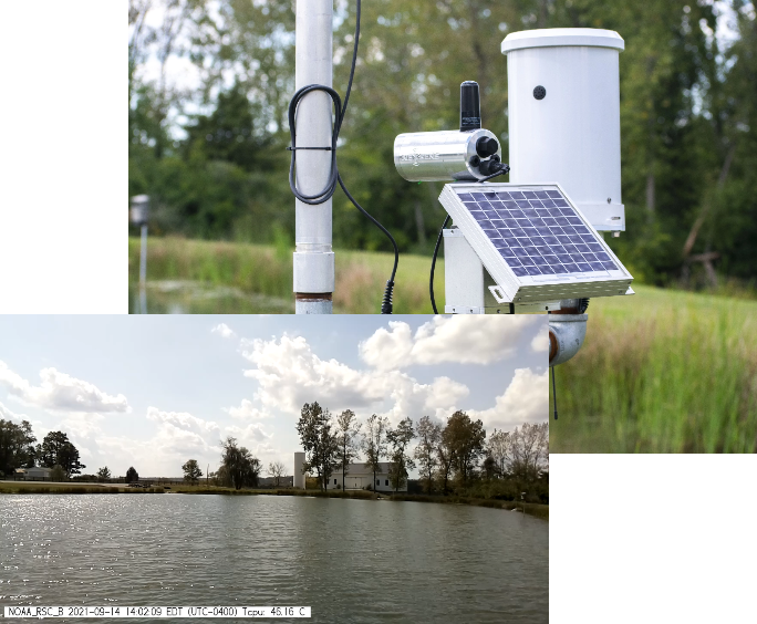
NexSens Environmental Webcam
The Environmental Webcam combines a high-resolution surveillance camera with a rugged weatherproof housing. During testing, it delivers 10-second video clips every hour of the field station pond to the WQData LIVE web datacenter. The current conditions outside are shown in detail with images up to 8MP/1080p HD video and can be seen on a phone or computer on WQData LIVE. This dependable webcam has been shown to be adaptable to deployments with environmental data loggers, weather stations, and data buoys.

PME miniDOT Logger
The PME miniDOT Logger is built to last long deployments. Environmental scientists at Fondriest Environmental performed a durability and accuracy test on miniDOT Loggers at the Fondriest Environmental Field Station. The miniDOT loggers measure dissolved oxygen (DO) and temperature, and when strung together can show stratification in a lake.
At the field station, four loggers were tied together during this short deployment in the winter. They were set to 1-minute logging intervals and secured to a rope. Each logger was secured at known depths before the units were slowly placed into the water to gather data.
Once back at the lab, data was easily plotted on the auto-generated plots for a digestible data presentation. The data indicated that the water had already turned over, so there was a clear temperature stratification and DO levels fluctuated as expected. Collectively, the units were easy to deploy and bring back to the lab for for analysis and storage. Overall, PME miniDOT Loggers are dependable for gathering the valuable data needed for today’s research.

Van Essen Diver-Link Cellular Telemetry System with Diver-Hub
At the Field Station, scientists from Fondriest Environmental wanted to monitor the groundwater levels at the station’s well. They selected a Diver-Link and TD-Diver because of the simple setup of the Diver-Link and the storage capacity and accuracy of the TD-Diver. The sensor monitors water levels daily and sends reports via the Diver-Hub Web Portal.
Near real-time monitoring at the well ensures the Fondriest Environmental Science Team can stay updated on water levels and understand how rainwater affects groundwater aquifer levels and how new urban developments slow the recharge of the aquifer. Ultimately, lower groundwater levels could impact many of the changes the Field Station has undergone in recent years, leading to damage to roads, foundations and sinkholes.
Near real-time monitoring at the well ensures the Fondriest Environmental Science Team can stay updated on water levels and understand how rainwater affects groundwater aquifer levels and how new urban developments slow the recharge of the aquifer. Ultimately, lower groundwater levels could impact many of the changes the Field Station has undergone in recent years, leading to damage to roads, foundations and sinkholes.

Onset HOBO Station and Sensors
Scientists from Fondriest Environmental wanted to learn more about soil moisture and temperature, so they selected (2) Onset HOBOnet Wireless Outdoor Temperature Sensor motes and (1) Onset HOBOnet Wireless EC-5 Soil Moisture Sensor, transmitting to an Onset RX3004-00-01 base station. These sensors collect data on soil moisture and temperature. The information collected is sent back to the RX3000 via 900 MHz wireless, facilitated by the HOBO RX3000 RXW Manager and can be viewed on a smartphone or PC.
At the farm, scientists installed the base station and sensor notes on an existing mast system using U-bolts and zip-ties. The sensor nodes, which communicate via radio to the base station, needed to be mounted within range of the station to ensure accurate data collection with no interruptions. After doing a few system verification checks (sensor connectivity and cellular connection), the RX3000 was powered up and began collecting data.
Using this real-time soil moisture system, the Fondriest Environmental Science Team can keep tabs on critical soil moisture data from afar, ensuring that crops and other vegetation are receiving ample moisture.

Sontek CastAway-CTD
Before taking the device to the field station for deployment, environmental scientists unboxed the equipment, made sure all of the components were present and reviewed the included quick start guides so that there were no surprises in the field when beginning data collection.
Transporting the CastAway to the field station for testing was relatively straightforward with all the items secured in the provided case. Tethering the CastAway to the boat was easily done and allowed the team to ensure the device was not lost. GPS connection was quick and easy, enabling immediate temperature and conductivity profiling at the lake without any delay.
Once back in the office, data from the CastAway was downloaded via the USB Bluetooth dongle to view the profiling data for the most recent cast on a computer to be assessed and shared with the science team. Getting accurate temperature, conductivity and depth profiles can be done quickly with the Sontek CastAway CTD.

YSI EXO3s Sonde
In order to test the durability and accuracy of the YSI EXO3s, environmental scientists at Fondriest performed a quality check of the sonde at the Fondriest Environmental Field Station. Getting the EXO3s together and installing the different sensors in preparation for calibration and deployment was simple. Using manual and KOR software, calibrating the various sensors was quick and easy. WQData LIVE allowed easy access to data from the EXO3s to make sure the unit was working properly and accurately. Once the sonde was back out of the water and dried off, it was easily carried back in the convenient YSI soft-sided carrying case. Overall, the YSI EXO3s has an abundance of unique features that provides a wide variety of ways to compose a multi-parameter water quality monitoring unit that can be used for any project.

NexSens G2-Rain Gauge
The NexSens G2-Rain Gauge is a durable logger that accurately measures rainfall. The sensitivity for the rain gauge is one tip per 0.01 inches of rain, thus precisely calculating total rain, rain intensity and interval rain. The G2-Rain Gauge was deployed at the field station, at Fondriest Center for Environmental Studies, to collect valuable long term data. It has been collecting precipitation data over the years to see the overall change in the local environment.
The data gathered by the G2-Rain Gauge is pushed to an online database, WQData LIVE, and can be viewed using a smartphone or PC. WQData LIVE allows for alarms and notifications to be set when a certain level is reached. For example, a rain event that produces more than 1 inch of rain within 2 hours would trigger an alarm that notifies scientists via email and text.
There is a stainless steel filter screen that prevent leaves and other debris from clogging the opening. Furthermore, the scientists added a bird guard to help reduce how frequent the instrument needs to be cleaned out. With regular maintenance, the G2-Rain Gauge has collected accurate long term data for several years.
NexSens TS210 Sensors
The NexSens TS210 Thermistor String is a device that measures temperature profiles in lakes, streams and coastal waters. The Fondriest Environmental Field Station uses the NexSens TS210 Thermistor String to collect temperature data throughout the Spring, Summer and Fall. The data is transmitted to the NexSens WQData LIVE web data center, where it can be viewed online via the Field Stations Public Portal website .
The NexSens TS210 is a reliable underwater temperature sensor that features an integral titanium thermistor. The thermistor is secured and epoxied in a protective housing, making it ideal for underwater deployments. The sensor is accurate to +/- 0.075 degrees Celsius, and the data is transmitted via RS-485 Modbus RTU string bus for integration with data loggers and SCADA/PLC systems. The nominal sensor drift at 50,000 hours is 0.003118 degrees Celsius, which means that no calibration is necessary.
The NexSens TS210 is a reliable underwater temperature sensor that features an integral titanium thermistor. The thermistor is secured and epoxied in a protective housing, making it ideal for underwater deployments. The sensor is accurate to +/- 0.075 degrees Celsius, and the data is transmitted via RS-485 Modbus RTU string bus for integration with data loggers and SCADA/PLC systems. The nominal sensor drift at 50,000 hours is 0.003118 degrees Celsius, which means that no calibration is necessary.
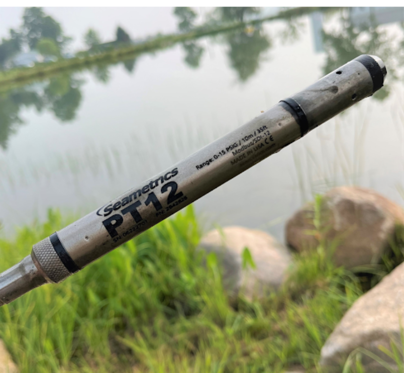
Seametrics PT12 Sensor
The Seametrics PT12 Sensor is made to withstand rugged long-term deployments with its 316 stainless steel or titanium housings options. The size of the sensor also allows it to fit into limited spaces like a well or places with a small opening. Scientists at Fondriest Environmental have integrated a Seametrics PT12 sensor to a pole mount NexSens X2 Data Logger system. The sensor collects accurate temperature and pressure measurements. With those measurements, the X2 data logger has the ability to calculate the water level as another parameter.
Once the Seametrics PT12 sensor was integrated with the data logger, it was quickly ready to deploy in the field. The sensor easily connected to the logger through one of the water-tight ports and was powered on by a solar panel through the logger. The sensor passes along the essential data to the data logger, which in turns sends the information to an online database (WQData LIVE).
The water level, pressure and temperature of the pond can be viewed 24/7 through the field station WQData LIVE public portal. With some WQData alarms set into place, a notification will be sent when the water reaches a certain level. The notifications are a peace of mind to be able to assess the data and react quickly to the area for potential flooding.
WEATHER STATION COMPARISON PROJECT
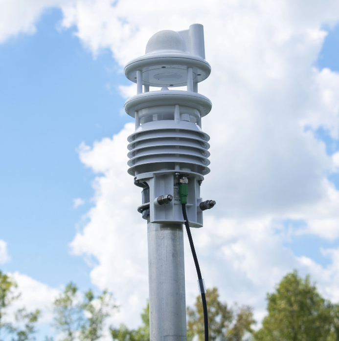
Lufft WS800 Weather Station
Environmental scientists at Fondriest Environmental have conducted multiple seasonal deployments of the WS800 weather station for insight into conditions at the Fondriest Environmental Field Station. The WS800 is mounted with other rain gauges and weather stations to compare data. Comparisons of the different methods for precipitation monitoring have been of keen interest to researchers and governmental bodies. Using a NexSens X2 Environmental Data Logger and NexSens Lufft Mount, the station is easy to configure and deploy. Lufft station data is transmitted to WQData LIVE, and comparisons are made between a NexSens tipping bucket rain gauge and the radar precipitation sensor on the device.
Read More... Products | Rental | News | Learning
Center | Field
Station | Company
© 2024 Fondriest Environmental, Inc. | Questions? Call 888.426.2151 or email customercare@fondriest.com
