
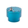
Geolux Non-Contact Flow Sensors
Features
- Contactless water level and surface velocity measurement
- Integrated discharge (flow) calculation
- RS-232, RS-485 Modbus, SDI-12, analog 4-20 mA interfaces in all models
- Free ground shipping
- Expedited repair and warranty service
- Lifetime technical support
- More
Oerview
The Geolux Non-Contact Flow Sensor has an integrated radar surface velocity and level sensor for contactless velocity, level, and discharge (flow) measurements.
Mechanics
Contactless radar technology enables quick and simple sensor installation above the water surface with minimum maintenance. Calculation of the total flow discharge is internally implemented within the instrument by combining surface velocity measurement, water level measurement, and a configured cross-section of the river or channel. Defining the measurement parameters such as profile cross-section, material of the edges, location of the sensor above the water, and all other instrument settings can be easily set with the Geolux configuration application using any available communication interface.
General Specifications
Detection Distance: 15m / 30m / 50m
Speed Range: 0.02m/s to 15m/s
Speed Resolution: 0.001m/s
Speed Accuracy: 1%
Level Resolution: 0.5mm
Level Accuracy: +/-2mm
IP Rating: IP68
Electrical & Mechanical
Input Voltage: 9 to 27 VDC
Power Consumption: 1,3 W operational; 0,235 W standby
Maximal Current: < 750 mA
Temperature Range: -40 °C to +85 °C (without heating or coolers)
Enclosure Dimensions: 150mm x 200mm x 250mm
Weight: 3.08kg
Interface
Serial Interface: 1 x serial RS-485 half-duplex; 1 x serial RS-232 (two wire interface)
Baud Rate: 9600 bps to 115200 bps
Serial Protocols: Modbus, GLX-NMEA
Other Protocols: SDI-12
Analog Output: 4-20 mA, programmable velocity, level or flow
Certificates
EN 61326-1:2013
ETSI EN 301 489-1
ETSI EN 301 489-3
EN 301 489-3 V2.1.1:2019
EN 301 489-1 V2.2.3:2019
EN 300 440 V2.2.1:2018
EN 62368-1:2014+A11:2007;
EN 60950-22:2017
EN 61010-1:2010
FCC Part 15 class B
ISED RSS211
Select Options


In The News

Data-Driven Advocacy on the Lower Deschutes River
Like many freshwater environments, the Deschutes River in Oregon is under pressure from development, pollution, and climate change. Many rivers, streams and lakes in the Deschutes Basin do not meet Oregon water quality standards –where state water quality monitoring assesses levels of bacteria, pH, dissolved oxygen, temperature, and fine sediment. Hannah Camel is the Water Quality Coordinator for the Deschutes River Alliance (DRA), a non-profit organization that focuses on the health of the lower 100 miles of the Deschutes River–the area most affected by human intervention. As a data-driven organization, the DRA has benefited from the installation of two NexSens X2 data loggers.
Read More
Expanding the Port Everglades: Real-Time Monitoring of Water Quality Conditions from Planned Dredging Operation
The Port Everglades in Broward County, Florida, serves large trade vessels and cruiseliners and incoming and outgoing recreational boaters. However, as cargo ships become larger, the port must expand. A dredging project led by the US Army Corps of Engineers will substantially deepen and widen the port's navigation channel to accommodate larger Panamax cargo ships and modern cruise liners. As a result of this project, a large amount of sediment will be displaced into the water column. This suspended sediment may settle outside of the project area, burying benthic organisms like corals, and possibly carrying harmful particulates to other regions. [caption id="attachment_39497" align="aligncenter" width="2560"] A CB-950 and CB-25 deployed on site at Port Everglades.
Read More
It’s Time to React to Water Quality: Proteus Multiparameter Probe aboard NexSens Buoy
Water quality monitoring is essential for safeguarding public health, protecting ecosystems, and ensuring the sustainability of water resources. Contaminants such as industrial pollutants, agricultural runoff, and sewage discharge can severely impact aquatic life and pose serious risks to human health if left unchecked. Traditionally, water quality monitoring has been a slow and labor-intensive process, requiring samples to be collected, transported to a lab, and analyzed—a process that can take days. However, with the advancement of real-time sensor technology, environmental agencies, researchers, and industries can now monitor water quality instantly.
Read More