
Geolux Non-Contact Level Sensors
Features
- Contactless water level measurement
- RS-232, RS-485 Modbus, SDI-12, analog 4-20 mA interfaces in all models
- Robust, small-size IP68 enclosure
- Free ground shipping
- Expedited repair and warranty service
- Lifetime technical support
- More
Overview
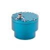
The Geolux LX-80 series of instruments are advanced contactless radar level meters designed for precise distance measurement from the instrument to the water surface for water level and flood monitoring applications.
Mechanics
This functionality is achieved by transmitting an electromagnetic wave in 80 GHz frequency range (W band), and measuring the frequency shift of the electromagnetic wave reflected from the water surface. Instruments are characterised by low power consumption, supported by multiple communication interfaces, compatible with third-party dataloggers, and support remote configuration of all instrument settings over any available digital communication interface. Narrow beam width of only 5° allows for simpler installation, and that nearby structures such as bridge railings or pillars do not interfere with the accuracy of the water level measurement.
General Specifications
Radar Type: W-band 77-81 GHz FMCW radar
Beam Angle: 5°
Detection Distance: 8m / 15m / 30m / 50m
Resolution: 0.5mm
Accuracy: +/- 2mm
Sampling Frequency: 1 sample per second
IP Rating: IP68
Electrical & Mechanical
Connector: M12 circular 12 -pin
Input Voltage: 9 to 27 VDC
Power Consumption: 0.36 W; standby 0.15 W; sleep 0.03 W; extended 0.6 W
Max Current: < 470 mA
Temperature Range: -40 °C to +85 °C (without heating or coolers)
Enclosure Dimensions: Φ 65mm x H 78mm
Interface
Serial Interface: 1 x serial RS-485 half-duplex; 1 x serial RS-232 (two wire interface)
Serial Baud Rate: 9600 bps to 115200 bps
Serial Protocols: Modbus, GLX-NMEA
Analog Interface: 4-20 mA
Other Interfaces: SDI-12
Certificates
EN 61326-1:2013
ETSI EN 301 489-1
ETSI EN 301 489-3
EN 62368-1:2014+A11:2007;
EN 60950-22:2017
EN 61010-1:2010
FCC Part 15 class B
ISED RSS211
Select Options


In The News

Monitoring Mariculture in the Gulf of Alaska
The mariculture industry in the Gulf of Alaska has been steadily growing in recent years, guided by ongoing research to help refine farm location and cultivation practices. A subset of aquaculture, mariculture focuses on rearing organisms in the open ocean. In Alaska, finfish farming is illegal, so most farms cultivate kelp, oysters, or a combination of the two. These small, locally operated farms started popping up in the Gulf of Alaska in the early 1990s, when shellfish farming first became legal. Kelp farming did not begin to catch on in the state until 2016. Many of the coastal areas that have grown interested in mariculture are historically commercial fishing communities.
Read More
Supplying Seattle’s Drinking Water: Using Data Buoys to Monitor the Cedar River Municipal Watershed
Providing clean, safe, and reliable drinking water for the 1.6 million people in the greater Seattle area is a top priority for Seattle Public Utilities (SPU). With limited water supplies, SPU dedicates considerable resources to maintain its watersheds and mountain reservoirs. About 70 percent of Seattle Water comes from the Cedar River Municipal Watershed , and the other 30 percent comes from the South Fork Tolt River Watershed . [caption id="attachment_39574" align="alignnone" width="940"] Data buoy in Chester Morse Lake . (Credit: Kevin Johnson / Seattle Public Utilities) [/caption] Jamie Thompson, a fisheries biologist at SPU, monitors aquatic ecosystems centered on fish listed under the U.S. Endangered Species Act (ESA).
Read More
Data-Driven Advocacy on the Lower Deschutes River
Like many freshwater environments, the Deschutes River in Oregon is under pressure from development, pollution, and climate change. Many rivers, streams and lakes in the Deschutes Basin do not meet Oregon water quality standards –where state water quality monitoring assesses levels of bacteria, pH, dissolved oxygen, temperature, and fine sediment. Hannah Camel is the Water Quality Coordinator for the Deschutes River Alliance (DRA), a non-profit organization that focuses on the health of the lower 100 miles of the Deschutes River–the area most affected by human intervention. As a data-driven organization, the DRA has benefited from the installation of two NexSens X2 data loggers.
Read More