
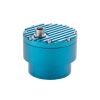
Geolux Non-Contact Snow Depth Sensor
Features
- Accuracy is not affected by air density, temperature, or wind
- Small and robust device, easy to install and maintain
- Extremely narrow radar beam width of only 5° (+/- 2.5°)
- Free ground shipping
- Expedited repair and warranty service
- Lifetime technical support
- More
Overview
The Geolux LX80-S is an innovative snow depth sensor that uses advanced radar technology to accurately measure the distance from the sensor down to the surface of the snow.
Radar Technology
Unlike traditional ultrasound devices that require temperature compensation due to their distance measurement being affected by air density, the LX80-S radar is not impacted by such environmental changes. Moreover, ultrasonic sensors are more susceptible to negative effects from snowfall or icicles, which can form close to the device. The LX80-S radar uses advanced signal processing algorithms for precipitation detection, and has a narrow radar beam of only 5°, which prevents such issues.
Installation
Installing and maintaining the LX80-S is easy, and the device can cover a long detection distance of up to 15 meters. The radar technology allows for non-invasive measurement from above the snow, ensuring that the snow’s structure is not disturbed in any way.
Applications
The LX80-S has many applications, including continuous monitoring of snowpack buildup and melting, making it essential for meteorological monitoring, hydrological planning, avalanche warning, and ski resorts. The device provides accurate data on snow depth, which is crucial for many industries, especially those that depend on snow conditions.
General Specifications
Radar Type: W-band 77-81 GHz FMCW radar
Beam Angle: 5°
Detection Distance: 15m
Blanking Distance: 0.4m
Resolution: 0.5mm
Accuracy: +/- 1mm
Sampling Frequency: 10 samples per second
IP Rating: IP68
Electrical & Mechanical
Connector: M12 circular 12 -pin
Input Voltage: 9 to 27 VDC
Power Consumption: operating 1.5 W; standby 0.15 W; sleep 0.03 W; extended 0.6 W
Max Current: < 470 mA
Temperature Range: -40 °C to +85 °C (without heating or coolers)
Enclosure Dimensions: Φ 65mm x H 78mm
Interface
Serial Interface: 1 x serial RS-485 half-duplex; 1 x serial RS-232 (two wire interface)
Serial Baud Rate: 9600 bps to 115200 bps
Serial Protocols: Modbus, GLX-NMEA
Analog Interface: 4-20 mA
Other Interfaces: SDI-12
Certificates
EN 61326-1:2013
ETSI EN 301 489-1
ETSI EN 301 489-3
EN 62368-1:2014+A11:2007;
EN 60950-22:2017
EN 61010-1:2010
FCC Part 15 class B
ISED RSS211
Select Options


In The News

Data-Driven Advocacy on the Lower Deschutes River
Like many freshwater environments, the Deschutes River in Oregon is under pressure from development, pollution, and climate change. Many rivers, streams and lakes in the Deschutes Basin do not meet Oregon water quality standards –where state water quality monitoring assesses levels of bacteria, pH, dissolved oxygen, temperature, and fine sediment. Hannah Camel is the Water Quality Coordinator for the Deschutes River Alliance (DRA), a non-profit organization that focuses on the health of the lower 100 miles of the Deschutes River–the area most affected by human intervention. As a data-driven organization, the DRA has benefited from the installation of two NexSens X2 data loggers.
Read More
Expanding the Port Everglades: Real-Time Monitoring of Water Quality Conditions from Planned Dredging Operation
The Port Everglades in Broward County, Florida, serves large trade vessels and cruiseliners and incoming and outgoing recreational boaters. However, as cargo ships become larger, the port must expand. A dredging project led by the US Army Corps of Engineers will substantially deepen and widen the port's navigation channel to accommodate larger Panamax cargo ships and modern cruise liners. As a result of this project, a large amount of sediment will be displaced into the water column. This suspended sediment may settle outside of the project area, burying benthic organisms like corals, and possibly carrying harmful particulates to other regions. [caption id="attachment_39497" align="aligncenter" width="2560"] A CB-950 and CB-25 deployed on site at Port Everglades.
Read More
It’s Time to React to Water Quality: Proteus Multiparameter Probe aboard NexSens Buoy
Water quality monitoring is essential for safeguarding public health, protecting ecosystems, and ensuring the sustainability of water resources. Contaminants such as industrial pollutants, agricultural runoff, and sewage discharge can severely impact aquatic life and pose serious risks to human health if left unchecked. Traditionally, water quality monitoring has been a slow and labor-intensive process, requiring samples to be collected, transported to a lab, and analyzed—a process that can take days. However, with the advancement of real-time sensor technology, environmental agencies, researchers, and industries can now monitor water quality instantly.
Read More