
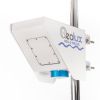
Geolux Non-Contact Surface Velocity Sensor
Features
- Contactless surface velocity measurement
- RS-232, RS-485 Modbus, analog 4-20 mA interfaces in all models
- Robust, small-size IP68 enclosure
- Free ground shipping
- Expedited repair and warranty service
- Lifetime technical support
- More
Overview
The Geolux Non-Contact Surface Velocity Sensor uses radar technology for providing contactless measurement of velocity for water level, flood, and discharge monitoring applications.
Mechanics
Contactless radar technology enables quick and simple sensor installation above the water surface with minimum maintenance. The radar operates in K-band (24.075 GHz to 24.175 GHz) and provides velocity readings 10 times per second over serial RS-232, RS-485 Modbus, and analog 4-20 mA output. The instrument is easily integrated with third-party dataloggers and all of the settings can be remotely configured. An integrated MEMS sensor is used for automatic angle compensation. Internal vibration monitoring and SNR calculation can be used for measurement quality assessment.
General Specifications
Radar Type: K-band 24.075 GHz to 24.175 GHz Doppler radar, 20 dBm EIRP
Beam Angle: 12° Azimuth; 24° Elevation
Detection Distance: Up to 20m above the water
Speed Range: 0.02m/s to 15m/s
Resolution: 0.001m/s
Accuracy: 1%
Sampling Frequency: 10 samples per second
IP Rating: IP68
Electrical & Mechanical
Input Voltage: 9 to 27 VDC
Power Consumption: 950 mW operational, 85 mW standby
Max Current: < 250 mA
Temperature Range: -40 °C to +85 °C (without heating or coolers)
Device Outer Dimensions: 110mm x 90mm x 50mm
Interface
Serial Interface: 1 x serial RS-485 half-duplex; 1 x serial RS-232 (two wire interface)
Serial Baud Rate: 9600 bps to 115200 bps
Serial Protocols: GLX-NMEA, Modbus
Analog Output: 1 x 4-20 mA
Connector: M12 circular 12-pin
Certificates
EN 60950-1:2006+A1:2010+A11:2009+A12:2011+A2:2013
EN 62311:2008
EN 301 489-3 V2.1.1:2019
EN 301 489-1 V2.2.3:2019
EN 61000-6-2:2019
EN 61000-6-3:2021
EN 6100-6-2:2017
EN 300 440 V2.2.1:2018
EN 62368-1:2014+A11:2017
EN 62311:2008
EN 60529:2000+A1:2008+A2:2014 IP68
FCC Part 15 class B
ISED RSS210
Select Options


In The News

Three Decades of Research at Acton Lake
A multi-disciplinary team at Miami University, Ohio, has been studying the environmental change at Acton Lake for over three decades. Using three different NexSens buoys over this time, the team has an incredible archive of data that is helping build a picture of Acton’s past, present, and future. Until recently, a NexSens CB-50 buoy was used alongside other environmental monitoring at Acton Lake. In May 2025, the Miami team deployed a new XB-200 buoy , future-proofing their ongoing monitoring using real-time buoy systems. Acton Lake, a small hypereutrophic reservoir in southwest Ohio, covers 2.4km² and has a maximum depth of about 8m. The dam was built in 1956, and the lake has a large agricultural watershed.
Read More
Source Water Monitoring in Albany, New York: Tracing Water Quality throughout Tributaries
Thousands of US cities pull their drinking water from natural source waters like reservoirs, rivers, and streams, making overall watershed health a key consideration for water providers. In Albany, New York, the Albany Department of Water and Water Supply delivers drinking water to over 100,000 residents as well as monitors and manages the larger drinking water supply watershed. Hannah Doherty, Environmental Specialist at the Albany Department of Water and Water Supply , spends her days working with a small team to monitor the drinking supply and the connected water bodies. Doherty explains, “We’re the first to encounter the water that ends up being the drinking water.
Read More
Wildfire Prevention in the Sierra Nevada Region with the Yuba Watershed Institute
Though recent wildfires have sparked new conversations about wildfire management and response, groups like the Yuba Watershed Institute have been monitoring the forests and water resources of the Sierra Nevada region for decades, managing approximately 5,000 acres of land with the Bureau of Land Management (BLM) and about 7,000 acres in private land partnerships. The goal of the Institute is to work with local communities and land agencies to improve watershed and forestry management through informed practices and public outreach. The goals of the Yuba Watershed Institute are three-fold: Improve the ability of fire suppression agencies like the California Department of Forestry and Fire Protection ( CAL FIRE ) and the US Forest Service.
Read More