
Geolux Non-Contact Wave Sensors
Features
- Measurement of water level and automatic calculation of wave parameters
- Fast sampling rate of 10 samples per second for accurate wave analysis
- Easy installation up to 15m or 30m above the water surface
- Expedited repair and warranty service
- Lifetime technical support
- More
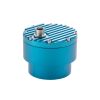
The Geolux non-contact wave sensor is a high sampling frequency version of the radar level sensor, which is targeted towards tidal monitoring, oceanographic, coastal and maritime applications. The level sensor uses radar technology to accurately measure the distance between the radar instrument and the surface of the water. The water level measurements are repeatedly performed 10 times per second. An internal wave analysis module uses these water level measurements for advanced wave analysis.
Wave parameters, such as significant wave height, zero up-crossing period, crest period as well as minimum, maximum, mean and median water level are automatically calculated by the radar unit. The instrument can internally store up to 20 minutes of water level data to be used for calculation of the wave parameters. The low power consumption of the instrument, the integrated wave analysis module, small form factor and a rugged enclosure make this instrument easy to setup and use.
General Specifications
Radar Type: W-band 77-81 GHz FMCW radar
Beam Angle: 5°
Detection Distance: 15m / 30m
Resolution: 0.5mm
Accuracy: +/- 2 mm
Sampling Frequency: 10 samples per second
IP Rating: IP68
Electrical & Mechanical
Connector: M12 circular 12 -pin
Input Voltage: 9 to 27 VDC
Power Consumption: 0.36 W; standby 0.15 W; sleep 0.03 W; extended 0.6 W
Max Current: < 470 mA
Temperature Range: -40 °C to +85 °C (without heating or coolers)
Enclosure Dimensions: Φ 65mm x H 78mm
Interface
Serial Interface: 1 x serial RS-485 half-duplex; 1 x serial RS-232 (two wire interface)
Serial Baud Rate: 9600 bps to 115200 bps
Serial Protocols: Modbus, GLX-NMEA
Analog Interface: 4-20 mA
Other Interfaces: SDI-12
Certificates
EN 61326-1:2013
ETSI EN 301 489-1
ETSI EN 301 489-3
EN 62368-1:2014+A11:2007;
EN 60950-22:2017
EN 61010-1:2010
FCC Part 15 class B
ISED RSS211
Select Options


In The News
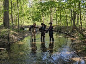
Lake Erie Volunteer Science Network: Building Trust in Citizen Science Programs
Citizen science programs have popped up across the United States, focusing on connecting local communities with nearby water resources and building a trustworthy data pool over the sampling period. While commonly utilized as a means of ensuring that large watersheds or lake regions are adequately sampled, the credibility and success of such programs have been called into question. [caption id="attachment_38996" align="alignnone" width="940"] HRWC volunteers measure stream velocity across a subsection of Woods Creek, a tributary of the Huron River near Belleville, Michigan. Stream velocity measurements can be combined with water level measurements to calculate stream flow and chemical parameter loads.
Read More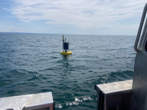
Monitoring Lake Erie’s Eastern Basin: Building Long-Term Data and Real-Time Public Solutions
In the eastern basin of Lake Erie, off the coast of Dunkirk, New York, a data buoy collects valuable water quality, weather, and wave data that inform residents and regulatory groups of conditions on the water. Since 2011, Buffalo State University’s Great Lakes Center has maintained and operated the Dunkirk buoy with funding from the Great Lakes Observing System (GLOS) and field support from the NYSDEC Lake Erie Fisheries Research Unit. [caption id="attachment_38976" align="aligncenter" width="940"] The Dunkirk Buoy viewed from the research vessel after being deployed in early spring.
Read More
SonTek CastAway-CTD Meter Review
Lightweight and easy to use, the SonTek CastAway offers a convenient 3-in-1 solution for measuring conductivity, temperature, and depth profiles. At a 5 Hz sampling rate, the CastAway is designed for up to 1 m/s free-fall through the water column. With fast response and accurate conductivity, temperature, and depth measurements, the CastAway is ideal for thermocline and halocline profiling. The unit also reports salinity and speed of sound. [caption id="attachment_38732" align="alignnone" width="940"] Environmental scientist, Katelyn Kubasky, holding the SonTek CastAway in front of the pond at the Fondriest Center for Environmental Studies.
Read More