
Geolux Non-Contact Wave & Tide Sensors
Features
- Measurement of water level and automatic calculation of wave parameters
- Fast sampling rate of 10 samples per second for accurate wave analysis
- Easy installation up to 15m, 30m or 50m above the water surface
- Free ground shipping
- Expedited repair and warranty service
- Lifetime technical support
- More
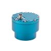
The Geolux non-contact wave sensor is a high sampling frequency version of the radar level sensor, which is targeted towards tidal monitoring, oceanographic, coastal and maritime applications. The level sensor uses radar technology to accurately measure the distance between the radar instrument and the surface of the water. The water level measurements are repeatedly performed 10 times per second. An internal wave analysis module uses these water level measurements for advanced wave analysis.
Wave parameters, such as significant wave height, zero up-crossing period, crest period as well as minimum, maximum, mean and median water level are automatically calculated by the radar unit. The instrument can internally store up to 20 minutes of water level data to be used for calculation of the wave parameters. The low power consumption of the instrument, the integrated wave analysis module, small form factor and a rugged enclosure make this instrument easy to setup and use.
General Specifications
Radar Type: W-band 77-81 GHz FMCW radar
Beam Angle: 5°
Detection Distance: 15m / 30m / 50m
Resolution: 0.5mm
Accuracy: +/- 2 mm
Sampling Frequency: 10 samples per second
IP Rating: IP68
Electrical & Mechanical
Connector: M12 circular 12 -pin
Input Voltage: 9 to 27 VDC
Power Consumption: 0.36 W; standby 0.15 W; sleep 0.03 W; extended 0.6 W
Max Current: < 470 mA
Temperature Range: -40 °C to +85 °C (without heating or coolers)
Enclosure Dimensions: Φ 65mm x H 78mm
Interface
Serial Interface: 1 x serial RS-485 half-duplex; 1 x serial RS-232 (two wire interface)
Serial Baud Rate: 9600 bps to 115200 bps
Serial Protocols: Modbus, GLX-NMEA
Analog Interface: 4-20 mA
Other Interfaces: SDI-12
Certificates
EN 61326-1:2013
ETSI EN 301 489-1
ETSI EN 301 489-3
EN 62368-1:2014+A11:2007;
EN 60950-22:2017
EN 61010-1:2010
FCC Part 15 class B
ISED RSS211
Select Options


In The News

Supplying Seattle’s Drinking Water: Using Data Buoys to Monitor the Cedar River Municipal Watershed
Providing clean, safe, and reliable drinking water for the 1.6 million people in the greater Seattle area is a top priority for Seattle Public Utilities (SPU). With limited water supplies, SPU dedicates considerable resources to maintain its watersheds and mountain reservoirs. About 70 percent of Seattle Water comes from the Cedar River Municipal Watershed , and the other 30 percent comes from the South Fork Tolt River Watershed . [caption id="attachment_39574" align="alignnone" width="940"] Data buoy in Chester Morse Lake. Data buoy in Masonry Pool. (Credit: Kevin Johnson / Seattle Public Utilities) [/caption] Jamie Thompson, a fisheries biologist at SPU, monitors aquatic ecosystems centered on fish listed under the U.S. Endangered Species Act (ESA).
Read More
Data-Driven Advocacy on the Lower Deschutes River
Like many freshwater environments, the Deschutes River in Oregon is under pressure from development, pollution, and climate change. Many rivers, streams and lakes in the Deschutes Basin do not meet Oregon water quality standards –where state water quality monitoring assesses levels of bacteria, pH, dissolved oxygen, temperature, and fine sediment. Hannah Camel is the Water Quality Coordinator for the Deschutes River Alliance (DRA), a non-profit organization that focuses on the health of the lower 100 miles of the Deschutes River–the area most affected by human intervention. As a data-driven organization, the DRA has benefited from the installation of two NexSens X2 data loggers.
Read More
Expanding the Port Everglades: Real-Time Monitoring of Water Quality Conditions from Planned Dredging Operation
The Port Everglades in Broward County, Florida, serves large trade vessels and cruiseliners and incoming and outgoing recreational boaters. However, as cargo ships become larger, the port must expand. A dredging project led by the US Army Corps of Engineers will substantially deepen and widen the port's navigation channel to accommodate larger Panamax cargo ships and modern cruise liners. As a result of this project, a large amount of sediment will be displaced into the water column. This suspended sediment may settle outside of the project area, burying benthic organisms like corals, and possibly carrying harmful particulates to other regions. [caption id="attachment_39497" align="aligncenter" width="2560"] A CB-950 and CB-25 deployed on site at Port Everglades.
Read More