
Geotech Oil/Water Interface Probes With Float
Features
- Audible & visible alarms activated on reel when probe contacts product & water
- Highly accurate Tefzel coated steel tape marked in engineering or metric increments
- Extremely durable polypropylene storage reel with rugged aluminum frame
- Free ground shipping
- Expedited repair and warranty service
- Lifetime technical support
- More
Overview
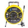
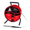
The Geotech Interface Probe With Float is a portable reel-mounted instrument that provides measurements of liquids lighter and heavier than water. When the Interface Probe is lowered down a well and contacts the product layer, a solid tone and red light alarm is activated at the reel. When the probe detects water, the tone begins to oscillate and the light changes to green.
Mechanics
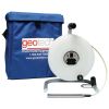
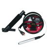
The durable storage reel is made from polypropylene with a rugged aluminum frame. The probe consists of a stainless steel and FEP probe attached to a reel-mounted, Tefzel-coated engineer's tape. The engineer's tape comes in engineering or metric increments and is accurate to 1/100 of a foot. The probe has a float that detects hydrocarbon levels and a pair of stainless steel contacts for sensing conductive fluids. The Interface Probe includes a padded carrying case and tape guide.
- (1) Interface probe with float
- (1) Carrying case
- (1) Tape guide
- (1) Operations manual
Select Options


In The News

Research in the Reserve: Promoting Interdisciplinary Conservation at the Great Bay National Estuarine Research Reserve
On an early winter day in 1973, a helicopter buzzed over Durham, New Hampshire, just a few miles from the Atlantic Ocean. One of the helicopter’s guests, oil magnate Aristotle Onassis, owner of Olympic Refining, looked east of town and saw what he hoped would become the world’s largest oil refinery. Instead, he saw the Great Bay; thousands of acres of green coastal forest, mud flats, salt marshes, and estuarine tidal waters stretching over the land toward New Hampshire's small Eastern coastline. Onassis likely also saw a group of Durham residents staked out on the bay’s coast, ready for him to pass overhead. While out of place in the natural setting, an obvious message was spelled out in red paper: “Not Here.
Read More
Floating Global New Ideas: Buoy-Enabled Research at Florida Agricultural and Mechanical University’s School of the Environment
Florida Agricultural and Mechanical University (FAMU), based in Tallahassee, Florida, is the highest-rated public Historically Black College or University in the United States. FAMU’s School of the Environment (FAMU-SOE) offers BS and BA degrees in Environmental Studies, and BS, MS, and Ph.D. degrees in Environmental Science, with specialisms available in areas including Environmental Policy and Risk Management, Aquatic and Terrestrial Ecology, and Biomolecular Sciences. In 2021, FAMU-SOE deployed a NexSens CB-450 buoy in Apalachee Bay, a key oyster farming area around 30 miles south of Tallahassee. The buoy has quickly been incorporated into the curriculum, providing environmental insights for student research, the community, and beyond. Dr.
Read More
Monitoring Habitat Suitability and Water Quality in Northwest Arkansas Springs
Northwest Arkansas has seen an economic, industrial, and population boom in recent years as a result of expanding businesses, which have created thousands of jobs in the region and the mass migration of employees and construction companies. However, with this growth has come rapid urbanization and the degradation of the natural landscape, specifically the freshwater springs that can be found throughout the region. These springs are critical habitat centers for native wildlife, home to threatened and endangered fish, and those that have yet to be listed. Zach Moran, Assistant Professor of Fisheries Science at Arkansas Technical University, is working to help monitor these habitats and provide key data that will hopefully inform future development in the region.
Read More