
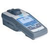
Geotech Portable Turbidity Meter
The Geotech Portable Turbidity Meter is designed to withstand the rigor of field analysis with laboratory precision and repeatability.
Features
- White light source meets EPA Method 180.1
- Shockproof, waterproof, and floats in water - even with the lid open
- Integrated data logger stores up to 1000 data sets
- Free ground shipping
- Expedited repair and warranty service
- Lifetime technical support
- More
Overview
The Geotech Portable Turbidity Meter is an extremely robust portable/laboratory instrument. Data points from field sample events can be stored in memory and transferred to a computer or other storage devices. Provides fluid clarity insight by shining light onto a sample and measuring the amount of light scattered by suspended particles in the fluid.
Included in Kit
- Turbidity Meter
- Economy Case with Custom Cut Foam (pictured above)
- 4 Primary Calibration Standards: 0.10, 20, 100, 800 NTU
- Lint-Free Cloth
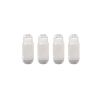
- 2 Sample Vials
- 4 AA Batteries
- (1) Turbidity meter
- (1) Case with custom cut foam
- (4) Primary calibration standards: 0.10, 20, 100, 800 NTU
- (1) Lint-free cloth
- (2) Sample vials
- (4) AA batteries
Select Options


In The News

Supplying Seattle’s Drinking Water: Using Data Buoys to Monitor the Cedar River Municipal Watershed
Providing clean, safe, and reliable drinking water for the 1.6 million people in the greater Seattle area is a top priority for Seattle Public Utilities (SPU). With limited water supplies, SPU dedicates considerable resources to maintain its watersheds and mountain reservoirs. About 70 percent of Seattle Water comes from the Cedar River Municipal Watershed , and the other 30 percent comes from the South Fork Tolt River Watershed . [caption id="attachment_39574" align="alignnone" width="940"] Data buoy in Chester Morse Lake . (Credit: Kevin Johnson / Seattle Public Utilities) [/caption] Jamie Thompson, a fisheries biologist at SPU, monitors aquatic ecosystems centered on fish listed under the U.S. Endangered Species Act (ESA).
Read More
Data-Driven Advocacy on the Lower Deschutes River
Like many freshwater environments, the Deschutes River in Oregon is under pressure from development, pollution, and climate change. Many rivers, streams and lakes in the Deschutes Basin do not meet Oregon water quality standards –where state water quality monitoring assesses levels of bacteria, pH, dissolved oxygen, temperature, and fine sediment. Hannah Camel is the Water Quality Coordinator for the Deschutes River Alliance (DRA), a non-profit organization that focuses on the health of the lower 100 miles of the Deschutes River–the area most affected by human intervention. As a data-driven organization, the DRA has benefited from the installation of two NexSens X2 data loggers.
Read More
Expanding the Port Everglades: Real-Time Monitoring of Water Quality Conditions from Planned Dredging Operation
The Port Everglades in Broward County, Florida, serves large trade vessels and cruiseliners and incoming and outgoing recreational boaters. However, as cargo ships become larger, the port must expand. A dredging project led by the US Army Corps of Engineers will substantially deepen and widen the port's navigation channel to accommodate larger Panamax cargo ships and modern cruise liners. As a result of this project, a large amount of sediment will be displaced into the water column. This suspended sediment may settle outside of the project area, burying benthic organisms like corals, and possibly carrying harmful particulates to other regions. [caption id="attachment_39497" align="aligncenter" width="2560"] A CB-950 and CB-25 deployed on site at Port Everglades.
Read More