
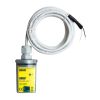
Global Water RG200 Tipping Bucket Rain Gauge
The Global Water RG200 Rain Gauge is a durable weather instrument for monitoring rain rate and total rainfall.
Features
- Constructed of high impact UV-protected plastic
- Reliable, highly accurate, and simple to operate
- 6 inch opening with 40 ft cable included
- Free ground shipping
- Expedited repair and warranty service
- Lifetime technical support
- More
Overview
The Global Water RG200 is a durable weather instrument for monitoring rain rate and total rainfall. With minimal care, the rain gauge will provide many years of service. All rain gauges are constructed of high-impact UV-protected plastic to provide reliable, low-cost rainfall monitoring. The simplicity of the rain gauge design assures trouble-free operation yet provides accurate rainfall measurements.
With Purchase
G200 rain gauges have a 6-inch orifice and are shipped complete with mounting brackets and 40 ft of two-conductor cable. The rain gauge sensor mechanism activates a sealed reed switch that produces a contact closure for each 0.01 inch or 0.25 mm of rainfall.
- (1) RG200 rain gauge with 40 ft. cable
- (1) Set of mounting screws, strainer, metric conversion weight
- (1) Manual
Select Options


In The News

A Look At Ohio EPA’s Extensive And Successful Air Monitoring Network
Since the passage of the Clean Air Act in 1970, Ohio has made significant strides in achieving good air quality. Part of the cleaner air the state now enjoys comes from shifts in manufacturing practices and the choices people have made to drive more fuel-efficient cars. But all of the achievements are owed in part to air monitoring efforts that have allowed environmental officials to track progress. As part of its air quality maintenance work, the Ohio Environmental Protection Agency works with district offices, contract agencies and health departments around the state to oversee monitoring stations that keep track of six key pollutants: carbon monoxide, lead, nitrogen dioxide, ozone, particulate matter and sulfur dioxide.
Read More
Save our Bogs! Culture, Conservation and Climate Action in Ireland’s Peatlands
Characterized by long-term accumulation under waterlogged conditions, peatlands exist on every continent and account for 3-4% of the global land surface . Small but mighty, these often overlooked wetland environments are estimated to hold as much as one-third of the world's organic carbon in their soil—twice the amount found in the entirety of the Earth's forest biomass. While healthy peatlands can trap and store carbon, regulate water, and provide important habitats for rare species, human alteration has disturbed peatland carbon and nitrogen cycles on a global scale. Approximately 12% of the world’s peatlands have been drained and degraded through conversion for agriculture, forestry, infrastructure development, and other uses.
Read More
Sargassum Surge: How Seaweed is Transforming our Oceans and Coastal Ecosystems
Until recently, Sargassum –a free-floating seaweed–was distributed throughout the Sargasso Sea , the north Caribbean Sea, and the Gulf of Mexico. But in the space of a decade, this seaweed has, as one scientist remarks , “Gone from a nonfactor to the source of a terrible crisis.” Driven by climate change, anomalous North Atlantic Oscillation in 2009-2010 and a glut of anthropogenic pollutants, sargassum has proliferated. Seasonally recurrent mats as deep as 7m now bloom in the “Great Atlantic Sargassum Belt” (GASB), which covers areas of the Atlantic from West Africa to the Caribbean Sea and Gulf of Mexico. Every year, millions of tons wash up along the shores of more than 30 countries . Dr.
Read More