
Global Water RG600 Tipping Bucket Rain Gauge
Features
- Constructed of anodized aluminum
- Reliable, highly accurate, and simple to operate
- Rugged and long lasting
- Free ground shipping
- Expedited repair and warranty service
- Lifetime technical support
- More
Overview
The Global Water RG600 Tipping Bucket rain gauge is a durable weather instrument for monitoring rain rate and total rainfall. With minimal care, the tipping bucket will provide many years of service. All Global Water tipping buckets were designed by the National Weather Service to provide a low-investment, reliable, industrial, tipping bucket rain gauge.
Mechanics
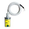
Its simple design assures trouble-free operation, yet provides accurate rainfall measurements. The tipping bucket has an 8" orifice and is shipped complete with mounting brackets and 25 ft. of 2-conductor cable. The tipping bucket sensor mechanism activates a sealed reed switch that produces a contact closure for each 0.01" or 0.2 mm of rainfall. The tipping bucket rain gauge can be pole-mounted or bolted to a level plate.
- Capacity: Unlimited
- Accuracy: +/-1% at 1 inch per hour
- Average Switch Closure Time: 135 ms
- Maximum Bounce Settling Time: 0.75 ms
- Maximum Switch Rating: 30 VDC @ 2A, 115 VAC @ 1 A
- Operating Temperature: 32 to +123.8 F (0 to +51 C)
- Dimensions: 10.125" x 8" inch (26cm x 20cm)
- Shipping Weight: 8 lbs. (3.6 kg)
- Cable: 25 ft (7.6 m), 2 conductor
- (1) Tipping bucket rain gauge
- (1) Set of mounting brackets
- (1) 25 ft. length of 2-conductor cable
Select Options


In The News

Desert Weather Extremes Create Plant Winners And Losers
Researchers at Arizona State University, studying in the Chihuahan desert of New Mexico, have made some interesting finds related to ecosystem “tipping points.” The term refers to the points at which areas are changed beyond what is typical for them, practically creating new ecosystems where some life forms dominate and others falter. The scientists approached the issue by setting up 50 different study plots in the desert. These were laid out within the Jornada Basin Long Term Ecological Research site and incorporated gear like tipping bucket rain gauges, data loggers and custom constructions that redirected and cut off water as needed for study treatments.
Read More
Sargassum Surge: How Seaweed is Transforming our Oceans and Coastal Ecosystems
Until recently, Sargassum –a free-floating seaweed–was distributed throughout the Sargasso Sea , the north Caribbean Sea, and the Gulf of Mexico. But in the space of a decade, this seaweed has, as one scientist remarks , “Gone from a nonfactor to the source of a terrible crisis.” Driven by climate change, anomalous North Atlantic Oscillation in 2009-2010 and a glut of anthropogenic pollutants, sargassum has proliferated. Seasonally recurrent mats as deep as 7m now bloom in the “Great Atlantic Sargassum Belt” (GASB), which covers areas of the Atlantic from West Africa to the Caribbean Sea and Gulf of Mexico. Every year, millions of tons wash up along the shores of more than 30 countries . Dr.
Read More
Great Lakes Research Center: Designing Targeted Monitoring Solutions
According to the National Oceanic and Atmospheric Administration ( NOAA ), the Great Lakes have more miles of coastline than the contiguous Atlantic and Pacific coasts combined and contain 20 percent of the world's freshwater, making it a critical region to protect and conserve. Continuous monitoring and data-informed resource management are key components of managing waters in the region. Hayden Henderson, a research engineer with the Great Lakes Research Center (GLRC), designs and deploys monitoring platforms throughout the Great Lakes. With a background in environmental engineering, Henderson enjoyed the challenge of creating systems and making them work to obtain difficult, remote measurements.
Read More