
Global Water WQ-COND Conductivity Sensor
Features
- Fully encapsulated electronics
- 4-20 mA output
- Select from multiple conductivity ranges
- Free ground shipping
- Expedited repair and warranty service
- Lifetime technical support
- More
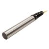
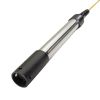
The Global Water WQ-COND Conductivity Sensors are suitable for measuring conductivity in a wide variety of applications including laboratories, streams, rivers, and groundwater. The conductivity sensor's small size and rugged housing make it useful for handheld measurements or permanent installation.
The conductivity sensors use a 4-electrode measuring technique that provides accurate readings over a wide range of conductivities and temperatures. Because the conductivity of ionic solutions increases with increasing temperature, a temperature sensor is also incorporated and is used to provide automatic temperature compensation of 2%/°C normalized to 25°C. An in-line interface module converts the digital conductivity sensor and temperature data into two separate 4-20mA signals for monitoring with data loggers and PLC devices.
The standard conductivity sensors come with three feet (one meter) of cable between the conductivity sensor and interface module, and 25 feet of marine-grade cable for connecting to recording devices. Available conductivity ranges are 200-2000µS/cm and 2-20mS/cm. The conductivity sensor's temperature output has a measurement range of -5°C to +70°C.
| Specifications | |
|---|---|
| Conductivity Ranges | 200 to 2000 µS/cm 2 to 20 mS/cm |
| Temperature Range |
23 to 158°F (-5 to 70°C) |
| Conductivity Accuracy | +0.5% of reading |
| Temperature Accuracy |
+0.4ºF (+0.2ºC) |
| Conductivity Resolution | 1 µS/cm 0.01 mS/cm |
|
Temperature Resolution |
0.02°F (0.01°C) |
| Output |
Dual 4-20 mA |
| Temperature Response | 99% in <20 seconds |
| Maximum Pressure |
35 psi (82 ft (25m)) |
| Immersion Depth | 1.4 inches (36 mm) |
| Operating Voltage |
10-36 VDC |
| Current Draw |
20 mA plus the sum of both sensor outputs |
| Warm-Up Time | 3 seconds minimum |
| Operating Temperature |
23 to +158°F (-5 to +70°C) |
| Storage Temperature | -4 to +212°F (-20 to +100°C) |
| Dimensions |
8 inch L x 0.86 inch Diameter (202 mm L x 22 cm Dia.) |
| Weight |
8 oz (227 g) plus cable |
Select Options


In The News

Supplying Seattle’s Drinking Water: Using Data Buoys to Monitor the Cedar River Municipal Watershed
Providing clean, safe, and reliable drinking water for the 1.6 million people in the greater Seattle area is a top priority for Seattle Public Utilities (SPU). With limited water supplies, SPU dedicates considerable resources to maintain its watersheds and mountain reservoirs. About 70 percent of Seattle Water comes from the Cedar River Municipal Watershed , and the other 30 percent comes from the South Fork Tolt River Watershed . [caption id="attachment_39574" align="alignnone" width="940"] Data buoy in Chester Morse Lake . (Credit: Kevin Johnson / Seattle Public Utilities) [/caption] Jamie Thompson, a fisheries biologist at SPU, monitors aquatic ecosystems centered on fish listed under the U.S. Endangered Species Act (ESA).
Read More
Data-Driven Advocacy on the Lower Deschutes River
Like many freshwater environments, the Deschutes River in Oregon is under pressure from development, pollution, and climate change. Many rivers, streams and lakes in the Deschutes Basin do not meet Oregon water quality standards –where state water quality monitoring assesses levels of bacteria, pH, dissolved oxygen, temperature, and fine sediment. Hannah Camel is the Water Quality Coordinator for the Deschutes River Alliance (DRA), a non-profit organization that focuses on the health of the lower 100 miles of the Deschutes River–the area most affected by human intervention. As a data-driven organization, the DRA has benefited from the installation of two NexSens X2 data loggers.
Read More
Expanding the Port Everglades: Real-Time Monitoring of Water Quality Conditions from Planned Dredging Operation
The Port Everglades in Broward County, Florida, serves large trade vessels and cruiseliners and incoming and outgoing recreational boaters. However, as cargo ships become larger, the port must expand. A dredging project led by the US Army Corps of Engineers will substantially deepen and widen the port's navigation channel to accommodate larger Panamax cargo ships and modern cruise liners. As a result of this project, a large amount of sediment will be displaced into the water column. This suspended sediment may settle outside of the project area, burying benthic organisms like corals, and possibly carrying harmful particulates to other regions. [caption id="attachment_39497" align="aligncenter" width="2560"] A CB-950 and CB-25 deployed on site at Port Everglades.
Read More