
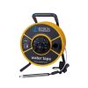
Heron dipper-T2 Water Level Meters
Features
- IP65 electronic module with selectable modes for static and drawDown levels
- IP68 probe is fully pressure/depth rated, no holes or recesses for contaminate build up
- High tensile steel polyethylene tape for stretch-resistance and lifelong legibility
- Free ground shipping
- Expedited repair and warranty service
- Lifetime technical support
- More
Overview
The dipper-T2 is a rugged and dependable water level meter made from high-quality materials, easy to use for a wide variety of applications. The dipper-T2 is capable of measuring both static and falling head levels. Static mode is used for measuring the depth of water in wells, boreholes, and standpipes. DrawDown mode is used to measure falling water levels during purging, well development, and low flow sampling, helping to protect the pump from damage caused by dry running.
Choice of Steel Tape
The Heron dipper-T2 is renowned for its premium, polyethylene-coated yellow steel tape accuracy in measuring depth to water. Available in metric or engineering scale.
- Premium Stainless Steel Polyethylene Coated Tape
- 5/8” (15.9mm) Water Level Probe (IP68) w/ holder
- Electronic Panel with audio and visual signals (Fully Encapsulated to IP65)
- Sensitivity dial to tune out cascading water
- Vinyl, ergonomic holding grip
- 9V Battery
- Backpack Carrying Case w/ adjustable straps, laptop & notepad pouches
Select Options


In The News

Monitoring Mariculture in the Gulf of Alaska
The mariculture industry in the Gulf of Alaska has been steadily growing in recent years, guided by ongoing research to help refine farm location and cultivation practices. A subset of aquaculture, mariculture focuses on rearing organisms in the open ocean. In Alaska, finfish farming is illegal, so most farms cultivate kelp, oysters, or a combination of the two. These small, locally operated farms started popping up in the Gulf of Alaska in the early 1990s, when shellfish farming first became legal. Kelp farming did not begin to catch on in the state until 2016. Many of the coastal areas that have grown interested in mariculture are historically commercial fishing communities.
Read More
Supplying Seattle’s Drinking Water: Using Data Buoys to Monitor the Cedar River Municipal Watershed
Providing clean, safe, and reliable drinking water for the 1.6 million people in the greater Seattle area is a top priority for Seattle Public Utilities (SPU). With limited water supplies, SPU dedicates considerable resources to maintain its watersheds and mountain reservoirs. About 70 percent of Seattle Water comes from the Cedar River Municipal Watershed , and the other 30 percent comes from the South Fork Tolt River Watershed . [caption id="attachment_39574" align="alignnone" width="940"] Data buoy in Chester Morse Lake . (Credit: Kevin Johnson / Seattle Public Utilities) [/caption] Jamie Thompson, a fisheries biologist at SPU, monitors aquatic ecosystems centered on fish listed under the U.S. Endangered Species Act (ESA).
Read More
Data-Driven Advocacy on the Lower Deschutes River
Like many freshwater environments, the Deschutes River in Oregon is under pressure from development, pollution, and climate change. Many rivers, streams and lakes in the Deschutes Basin do not meet Oregon water quality standards –where state water quality monitoring assesses levels of bacteria, pH, dissolved oxygen, temperature, and fine sediment. Hannah Camel is the Water Quality Coordinator for the Deschutes River Alliance (DRA), a non-profit organization that focuses on the health of the lower 100 miles of the Deschutes River–the area most affected by human intervention. As a data-driven organization, the DRA has benefited from the installation of two NexSens X2 data loggers.
Read More