
Heron dipperLog VENTED+ Water Level Logger
Features
- Automatic barometric pressure compensation using vented cable
- Easy-to-use software for deployment, data upload & data management
- Vented cable is removable for easy field replacement
- Free ground shipping
- Expedited repair and warranty service
- Lifetime technical support
- More
Overview
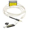
The Heron dipperLog VENTED+ Water Level Logger is a reliable, cost effective solution for measuring groundwater levels and temperature in wells, boreholes and open bodies of water. The dipperLog VENTED+, incorporates a gauged transducer that measures pressure exempt from barometric influences which is ideal to use in both long and short term monitoring.
Design
The vented data logger is now removable from the vent cable allowing for easy field replacement and other deployment applications. The new Vent Cap Adaptor, especially designed for shallow applications, allows for a true collection of water level measurements without performing barometric compensation. By utilizing the Vent Cap Adaptor, a dipperLog VENTED+ can be deployed in wetlands or overflow ditches without a vent cable. This cap is specifically designed to allow the barometric pressure to be measured accurately when the cap is exposed while sealing the logger from water intrusion when the cap becomes submerged.
Select Options


In The News

Supplying Seattle’s Drinking Water: Using Data Buoys to Monitor the Cedar River Municipal Watershed
Providing clean, safe, and reliable drinking water for the 1.6 million people in the greater Seattle area is a top priority for Seattle Public Utilities (SPU). With limited water supplies, SPU dedicates considerable resources to maintain its watersheds and mountain reservoirs. About 70 percent of Seattle Water comes from the Cedar River Municipal Watershed , and the other 30 percent comes from the South Fork Tolt River Watershed . [caption id="attachment_39574" align="alignnone" width="940"] Data buoy in Chester Morse Lake . (Credit: Kevin Johnson / Seattle Public Utilities) [/caption] Jamie Thompson, a fisheries biologist at SPU, monitors aquatic ecosystems centered on fish listed under the U.S. Endangered Species Act (ESA).
Read More
Data-Driven Advocacy on the Lower Deschutes River
Like many freshwater environments, the Deschutes River in Oregon is under pressure from development, pollution, and climate change. Many rivers, streams and lakes in the Deschutes Basin do not meet Oregon water quality standards –where state water quality monitoring assesses levels of bacteria, pH, dissolved oxygen, temperature, and fine sediment. Hannah Camel is the Water Quality Coordinator for the Deschutes River Alliance (DRA), a non-profit organization that focuses on the health of the lower 100 miles of the Deschutes River–the area most affected by human intervention. As a data-driven organization, the DRA has benefited from the installation of two NexSens X2 data loggers.
Read More
Expanding the Port Everglades: Real-Time Monitoring of Water Quality Conditions from Planned Dredging Operation
The Port Everglades in Broward County, Florida, serves large trade vessels and cruiseliners and incoming and outgoing recreational boaters. However, as cargo ships become larger, the port must expand. A dredging project led by the US Army Corps of Engineers will substantially deepen and widen the port's navigation channel to accommodate larger Panamax cargo ships and modern cruise liners. As a result of this project, a large amount of sediment will be displaced into the water column. This suspended sediment may settle outside of the project area, burying benthic organisms like corals, and possibly carrying harmful particulates to other regions. [caption id="attachment_39497" align="aligncenter" width="2560"] A CB-950 and CB-25 deployed on site at Port Everglades.
Read More