
Juniper Geode GNSS Receivers
Features
- Compatible with iOS, Android, and Windows devices
- Intuitive and easy operation, one-button simplicity
- All day battery life for long work days in the field
- Free ground shipping
- Expedited repair and warranty service
- Lifetime technical support
- More
Scalable Accuracy
The Geode GNS3 provides sub-meter, sub-foot, decimeter and centimeter accuracy options which include SBAS Corrections, RTK, Atlas, and the new Galileo High Accuracy Service.
Open Interface (BYOD)
Use Geode with any of Juniper Systems' handhelds or with your own iPhone™, iPad™, Windows®, or Android™ device.
All-day Battery Life
The Overtime Technology battery provides enough power for long workdays, while conserving power in extreme temperatures.
Simple to Use
It's "one button simple" design provides intuitive and easy operation.
Compact Size
Small and lightweight, the Geode is easy to pack around all day.
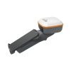
All-In-One Design
The inside of the Geode contains the receiver, antenna, and battery, making it easy to carry around and mount without a mess of wires.
Juniper Rugged™
Designed to withstand harsh environments for consistently reliable performance.
Galileo High Accuracy Service (HAS)
The new GNS3H model of the Geode family adds support for the Galileo High Accuracy Service (HAS) to provide free, worldwide 20cm accurate positioning. The Galileo HAS is currently in Initial Phase, meaning that the performance and time standards are currently relaxed so that the EUSPA (European Union Agency for Space Programme) can complete their design and testing to complete the Final Phase of operations with better than 20cm performance in under 5 minutes convergence time (see excluded areas in map below). Simply apply a multi-frequency upgrade to any GNS3H receiver and you have instant access to 20cm real-time location accuracy without any additional subscriptions, downloads or software. The Galileo High Accuracy Service provides precise corrections in the Galileo E6B data signal so that Galileo and GPS signals can achieve real time positioning performance of better than 20cm in nominal conditions. With Galileo HAS, Sub-meter becomes Sub-foot as the new standard for free and open global GNSS positioning.
RECEIVER
- Receiver Type: multi-frequency multi-constellation and L-band capable
- Signals: GPS: L1CA, L1P, L1C, L2P, L12P, L2C, L5,
GLONASS: G1, G2, BeiDou: B1, B2, B3,
GALILEO: E1BC, E5a, E5b, E6b and
QZSS: L1CAm, L1C, L2C, L5 - Channels: 800+
- SBAS Support: 3-channel parallel tracking
- L Band: Atlas worldwide 1525-1560 Mhz
(with subscription) - Update Rate: 1 Hz standard, up to 10Hz and 20 Hz options
- Galileo High Accuracy Service support (GNS3H, with multi-frequency enabled)
ACCURACY
- SBAS: 30 cm HRMS, <60 cm 2DRMS
- RTK: 1 cm RMS
- Atlas (95%): H10:10cm, H30:30 cm, Basic:
50cm (requires subscription)
GALHAS (95%): 20cm - Autonomous: 1.2 meters HRMS
- Cold Start: <60 sec typical (no almanac)
- Reacquisition: 15 sec Atlas, all others <1sec
COMMUNICATIONS
- Bluetooth® 5.1 SPP, IAP2, EAP
- Bluetooth Range: Class 1 Long Range
- Ports: USB Type-C; Serial RS232C DB-9
- Serial Baud Rates: 4800-115200
RECEIVER PROTOCOLS
- Data I/O Protocol: NMEA 0183, Crescent Raw Binary (proprietary)
- Correction I/O Protocol: Hemisphere GNSS
Proprietary, ROX, RTCM v2.3, RTCM v3.2, CMR,
CMR+ - Other: 1PPS Timing Output, Speed Pulse,
Event Marker Input (optional)
POWER
- Input Voltage: 5VDC @ 2A USB
- Power Consumption : 1.7-2 W nominal
- Overtime Technology™ Battery:3.6V 6000 mAh Li-ion (GNS3M/GNS3H) 10 hours, (GNS3S) 16 hours
- Charging Time: Less than 4 hours
ANTENNA
- Internal precision single/multi-frequency with integrated ground plane
- External Antenna Port: MCX type, 50 ohm 15VDC @ 45 mA maximum (GNS3M)/20mA maxiumum (GNS3S)
JUNIPER RUGGED™
- Operating Temp: -20 C to +60 C
- Storage Temp: -30 C to +60 C
- Meets or Exceeds MIL-STD 810G (Drop, Vibration, Temperature, Ingress Protection)
- Enclosure Rating: IP68 (1.4 meters for 30 min)
RECEIVER UPGRADES
- 10 Hz Data Rate
- 20 Hz Data Rate
- Multi-Frequency
- Atlas Basic
- Atlas H30
- Atlas H10
- Athena RTK Engine
DIMENSIONS
- 110x110x57mm (4.36x4.36x2.5in)
- GNS3S Weight: 365g (12.9oz)
- GNS3M/GNS3H Weight: 405g (14.3oz)
- Mount: ¼ x 20 camera stud and M4 AMPS diagonal
GEODE GNS3 COMPATIBILITY
- GeodeConnect™ software provides configuration, communications setup, and receiver settings
- Windows® 10/11
- Android™ 8 and above
- iPhone and iPad
- (1) Geode GNSS receiver with integrated antenna and battery
- (1) USB Type-C to USB Type-C cable
- (1) 5/8 x 11 pole mount adapter
- (1) USB charger
Select Options


In The News
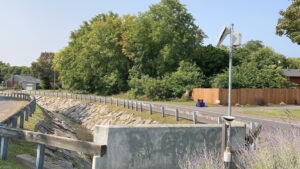
Monitoring Meadowbrook Creek: Real-Time Data Collection in an Urban Creek
Meadowbrook Creek in Syracuse, New York, has been monitored by Syracuse University (SU) faculty and students for over a decade. Originally established by Dr. Laura Lautz in 2012, the early years of the program focused on collecting grab water samples for laboratory analysis and evaluating the impact of urban land use, human activities, and natural processes on water resources. Tao Wen , an Assistant Professor in SU’s Department of Earth and Environmental Sciences, took over the program in 2020 and upgraded the existing systems to include 4G modems that allowed for real-time data viewing. [caption id="attachment_39339" align="alignnone" width="940"] An overview of the Fellows Ave monitoring station along Meadowbrook Creek.
Read More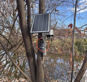
Lancaster County Makes the Switch to Real-Time Water Quality Monitoring Systems
Continuous data collection in Lancaster County, Pennsylvania, started about 5 years ago, and the county will be making a major upgrade over the next year—switching from relying solely on the internal storage of water quality sondes to telemetry units that enable real-time data viewing. [caption id="attachment_39295" align="alignnone" width="940"] The first telemetry unit was installed at LCCD along Little Conestoga Creek. (Credit: Tyler Keefer / LCCD) [/caption] Telling Lancaster County's Story Through Data Since the Lancaster County Conservation District started monitoring county waterways, the goal has remained the same, according to Amanda Goldsmith, Watershed Specialist for the Watershed Department.
Read More
From Florida to the World: How a Smithsonian Research Station is Bridging Gaps in Marine Biology
In the early 2000s, along the coast of northern California, where the redwoods dominate the forests, and the Pacific Ocean shapes shorelines, a Humboldt University undergraduate student took the first steps into a lifelong love of marine biology. Dean Janiak accepted an invitation to help a graduate student with fieldwork in rocky coastal tide pools, and so began a journey that led him from California to Connecticut to Florida and eventually to the world, where he has facilitated research in communities across the globe. While finishing up his masters of Oceanography from the University of Connecticut, Janiak continued researching fouling communities–marine life that live on hard, often artificial surfaces such as docks–at the Smithsonian Environmental Research Center.
Read More