
KestrelMet 6000 Wireless Weather Stations
Features
- Measures key weather parameters with wireless Wi-Fi or cellular communication
- Optional leaf wetness, solar irradiance, and soil moisture sensors
- First year of cellular data plan is included at no additional cost
- Expedited repair and warranty service
- Lifetime technical support
- More
Overview
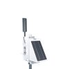
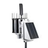
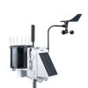
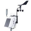
The KestrelMet 6000 is a reliable cost-effective all-in-one professional weather station for commercial, industrial, educational, and research applications. Easily deployable and remote, the KestrelMet arrives pre-assembled for fast set up and frustration-free installation. Cellular versions of the KestrelMet 6000 include a low-cost cellular plan with the first year free.
Mounting Options
Choose between the Mono Mount Kit or the Tripod Mount Kit to best fit research needs. Both options offer quick installation and a secure mounting system. The Mono Mount can be used on a pitched or flat roof as well as a vertical surface such as a gable end. The Tripod can be used on flat terrain, on a flat roof, or on the ridge of a pitched roof.
Design
Solar radiation can cause measurement errors and reduce sensor accuracy. Shielding over the air temperature and relative humidity sensors and a 24-hour aspirated fan keep air moving constantly over the sensors. This results in a significant improvement in measurement accuracy versus passive-shielded weather stations with no aspiration fan.
*Note: cellular transmission is set at 15-minute intervals.
| Sensors | Accuracy (+/- | Resolution | Range | Notes |
| Wind Speed | larger of 5% or 1 mph between 1 to 57 mph | 0.1 mph 0.1 knot 0.1m/s 0.1 km/hr |
1 to 100 mph 1 to 86.9 knots 1 to 44.7 m/s 1 to 160.9 km/hr |
Wind speed is measured continuously and stored in station memory as a series of 2 second averages. The reported wind speed is the average over the 15 minute logging interval. The highest measured speed during the logging interval is reported as the gust value. |
| Wind Direction | 2° | 1° | 1° - 360° | Wind direction is measured continuously and stored in station memory as a series of 2 second averages. The reported wind direction is the average scalar direction over the 15 minute logging interval. The gust direction is the average scalar direction for the 2 second record corresponding to the gust value. |
| Temperature |
0.45° F |
0.1° F 0.1° C |
-40° to 140° F -40° to 60° C |
Temperature is measured once per minute. The reported temperature is the average value for the 15 minute logging interval. High and low temperatures are based on the 1-minute readings. |
| Relative Humidity | 1.5% between 0 - 80% | 1% | 0 to 100% | Humidity is measured once per minute. The reported humidity is the average value for the 15 minute logging interval. High and low RH are based on the 1-minute readings. |
| Absolute Pressure | 1.5 mbar/hPa 0.044 inHg 1.1 mmHg |
0.1 mbar/hPa 0.01 inHg 0.1 mmHg |
600 to 1100 mbar/hPa 17. 72 to 32.48 inHg 450.0 to 825.1 mmHg |
Pressure is measured once per minute. The reported pressure is the average value for the logging interval. High and low pressures are based on the 1-minute readings. |
| Rain Rate | 5% at 2"/hr | 0.01 in/hr 0.1 mm/hr |
0 to 7.8 in/hr | Rainfall is measured continuously in 0.2 mm increments (tipping bucket calibration volume) |
Select Options


In The News

Spring 2025 Environmental Monitor Available Now
In the Spring 2025 edition of the Environmental Monitor, we highlight partnerships across the world and the importance of collaboration between government agencies, universities, environmental groups, local communities, and other stakeholders. From great white shark research in Cape Cod to monitoring fisheries in Lake Erie, this latest edition underscores partnerships that connect stakeholders in a watershed through environmental data. With an emphasis on data sharing, a combination of real-time and discrete sampling keeps the public and partners informed of environmental conditions. Our writers also sought out science professionals dedicated to working with peers within and outside of the environmental sector.
Read More
Monitoring Mariculture in the Gulf of Alaska
The mariculture industry in the Gulf of Alaska has been steadily growing in recent years, guided by ongoing research to help refine farm location and cultivation practices. A subset of aquaculture, mariculture focuses on rearing organisms in the open ocean. In Alaska, finfish farming is illegal, so most farms cultivate kelp, oysters, or a combination of the two. These small, locally operated farms started popping up in the Gulf of Alaska in the early 1990s, when shellfish farming first became legal. Kelp farming did not begin to catch on in the state until 2016. Many of the coastal areas that have grown interested in mariculture are historically commercial fishing communities.
Read More
Supplying Seattle’s Drinking Water: Using Data Buoys to Monitor the Cedar River Municipal Watershed
Providing clean, safe, and reliable drinking water for the 1.6 million people in the greater Seattle area is a top priority for Seattle Public Utilities (SPU). With limited water supplies, SPU dedicates considerable resources to maintain its watersheds and mountain reservoirs. About 70 percent of Seattle Water comes from the Cedar River Municipal Watershed , and the other 30 percent comes from the South Fork Tolt River Watershed . [caption id="attachment_39574" align="alignnone" width="940"] Data buoy in Chester Morse Lake . (Credit: Kevin Johnson / Seattle Public Utilities) [/caption] Jamie Thompson, a fisheries biologist at SPU, monitors aquatic ecosystems centered on fish listed under the U.S. Endangered Species Act (ESA).
Read More