
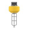
NexSens CB-75-SVS Wave Buoy
Features
- Measures wave height, period & direction
- Designed for tethered moorings
- Integrated SeaView Systems SVS-603HR wave sensor
- Expedited repair and warranty service
- Lifetime technical support
- More
The CB-75-SVS Wave Buoy offers the latest in real-time wave observations in a compact, affordable, and easy to deploy platform. At 21” (53.34cm) hull diameter and 40 lb. (18.14kg) weight, it’s ideally suited for tethered moorings. The buoy accurately measures wave height, period, direction, and more using SeaView Systems’ industry-leading SVS-603HR sensor, relied upon in buoy networks by NOAA and many others throughout the world. External sensor ports with wet-mate connectors support GPS, meteorological, and water quality sensors for maximum flexibility.
The buoy is constructed of an inner core of cross-linked polyethylene foam with a tough polyurea skin. A rechargeable battery with integrated solar panels powers the wave buoy continuously, and all electronics are housed in a quick-removable waterproof package with wet-mate connectors. A removeable instrument cage serves as counter-ballast and supports instrument mounting, while three 1.5” (3.81cm) pass-through holes facilitate cable routing of underwater sensors.
Available with integrated 4G LTE or Iridium satellite communications, the CB-75-SVS Wave Buoy sends data in real-time to the cloud-based WQData LIVE datacenter. In the Basic tier, this free service allows users to securely access and analyze data, as well as share data through an auto-report. Subscription-based tiers of WQData LIVE are also available for generating custom alarms, exporting data through an API or custom NDBC/GLOS formats, and providing a publicly-accessible version of the project website.
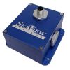
Wave Sensor: SeaView Systems SVS-603HRi
Parameters: Hs Wave Height (Significant Wave Height), TP (DPD) Wave Period, Dominant Wave Direction, Mean Wave Direction (MWD), Te Energy Period, RMS Tilt Angle, Max Tilt Angle
Range: Wave Height: 0.2-20m; Wave Period: 1.5-20 seconds; Wave Direction: 0-360°
Resolution: Wave Height: 0.001m; Wave Period: 0.001 seconds; Wave Direction: 0.001°
Accuracy: Wave Height: +/- 0.5cm; Wave Period: <1%; Wave Direction: +/-2°
Buoy: NexSens CB-75
Hull Outer Diameter: 21” (53.34cm)
Hull Height: 13” (33.02cm)
Tower Height: 8.2” (20.83cm)
Solar Panels: 3x 4-watts
Weight: 40 lb. (18.20kg)
Net Buoyancy: 75 lb. (34.00kg)
Tethering Attachments: 3x 3/8” eye nuts
Data Logger: NexSens X3-SVS
Operating Temperature: -40°C to 70°C
Rating: IP68
User Interface: Wireless Bluetooth or wired RS-485 via USB adapter to CONNECT Software; WQData LIVE Web Datacenter with optional wireless telemetry; Status beeps
Real Time Clock (RTC): <30sec/month drift1; Auto-sync weekly2; Internal backup battery
Data Logging: 8 MB non-volatile flash memory; >1 year storage with 20 parameters at 15-minute interval; Max 200 parameters per log interval
Log Interval: User configurable from 5-minute (20-minute default)3; Unique interval per sensor
Transmit Interval: User configurable from 5-minute (10-minute default)
Transmission Trigger: Time-based; Selective parameter upload option
Sensor Interfaces: RS-232 (2 Channels), SDI-12, RS-485, Pulse Count
Built-in Sensors: Temperature (-40° to 100°C, 0.016°C resolution, ±0.3°C accuracy); Humidity (0% to 100%, 0.03% resolution, ±4% accuracy from 5 to 95% RH; System voltage; System current; System power; Real-time clock (RTC) battery voltage
Sensor Ports: (2) MCBH-8-MP for sensor interface (RS-232, RS-485, SDI-12, Power, GND)
Power Port: (1) MCBH-6-FS for power and communication (12V Solar In, Power Switch, RS-485 Host, GND)
Telemetry Options: 4G LTE global cellular; Iridium satellite
Antenna Port: Type N female
Notes
1Assumes 25ºC operating temperature
2Requires the X3-SVS to be connected to the internet
3Minimum log interval dependent on sensor limitations and processing time
Select Options


In The News

Protecting Chicago's Lakefront: Freshwater Beach Monitoring
Thousands of people flock to the Great Lakes every year to enjoy the freshwater beaches along the coast. As an urban hub with over 2.5 million residents, beachfronts in Chicago have regular visitors as well as tourists that recreate in the bordering Lake Michigan. According to the Chicago Park District, it is estimated that more than 100,000 residents and visitors per day use Chicago’s Lakefront trail during summer weekends. Proximity to the Lake is not only a recreational activity for Chicagoans, but also a part of the city’s history due to its role in domestic and international shipping routes. In addition, the Lake serves as a drinking water source and as an essential climate regulator in the region that acts as a natural air conditioning affect.
Read More
It’s Time to React to Water Quality: Proteus Multiparameter Probe aboard NexSens Buoy
Water quality monitoring is essential for safeguarding public health, protecting ecosystems, and ensuring the sustainability of water resources. Contaminants such as industrial pollutants, agricultural runoff, and sewage discharge can severely impact aquatic life and pose serious risks to human health if left unchecked. Traditionally, water quality monitoring has been a slow and labor-intensive process, requiring samples to be collected, transported to a lab, and analyzed—a process that can take days. However, with the advancement of real-time sensor technology, environmental agencies, researchers, and industries can now monitor water quality instantly.
Read More
Safeguarding Communities with Real-Time Flood Monitoring in the City of Hazelwood
The City of Hazelwood is a suburb in St. Louis County, Missouri, home to around 25,500 people. Recently, the community has suffered increased flash flooding following severe storms, prompting the need for the installation of a flood monitoring system. In 2022, a NexSens X2 data logger was installed to monitor water level and rainfall in real-time, with the aim of reducing the loss of life and property as a result of extreme weather events. [caption id="attachment_39411" align="alignnone" width="940"] The latest flood event at Coldwater Creek, where the water level rose by 14 feet, exceeding the height of the X2 by three feet. The sensor can be seen behind the wall that usually contains the Creek.
Read More