
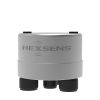
NexSens X3-SUB Submersible Data Logger
Features
- Wet-mateable sensor and power ports with integrated wireless communications
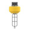
- Optimized for use with CB-75 data buoy for monitoring water or atmospheric conditions
- Withstands extreme wave action, floods, and periodic & long-term deployment underwater
- Free ground shipping
- Expedited repair and warranty service
- Lifetime technical support
- More
The X3-SUB Submersible Data Logger is a rugged, self-powered remote data logging system specifically designed for offshore use without fear of accidental flooding. The system is configured with three sensor ports for connection to most environmental sensors including multiparameter sondes, water quality sensors, temperature strings, ADCP’s, water level sensors, and weather stations. All connections are made using MCIL/MCBH wet-mate connectors, and the built-in sensor library automatically facilitates setup and configuration. Sensor data is recorded on common or independent schedules.
Unlike many data loggers, the X3-SUB can withstand extreme wave action, floods, periodic & long-term deployment underwater, and more. The Type 316 stainless steel housing is completely sealed and waterproof for long-term sub-surface data logging. When fitted for wireless remote communication, the cellular and satellite antennas are also waterproof. The X3-SUB can be powered by internal SLA battery, alkaline battery pack, or external 12 VDC power. The internal SLA battery is intended for use with the CB-75 Data Buoy for continuous power via solar charging.
Using Bluetooth or a USB adapter and CONNECT Software, users can configure the X3-SUB data logger for deployment, view live data, change settings, or troubleshoot. Optional integrated 4G LTE cellular or Iridium satellite telemetry modules offer 2-way remote communications via the WQData LIVE Web Datacenter. There, data is presented on a fully-featured and easy-to-use dashboard. Other features include automated reports, email/text alarms, public portal, API, and much more.
Material: Type 316 stainless steel
Weight: 8.2 lbs. (3.72kg); 12.2 lbs. (5.53kg) with rechargeable battery; 14.1 lbs. (6.40kg) with alkaline battery
Dimensions: 5.5" (13.97cm) diameter with 7.25” (18.42cm) flange x 14.63" (37.16cm) height
Internal Power Options: 6 A-Hr SLA rechargeable battery or 20 D-cell alkaline battery pack
External Power Requirements: 10.7 to 16.8 VDC +/-5%; includes reverse polarity protection, over voltage protection (OVP), and under voltage lock out (UVLO) protection
Current Draw (Typical @ 12VDC): Sleep: 450uA; Active: 55mA; Cellular transmitting: 300mA; Iridium satellite transmitting: 170mA
Peak Current: Power supply must be able to sustain a 500mA 1-second peak current (@ 12V)
Operating Temperature: -40°C to 70°C
Rating: IP68
User Interface: Wireless Bluetooth or wired RS-485 via USB adapter to CONNECT Software; WQData LIVE Web Datacenter with optional wireless telemetry; Status beeps
Real Time Clock (RTC): <30sec/month drift1; Auto-sync weekly2; Internal backup battery
Data Logging: 8 MB non-volatile flash memory; >1 year storage with 20 parameters at 15-minute interval; Max 200 parameters per log interval
Log Interval: User configurable from 1-minute (10-minute default)3; Unique interval per sensor
Transmit Interval: User configurable from 5-minute (10-minute default)
Transmission Trigger: Time-based; Selective parameter upload option
Sensor Interfaces: RS-232 (3 Channels), SDI-12, RS-485, Pulse Count
Sensor Power: (2) independent switches from input supply4,5
Built-in Sensors: Temperature (-40° to 100°C, 0.016°C resolution, ±0.3°C accuracy); Humidity (0% to 100%, 0.03% resolution, ±4% accuracy from 5 to 95% RH; System voltage; System current; System power; Real-time clock (RTC) battery voltage
Sensor Ports: (3) MCBH-8-MP for sensor interface (RS-232, RS-485, SDI-12, Power, GND)
Power Port: (1) MCBH-6-FS for power and communication (12V Solar In, Power Switch, RS-485 Host, GND)
Telemetry Options: 4G LTE global cellular; Iridium satellite
Antenna Port: Type N female
Notes
1Assumes 25ºC operating temperature
2Requires the X3-SUB to be connected to the internet
3Minimum log interval dependent on sensor limitations and processing time
4Cumulative concurrent current limit of all three channels is 2A
5Logger power supply must be able to support current requirements of sensors
Select Options


In The News

Protecting Natural Resources: Long-Term Monitoring in Acadia National Park
The United States' national parks are visited by millions of people each year, providing opportunities to experience the local beauty of the U.S. A core mission of the National Park Service (NPS) is to protect and preserve these unique areas since they are not totally free of pollution and the influence of climate change. As such, national parks are the site of many environmental monitoring programs designed to assess the effects of global stressors like climate change and pollution on park resources. Acadia National Park's water and air monitoring programs are examples of this, providing a long-term data history documenting changes in air and water quality over the past four decades.
Read More
Protecting the Caloosahatchee Estuary: Marine Water Quality Systems in Southwest Florida
The southwest Coast of Florida is home to an incredible array of natural wonders, from the Florida Everglades to the Pine Island Sound Aquatic Preserve and the many miles of coastline in between. Yet there is also a high density of urbanization in this region, stretching from Fort Myers to Cape Coral and down to Marco Island, with an estimated population of 1.4 million, much within coastal watersheds, according to the Lee County Economic Development Office . Many inland rivers that run through this area of the state drain into the Gulf of Mexico. One of these is the Caloosahatchee River, which forms an estuary just past Cape Coral out towards Pine and Sanibel Islands.
Read More
Sargassum Surge: How Seaweed is Transforming our Oceans and Coastal Ecosystems
Until recently, Sargassum –a free-floating seaweed–was distributed throughout the Sargasso Sea , the north Caribbean Sea, and the Gulf of Mexico. But in the space of a decade, this seaweed has, as one scientist remarks , “Gone from a nonfactor to the source of a terrible crisis.” Driven by climate change, anomalous North Atlantic Oscillation in 2009-2010 and a glut of anthropogenic pollutants, sargassum has proliferated. Seasonally recurrent mats as deep as 7m now bloom in the “Great Atlantic Sargassum Belt” (GASB), which covers areas of the Atlantic from West Africa to the Caribbean Sea and Gulf of Mexico. Every year, millions of tons wash up along the shores of more than 30 countries . Dr.
Read More