
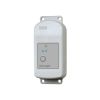
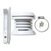
HOBO MX Soil Moisture Loggers
Features
- Ready to deploy, with pre-attached sensors
- Easy configuration and data offload with the free HOBOconnect app
- Durable TEROS 10 soil moisture sensor lasts over 10 years in the field
- Free ground shipping
- Expedited repair and warranty service
- Lifetime technical support
- More
Overview
The Onset HOBO MX Soil Moisture Data Loggers are the industry’s only low-cost, fully integrated soil moisture loggers with Bluetooth wireless data offload. Available in two models--one that measures soil moisture (HOBO MX2306) and one that measures both soil moisture and temperature (HOBO MX2307)--these loggers are ideal for users looking for the accurate data they need to save water, improve crop yields, reduce harmful runoff, and protect ecosystems.
Mechanics
With just a mobile phone, tablet, or Windows laptop running Onset’s free HOBOconnect app, users get convenient wireless setup and data download via Bluetooth when within 100 feet of the logger – making it easy to retrieve data from hard-to-access field locations. For indoor areas, such as greenhouses, users can add the MX Gateway for remote access to data in Onset’s cloud-based HOBOlink software.
| Soil Moisture: Volumetric Water Content (VWC) | |
| Measurement Range |
0.00 to 0.64 m³/m³ in mineral soils 0.00 to 0.70 m³/m³ in soilless media |
| Accuracy |
±0.031 m³/m³ typical in mineral soils that have solution EC <8 dS/m ±0.051 m³/m³ typical in soilless media |
| Resolution |
0.001 m³/m³ |
| Dielectric Measurement Frequency |
70 MHz |
| Temperature Sensor (MX2307) | |
| Range |
-40 to 100°C (-40 to 212°F), with tip and cable immersion in fresh water up to 50°C (122°F) for one year |
| Accuracy |
±0.25°C from -40 to 0°C (±0.45 from -40 to 32°F)
±0.2°C from 0 to 70°C (±0.36 from 32 to 158°F)
±0.25°C from 70 to 100°C (±0.45 from 158 to 212°F)
|
| Resolution |
0.04°C (0.072°F)
|
| Drift |
<0.01°C per year (0.018°F per year)
|
| Response Time |
3 minutes in air moving 1 m/s; 20 seconds in stirred water 4 minutes in air moving 1 m/s with RS3-B Solar Radiation Shield |
| Logger | |
| Operating Range |
-25° to 60°C (-13° to 140°F)
|
| Radio Power |
1 mW (0 dBm)
|
| Transmission Range |
Approximately 30.5 m (100 ft) line-of-sight |
| Wireless Data Standard |
Bluetooth Low Energy (Bluetooth Smart) |
| Logging Rate |
1 second to 18 hours |
| Logging Modes |
Fixed interval (normal, statistics) or burst |
| Memory Modes |
Wrap when full or stop when full |
| Start Modes |
Immediate, push button, date & time, or next interval |
| Stop Modes |
When memory full, push button, date & time, or after a set logging period |
| Time Accuracy |
±1 minute per month 0° to 50°C (32° to 122°F) |
| Battery Type |
2/3 AA 3.6 Volt lithium, user replaceable |
| Battery Life |
2 years, typical with logging interval of 1 minute and Bluetooth Always On enabled; 5 years, typical with logging interval of 1 minute and Bluetooth Always On disabled. Faster logging intervals and statistics sampling intervals, burst logging, remaining connected with the app, excessive downloads, and paging may impact battery life. |
| Memory |
110,000 measurements, maximum (472 kB) |
| Full Memory Download Time |
Approximately 60 seconds; may take longer the further the device is from the logger |
| Dimensions |
Logger housing: 10.8 x 5.08 x 2.24 cm (4.25 x 2.0 x 0.88 in.)
Soil moisture sensor: 7.5 x 5.1 x 2.4 cm (2.95 x 2.02 x 0.95 inches)
Soil moisture sensor needle length: 5.4 cm (2.13 inches) Soil moisture sensor needle diameter: 0.32 cm (0.13 inches) Temperature sensor (MX2307) diameter: 0.53 cm (0.21 in.) Sensor cable length: 2 m (6.56 ft) |
| Weight |
MX2306: 229 g (80 oz) MX2307: 267 g (94 oz) |
| Materials |
Logger: Acetal, silicone gasket, stainless steel screws Soil Moisture Sensor: ASA plastic body with polyurethane epoxy filling and stainless steel pins Temperature Sensor (MX2307): Stainless steel waterproof tip Cable: PVC, UV resistant and rodent repellent (soil moisture sensor cable) |
| Environmental Rating |
Temperature sensor and cable (MX2307): Immersion in water up to 50°C (122°F) for 1 year |
- HOBO MX2306 or HOBO MX2307 Data Logger with 2m cable(s) and attached sensor(s)
- HOBO MX Soil Moisture Logger Quick Start
- Screws
- Cable ties
Select Options


In The News

Supplying Seattle’s Drinking Water: Using Data Buoys to Monitor the Cedar River Municipal Watershed
Providing clean, safe, and reliable drinking water for the 1.6 million people in the greater Seattle area is a top priority for Seattle Public Utilities (SPU). With limited water supplies, SPU dedicates considerable resources to maintain its watersheds and mountain reservoirs. About 70 percent of Seattle Water comes from the Cedar River Municipal Watershed , and the other 30 percent comes from the South Fork Tolt River Watershed . [caption id="attachment_39574" align="alignnone" width="940"] Data buoy in Chester Morse Lake . (Credit: Kevin Johnson / Seattle Public Utilities) [/caption] Jamie Thompson, a fisheries biologist at SPU, monitors aquatic ecosystems centered on fish listed under the U.S. Endangered Species Act (ESA).
Read More
Data-Driven Advocacy on the Lower Deschutes River
Like many freshwater environments, the Deschutes River in Oregon is under pressure from development, pollution, and climate change. Many rivers, streams and lakes in the Deschutes Basin do not meet Oregon water quality standards –where state water quality monitoring assesses levels of bacteria, pH, dissolved oxygen, temperature, and fine sediment. Hannah Camel is the Water Quality Coordinator for the Deschutes River Alliance (DRA), a non-profit organization that focuses on the health of the lower 100 miles of the Deschutes River–the area most affected by human intervention. As a data-driven organization, the DRA has benefited from the installation of two NexSens X2 data loggers.
Read More
Expanding the Port Everglades: Real-Time Monitoring of Water Quality Conditions from Planned Dredging Operation
The Port Everglades in Broward County, Florida, serves large trade vessels and cruiseliners and incoming and outgoing recreational boaters. However, as cargo ships become larger, the port must expand. A dredging project led by the US Army Corps of Engineers will substantially deepen and widen the port's navigation channel to accommodate larger Panamax cargo ships and modern cruise liners. As a result of this project, a large amount of sediment will be displaced into the water column. This suspended sediment may settle outside of the project area, burying benthic organisms like corals, and possibly carrying harmful particulates to other regions. [caption id="attachment_39497" align="aligncenter" width="2560"] A CB-950 and CB-25 deployed on site at Port Everglades.
Read More