
HOBO MX20L Water Level Loggers
Features
- Self-contained, non-vented design enables easy deployment
- Streamlined data offload via Bluetooth to the free HOBOconnect app
- Ideal for use in both freshwater and saltwater environments, including wells, streams, lakes, wetlands, and tidal areas
- Free ground shipping
- Expedited repair and warranty service
- Lifetime technical support
- More
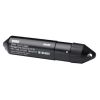
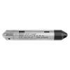
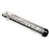
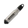
The MX20L Water Level Logger brings all the same great features as the U20L and more! Integrating Bluetooth for fast and reliable data download, the MX20L logger eliminates the need to plug your logger into a base station or shuttle to offload data in the field, ensuring continuous water level and temperature monitoring. With options to measure at depth ranges of 13, 30, or 100 feet in a wide range of underwater environments, this rugged logger features 0.1% measurement accuracy, a durable polypropylene housing for use in both freshwater and saltwater, and a non-vented design for convenient and reliable deployment.
The MX20L comes with a magnetic activation fob that can "wake up" the logger to activate its Bluetooth communication for configuration and data download. The included fob comes with a lanyard to prevent losing or dropping the fob in the field.
This logger records absolute pressure, which is later converted to water level readings by HOBOconnect software. To compensate for barometric pressure changes, another HOBO MX20L Water Level logger can be used as a barometric reference.
- Self-contained, non-vented design enables easy deployment
- Ideal for use in both freshwater and saltwater environments, including wells, streams, lakes, wetlands, and tidal areas
- Depth measurement options of up to 13, 30, or 100 feet depending on model
- Durable ceramic pressure sensor withstands freezing
- Streamlined data offload via Bluetooth to the free HOBOconnect app
- HOBOconnect app provides easy extraction and visulization of water level data
- Extended battery life up to 10 years (power-saving mode requires magnetic fob to activate Bluetooth for data download)
- (1) HOBO MX20L water level & temperature logger
- (1) HOBO magnetic activation fob
Select Options


In The News

Supplying Seattle’s Drinking Water: Using Data Buoys to Monitor the Cedar River Municipal Watershed
Providing clean, safe, and reliable drinking water for the 1.6 million people in the greater Seattle area is a top priority for Seattle Public Utilities (SPU). With limited water supplies, SPU dedicates considerable resources to maintain its watersheds and mountain reservoirs. About 70 percent of Seattle Water comes from the Cedar River Municipal Watershed , and the other 30 percent comes from the South Fork Tolt River Watershed . [caption id="attachment_39574" align="alignnone" width="940"] Data buoy in Chester Morse Lake . (Credit: Kevin Johnson / Seattle Public Utilities) [/caption] Jamie Thompson, a fisheries biologist at SPU, monitors aquatic ecosystems centered on fish listed under the U.S. Endangered Species Act (ESA).
Read More
Data-Driven Advocacy on the Lower Deschutes River
Like many freshwater environments, the Deschutes River in Oregon is under pressure from development, pollution, and climate change. Many rivers, streams and lakes in the Deschutes Basin do not meet Oregon water quality standards –where state water quality monitoring assesses levels of bacteria, pH, dissolved oxygen, temperature, and fine sediment. Hannah Camel is the Water Quality Coordinator for the Deschutes River Alliance (DRA), a non-profit organization that focuses on the health of the lower 100 miles of the Deschutes River–the area most affected by human intervention. As a data-driven organization, the DRA has benefited from the installation of two NexSens X2 data loggers.
Read More
Expanding the Port Everglades: Real-Time Monitoring of Water Quality Conditions from Planned Dredging Operation
The Port Everglades in Broward County, Florida, serves large trade vessels and cruiseliners and incoming and outgoing recreational boaters. However, as cargo ships become larger, the port must expand. A dredging project led by the US Army Corps of Engineers will substantially deepen and widen the port's navigation channel to accommodate larger Panamax cargo ships and modern cruise liners. As a result of this project, a large amount of sediment will be displaced into the water column. This suspended sediment may settle outside of the project area, burying benthic organisms like corals, and possibly carrying harmful particulates to other regions. [caption id="attachment_39497" align="aligncenter" width="2560"] A CB-950 and CB-25 deployed on site at Port Everglades.
Read More