
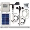
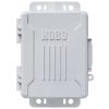
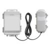
HOBO U30 USB Weather Station
Features
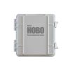
- All electronics are housed within a rugged double-weatherproof, tamper-proof enclosure
- Setup is quick and easy with plug-and-play sensors
- Includes relay that can be activated on user-defined alarm conditions
- Free ground shipping
- Expedited repair and warranty service
- Lifetime technical support
- More
Overview
The HOBO U30 USB Station is a weatherproof data logger designed for environmental monitoring applications. This rugged logger has a built-in rechargeable battery and supports up to 10 plug-and-play smart sensors and two optional analog inputs with sensor excitation. With HOBOware Pro, you can easily configure the logger, check the status, and download data for graphing and analysis. You can also use HOBOware Pro to set up a relay that can be activated on alarm conditions.
Normal operating range: -20°C to 40°C (-4°F to 104°F)
Extended operating range: -40 to 60°C (-40 to 140°F) - see "Rechargeable Battery service Life" for impact of operations in Extended Operating Range.
Sensor Inputs: 5 standard; option to expand to 10
Smart Sensor compatibility: Compatible with most HOBO smart sensors, except for the S-BPA, S-TMA and S-THA
Data channels: Maximum of 15 (some sensors use more than one data channel)
Alarm output relay: Can be configured to be activated, deactivated or pulsed on user-defined sensor alarms. The relay can be configured as normally open or normally closed, and is rated for 30 V and 1 amp max.
Expansion slot: One expansion slot is available for factory-installed expansion port.
Local communication: Full Speed USB via USB mini-B connector
Size: 17.8 H x 11.7 D x 19.3 W cm (7.0 H x 4 .6 D x 7.6 W inches)
Weight: 2 kg (4 lbs 10 oz)
Materials:
Outer enclosure: ABS blend with stainless steel hinge pins and bronze inserts
Inner enclosure: Polycarbonate with bronze inserts
U-Bolts: Steel with zinc dichromate finish
Gaskets: Silicone rubber
Cable entry channel: EPDM rubber
Cable entry bars: Aluminum with ABS plastic thumb screws
Data storage memory: Nonvolatile flash data storage, 512K bytes local storage
Memory modes: Stop when full, wrap around when full
Operational indicators: Up to six (depending upon options) status lights provide basic diagnostics
Logging interval: 1 second to 18 hours, user-specified interval
Battery type: 4 Volt, 4.5 AHr or 10 AHr, Rechargeable sealed lead-acid
Rechargeable battery service life: Typical 3–5 years depending upon conditions of use. Operation within the extended operating range (but outside the normal range) will reduce battery service life.
Time accuracy: 0 to 2 seconds for the first data point and ±5 seconds per week at 25°C (77°F)
Environmental rating: Weatherproof enclosure, tested to NEMA 6. (Requires proper installation of cable channel system)
Mounting: 3.8 cm (1.5 inch) mast or wall mount
Enclosure access: Hinged door secured by two latches with eyelets for securing with user-supplied padlocks
Sensor network cable length: 100 m (328 ft) maximum
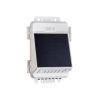
External power: External power is required. The system optionally accepts the following HOBO solar panels:SOLAR-1.2W, SOLAR-3W, SOLAR-6W. Alternatively it accepts an AC power adapter:AC-U30
Optional Analog Sensor Port Specifications
Input channels: Two, single-ended
Field wiring: Two- or three-wire via screw terminals on detachable connector, 16–24 AWG.
Replacement detachable connectors: Part of spares kit, Part No. A-FS-CVIA-7P-1
Input range: User-configurable: 0–20 mA DC, 0-2.5 VDC, 0-5 VDC, 0-10 VDC, or 0–20 VDC
Minimum/maximum input voltage: 0 / 24 VDC
Minimum/maximum input current: 0 / 24 mA DC
Minimum current source impedance: > 20 KΩ
Accuracy: ± 0.25% of FSR from 50mV to FSV
ADC resolution: 12 bits
Excitation power: Switched 12 VDC, up to 50 mA; user-selectable warm-up from 5msec to 2 minutes
- HOBO U30-NRC Station Data Logger
- Mounting kit
- Grounding wire
- Cable entry and sealing kit
Select Options


In The News

Monitoring Habitat Suitability and Water Quality in Northwest Arkansas Springs
Northwest Arkansas has seen an economic, industrial, and population boom in recent years as a result of expanding businesses, which have created thousands of jobs in the region and the mass migration of employees and construction companies. However, with this growth has come rapid urbanization and the degradation of the natural landscape, specifically the freshwater springs that can be found throughout the region. These springs are critical habitat centers for native wildlife, home to threatened and endangered fish, and those that have yet to be listed. Zach Moran, Assistant Professor of Fisheries Science at Arkansas Technical University, is working to help monitor these habitats and provide key data that will hopefully inform future development in the region.
Read More
Three Decades of Research at Acton Lake
A multi-disciplinary team at Miami University, Ohio, has been studying the environmental change at Acton Lake for over three decades. Using three different NexSens buoys over this time, the team has an incredible archive of data that is helping build a picture of Acton’s past, present, and future. Until recently, a NexSens CB-50 buoy was used alongside other environmental monitoring at Acton Lake. In May 2025, the Miami team deployed a new XB-200 buoy , future-proofing their ongoing monitoring using real-time buoy systems. Acton Lake, a small hypereutrophic reservoir in southwest Ohio, covers 2.4km² and has a maximum depth of about 8m. The dam was built in 1956, and the lake has a large agricultural watershed.
Read More
Source Water Monitoring in Albany, New York: Tracing Water Quality throughout Tributaries
Thousands of US cities pull their drinking water from natural source waters like reservoirs, rivers, and streams, making overall watershed health a key consideration for water providers. In Albany, New York, the Albany Department of Water and Water Supply delivers drinking water to over 100,000 residents as well as monitors and manages the larger drinking water supply watershed. Hannah Doherty, Environmental Specialist at the Albany Department of Water and Water Supply , spends her days working with a small team to monitor the drinking supply and the connected water bodies. Doherty explains, “We’re the first to encounter the water that ends up being the drinking water.
Read More