
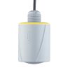
OTT RLS Radar Water Level Sensor
Features
- Transmit & receive antenna enclosed in a lightweight, durable housing with flat antenna design
- Easily mounts to a bridge, frame, pipeline, or extension arm
- Connects to NexSens X2 data logging system via SDI-12 interface
- Free ground shipping
- Expedited repair and warranty service
- Lifetime technical support
- More

Overview
The OTT RLS is a non-contact radar level sensor with pulse radar technology that is ideal for monitoring in remote areas and applications where conventional measuring systems are unsuitable. The RLS accurately and efficiently measures surface water level with a non-contact distance range of up to 115 feet above the water. The sensor is IP67 waterproof and has extremely low power consumption, making it ideal for solar-charged monitoring systems.
Revolutionary
The radar level sensor uses a revolutionary level measurement technology, meeting the USGS accuracy requirement of +/-0.01 feet. Two antennas are enclosed in a compact housing and transmit pulses toward the water surface. The time delay from transmission to receipt is proportional to the distance between the sensor and the water surface. A sampling rate of 16 Hz (16 measurements/second) with 20-second averaging minimizes water surface conditions such as waves and turbulence. The RLS does not require calibration and is unaffected by air temperature, humidity, flood events, floating debris, or contaminated water.
- (1) Radar level sensor
- (1) 2-part swivel mount
- (1) Installation kit - Includes (4) 6x40mm wood screws & (4) plastic plugs
- (2) Double open-ended wrenches (10x13)
- (1) Factory acceptance test certificate (FAT)
- (1) Operations manual
Select Options


In The News
Lake Erie Volunteer Science Network: Building Trust in Citizen Science Programs
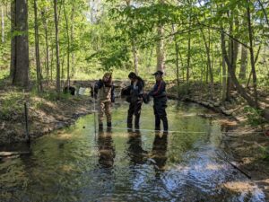
Citizen science programs have popped up across the United States, focusing on connecting local communities with nearby water resources and building a trustworthy data pool over the sampling period. While commonly utilized as a means of ensuring that large watersheds or lake regions are adequately sampled, the credibility and success of such programs have been called into question. [caption id="attachment_38996" align="alignnone" width="940"] HRWC volunteers measure stream velocity across a subsection of Woods Creek, a tributary of the Huron River near Belleville, Michigan. Stream velocity measurements can be combined with water level measurements to calculate stream flow and chemical parameter loads.
Read More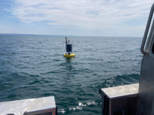
Monitoring Lake Erie’s Eastern Basin: Building Long-Term Data and Real-Time Public Solutions
In the eastern basin of Lake Erie, off the coast of Dunkirk, New York, a data buoy collects valuable water quality, weather, and wave data that inform residents and regulatory groups of conditions on the water. Since 2011, Buffalo State University’s Great Lakes Center has maintained and operated the Dunkirk buoy with funding from the Great Lakes Observing System (GLOS) and field support from the NYSDEC Lake Erie Fisheries Research Unit. [caption id="attachment_38976" align="aligncenter" width="940"] The Dunkirk Buoy viewed from the research vessel after being deployed in early spring.
Read More
SonTek CastAway-CTD Meter Review
Lightweight and easy to use, the SonTek CastAway offers a convenient 3-in-1 solution for measuring conductivity, temperature, and depth profiles. At a 5 Hz sampling rate, the CastAway is designed for up to 1 m/s free-fall through the water column. With fast response and accurate conductivity, temperature, and depth measurements, the CastAway is ideal for thermocline and halocline profiling. The unit also reports salinity and speed of sound. [caption id="attachment_38732" align="alignnone" width="940"] Environmental scientist, Katelyn Kubasky, holding the SonTek CastAway in front of the pond at the Fondriest Center for Environmental Studies.
Read More