
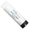
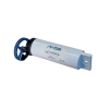
PME miniDOT Clear Dissolved Oxygen Logger
Features
- Portable, completely submersible, easy to operate
- User replaceable batteries and long lasting in the field
- Also records time, date, and battery voltage
- Expedited repair and warranty service
- Lifetime technical support
- More
Overview
The PME miniDOT Clear Dissolved Oxygen Logger is a completely submersible instrument that logs dissolved oxygen and temperature measurements with an internal LCD screen for accessing the latest readings. It includes an optical DO sensor, a temperature sensor, batteries and a micro SD memory card. Data are recorded internally with a sample interval from once per minute to once per hour and can be offloaded to a computer via USB cable.
Data Collection
The oxygen sensor is an optode that measures dissolved oxygen concentration in water through a fluorescence method. The sensing foil contains a coating that has a variable fluorescence that depends upon oxygen concentration in the surrounding water. The sensor is able to compute oxygen concentration in mg/L and record these measurements internally. Each logger is factory-calibrated at 12 oxygen concentrations, each at 8 temperatures, for a total of 96 calibration points.
Select Options


In The News

Wildfire Prevention in the Sierra Nevada Region with the Yuba Watershed Institute
Though recent wildfires have sparked new conversations about wildfire management and response, groups like the Yuba Watershed Institute have been monitoring the forests and water resources of the Sierra Nevada region for decades, managing approximately 5,000 acres of land with the Bureau of Land Management (BLM) and about 7,000 acres in private land partnerships. The goal of the Institute is to work with local communities and land agencies to improve watershed and forestry management through informed practices and public outreach. The goals of the Yuba Watershed Institute are three-fold: Improve the ability of fire suppression agencies like the California Department of Forestry and Fire Protection ( CAL FIRE ) and the US Forest Service.
Read More
Wave Sensors Integration with NexSens Buoys: A Cutting-Edge Solution for Wave Measurment
Real-time wave data supports accurate weather prediction, safe and efficient maritime operations, and provides valuable safety and operating condition information for recreation and commercial fishing. Understanding wave dynamics also helps with the design of protective coastal structures like seawalls, breakwaters, and jetties. It also supports better prediction of their impact on sediment transport and coastal geomorphology. Wave data is a key factor in qualifying and designing offshore wind farms and harnessing kinetic energy for electrical generation. It helps with the understanding of ocean-atmosphere interactions and contributes to studies of sea-level rise and climate change impacts.
Read More
Spring 2025 Environmental Monitor Available Now
In the Spring 2025 edition of the Environmental Monitor, we highlight partnerships across the world and the importance of collaboration between government agencies, universities, environmental groups, local communities, and other stakeholders. From great white shark research in Cape Cod to monitoring fisheries in Lake Erie, this latest edition underscores partnerships that connect stakeholders in a watershed through environmental data. With an emphasis on data sharing, a combination of real-time and discrete sampling keeps the public and partners informed of environmental conditions. Our writers also sought out science professionals dedicated to working with peers within and outside of the environmental sector.
Read More