
PME miniWIPER for miniPAR Logger
Features
- Completely submersible to 25m depths
- Can operate for up to 3-months at 1-hour wipe interval
- Software is supplied to change the wiping interval and check battery voltage
- Expedited repair and warranty service
- Lifetime technical support
- More
Overview
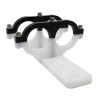
The PME miniWIPER is a self-contained, completely submersible wiping device that can be used with a variety of sensors, including the miniPAR Logger. It can be programmed to wipe at various intervals and is powered by two AA Lithium batteries. A small brush rotates over the sensor in order to perform a complete wipe of the sensor surface and then rests away from the sensor to allow for accurate and continuous monitoring. The wiper is used as an anti-fouling device and prevents various organisms from growing on the sensor and interfering with data.
Connectivity
The miniWIPER consists of the wiper motor and USB communication cable. The PME miniWIPER connects to a Windows HOST computer via USB and appears as a Local Disk. The PME miniWIPER records various parameters each time it performs a wipe which appears as files on this local disk.
Select Options


In The News

Save our Bogs! Culture, Conservation and Climate Action in Ireland’s Peatlands
Characterized by long-term accumulation under waterlogged conditions, peatlands exist on every continent and account for 3-4% of the global land surface . Small but mighty, these often overlooked wetland environments are estimated to hold as much as one-third of the world's organic carbon in their soil—twice the amount found in the entirety of the Earth's forest biomass. While healthy peatlands can trap and store carbon, regulate water, and provide important habitats for rare species, human alteration has disturbed peatland carbon and nitrogen cycles on a global scale. Approximately 12% of the world’s peatlands have been drained and degraded through conversion for agriculture, forestry, infrastructure development, and other uses.
Read More
Sargassum Surge: How Seaweed is Transforming our Oceans and Coastal Ecosystems
Until recently, Sargassum –a free-floating seaweed–was distributed throughout the Sargasso Sea , the north Caribbean Sea, and the Gulf of Mexico. But in the space of a decade, this seaweed has, as one scientist remarks , “Gone from a nonfactor to the source of a terrible crisis.” Driven by climate change, anomalous North Atlantic Oscillation in 2009-2010 and a glut of anthropogenic pollutants, sargassum has proliferated. Seasonally recurrent mats as deep as 7m now bloom in the “Great Atlantic Sargassum Belt” (GASB), which covers areas of the Atlantic from West Africa to the Caribbean Sea and Gulf of Mexico. Every year, millions of tons wash up along the shores of more than 30 countries . Dr.
Read More
Great Lakes Research Center: Designing Targeted Monitoring Solutions
According to the National Oceanic and Atmospheric Administration ( NOAA ), the Great Lakes have more miles of coastline than the contiguous Atlantic and Pacific coasts combined and contain 20 percent of the world's freshwater, making it a critical region to protect and conserve. Continuous monitoring and data-informed resource management are key components of managing waters in the region. Hayden Henderson, a research engineer with the Great Lakes Research Center (GLRC), designs and deploys monitoring platforms throughout the Great Lakes. With a background in environmental engineering, Henderson enjoyed the challenge of creating systems and making them work to obtain difficult, remote measurements.
Read More