
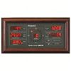
RainWise MK-III Wireless Weather Stations
Features
- Solar charged system for continuous operation
- Long range 2.4 GHz radio transmits up to 1600m
- Manufactured in the USA with 2-year standard warranty
- Free ground shipping
- Expedited repair and warranty service
- Lifetime technical support
- More
Overview
The RainWise MK-III sensor features a powerful new 2.4 GHz spread spectrum radio that Increases range to 1-mile line of sight. It also features a real-time 2-second wind speed and direction update interval. An 18” Mounting Mast is included with purchase.
Easy-to-Install
The MKlll-LR is a wireless, solar-powered weather station providing the best accuracy of any consumer weather station on the market. This compact, rugged and elegantly designed unit comes fully assembled, providing quick and easy installation. The MKlll-LR’s lightweight and compact design makes installation quick and easy. The MKlll-LR is supplied with a detachable mast section that can be secured to an existing structure.
Benefits
- Transmission range of up to one mile
- Rapid data refresh rate of every 2 seconds
- Tipping bucket rain gauge option available
- Unique aervane design - Trademark rotary blade design eliminates freezing or breaking potential
- Utilizes an internal, contact-free magnetic system that provides constant horizontal wind tracking, leaving no mechanical parts to wear out over time and require replacement.
Select Options


In The News

Supplying Seattle’s Drinking Water: Using Data Buoys to Monitor the Cedar River Municipal Watershed
Providing clean, safe, and reliable drinking water for the 1.6 million people in the greater Seattle area is a top priority for Seattle Public Utilities (SPU). With limited water supplies, SPU dedicates considerable resources to maintain its watersheds and mountain reservoirs. About 70 percent of Seattle Water comes from the Cedar River Municipal Watershed , and the other 30 percent comes from the South Fork Tolt River Watershed . [caption id="attachment_39574" align="alignnone" width="940"] Data buoy in Chester Morse Lake . (Credit: Kevin Johnson / Seattle Public Utilities) [/caption] Jamie Thompson, a fisheries biologist at SPU, monitors aquatic ecosystems centered on fish listed under the U.S. Endangered Species Act (ESA).
Read More
Data-Driven Advocacy on the Lower Deschutes River
Like many freshwater environments, the Deschutes River in Oregon is under pressure from development, pollution, and climate change. Many rivers, streams and lakes in the Deschutes Basin do not meet Oregon water quality standards –where state water quality monitoring assesses levels of bacteria, pH, dissolved oxygen, temperature, and fine sediment. Hannah Camel is the Water Quality Coordinator for the Deschutes River Alliance (DRA), a non-profit organization that focuses on the health of the lower 100 miles of the Deschutes River–the area most affected by human intervention. As a data-driven organization, the DRA has benefited from the installation of two NexSens X2 data loggers.
Read More
Expanding the Port Everglades: Real-Time Monitoring of Water Quality Conditions from Planned Dredging Operation
The Port Everglades in Broward County, Florida, serves large trade vessels and cruiseliners and incoming and outgoing recreational boaters. However, as cargo ships become larger, the port must expand. A dredging project led by the US Army Corps of Engineers will substantially deepen and widen the port's navigation channel to accommodate larger Panamax cargo ships and modern cruise liners. As a result of this project, a large amount of sediment will be displaced into the water column. This suspended sediment may settle outside of the project area, burying benthic organisms like corals, and possibly carrying harmful particulates to other regions. [caption id="attachment_39497" align="aligncenter" width="2560"] A CB-950 and CB-25 deployed on site at Port Everglades.
Read More