
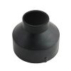
Solinst Levelogger 2" Well Cap Assembly
Features
- Simultaneously supports both Levelogger and Barologger
- Cap is secured with twist lock and accommodates 3/8" (9.5mm) shackle diameter lock
- Well cap is vented to allow for the equalization of barometric pressure in the well
- Expedited repair and warranty service
- Lifetime technical support
- More
Overview
The Solinst Model 3001 Well Cap Assembly for Leveloggers is designed to fit 2" wells (or 4" wells with Reducer), and provides options for installing Leveloggers with wireline, Kevlar rope, or using a Direct Read Cable. The well cap base provides a tight friction fit onto the well casing and is secured to the base with a twist lock. For further security, a 3/8 (9.5mm) shackle diameter lock can be used. The Well Cap is also vented to allow for the equalization of barometric pressure in the well.
Installation
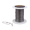
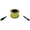
When installing Leveloggers using a Stainless Steel wireline or Kevlar rope suspension, the water level dataloggers are securely supported when tied off to the eyebolt included on the underside of the well cap insert. When installing Leveloggers using a Direct Read Cable, the cable simply fits inside the convenient well cap insert hole, when the red dust cap is removed. For Levelogger installations where a Barologger is to be installed in the same well, the well cap supports up to two Direct Read Cables. Even with the two Direct Read Cables installed, there is still an access hole available for manual water level measurements or groundwater sampling, without disturbing the down-hole Leveloggers.
Select Options


In The News

Source Water Monitoring in Albany, New York: Tracing Water Quality throughout Tributaries
Thousands of US cities pull their drinking water from natural source waters like reservoirs, rivers, and streams, making overall watershed health a key consideration for water providers. In Albany, New York, the Albany Department of Water and Water Supply delivers drinking water to over 100,000 residents as well as monitors and manages the larger drinking water supply watershed. Hannah Doherty, Environmental Specialist at the Albany Department of Water and Water Supply , spends her days working with a small team to monitor the drinking supply and the connected water bodies. Doherty explains, “We’re the first to encounter the water that ends up being the drinking water.
Read More
Wildfire Prevention in the Sierra Nevada Region with the Yuba Watershed Institute
Though recent wildfires have sparked new conversations about wildfire management and response, groups like the Yuba Watershed Institute have been monitoring the forests and water resources of the Sierra Nevada region for decades, managing approximately 5,000 acres of land with the Bureau of Land Management (BLM) and about 7,000 acres in private land partnerships. The goal of the Institute is to work with local communities and land agencies to improve watershed and forestry management through informed practices and public outreach. The goals of the Yuba Watershed Institute are three-fold: Improve the ability of fire suppression agencies like the California Department of Forestry and Fire Protection ( CAL FIRE ) and the US Forest Service.
Read More
Wave Sensors Integration with NexSens Buoys: A Cutting-Edge Solution for Wave Measurment
Real-time wave data supports accurate weather prediction, safe and efficient maritime operations, and provides valuable safety and operating condition information for recreation and commercial fishing. Understanding wave dynamics also helps with the design of protective coastal structures like seawalls, breakwaters, and jetties. It also supports better prediction of their impact on sediment transport and coastal geomorphology. Wave data is a key factor in qualifying and designing offshore wind farms and harnessing kinetic energy for electrical generation. It helps with the understanding of ocean-atmosphere interactions and contributes to studies of sea-level rise and climate change impacts.
Read More