
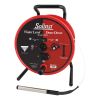
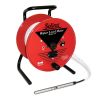
Solinst Model 101 P7 Probe Water Level Meters
Features
- Probe is submersible to 1000 ft. for measuring total well depth
- Non-stretch PVDF well tape with stainless steel conductors
- Permanent laser markings every 1/100 ft. or each millimeter
- Free ground shipping
- Expedited repair and warranty service
- Lifetime technical support
- More

Overview
The Model 101 P7 Probe Water Level Meters are the industry standard for portable hand-operated meters to measure the depth of water in wells, boreholes, standpipes, and tanks. They are sturdy, easy to use, and read accurately up to 1/100 ft. or each millimeter. The Model 101 P7 Water Level Meter features a pressure-proof probe rated at 500 psi and laser-marked PVDF tape. The P7 Probe is submersible up to 1000 ft. (300 m), ideal for measuring total well depth. The sensor at the tip of the probe provides consistent measurements with almost zero displacements. The tape seal plug design allows the probe to be quickly and easily replaced if required.
Durability
The Model 101 P7 Probe Water Level Meter uses extremely durable PVDF flat tape, traceable to NIST and EU measurement standards. Each tape conductor contains 13 strands of stainless steel, and 6 strands of copper-coated steel, making the tape non-stretch and high in tensile strength and electrical efficiency. The well tape has a thick dog bone design that prevents adherence to wet surfaces and allows it to hang straight in application settings. The tape is also easy to splice. The 3/8" (10 mm) well tapes come with permanent laser markings every 1/100 ft. or each millimeter.
- (1) Solinst Model 101 P7 Probe Water Level Meter
- (1) Tape guide/datum
Select Options


In The News

Wetland water level study skips modern sensor tangle for 1930s method
Environmental sensors can measure almost any physical parameter in nature, but sometimes they can overwhelm the science they are supposed to support. Jason Hill, an assistant professor of engineering at the University of Southern Indiana, wants to create a water level model that will help wetland restorers understand and predict water level fluctuations by studying water loss through the ground and evapotranspiration. The problem is his next project site has too many variables to measure. So, he’s taking an old fashioned route based on empiricism and water level measurement. Hill said that conventional techniques for estimating evapotranspiration require site specific micrometeorological data, like solar radiation, wind speed and vapor pressure.
Read More
Supplying Seattle’s Drinking Water: Using Data Buoys to Monitor the Cedar River Municipal Watershed
Providing clean, safe, and reliable drinking water for the 1.6 million people in the greater Seattle area is a top priority for Seattle Public Utilities (SPU). With limited water supplies, SPU dedicates considerable resources to maintain its watersheds and mountain reservoirs. About 70 percent of Seattle Water comes from the Cedar River Municipal Watershed , and the other 30 percent comes from the South Fork Tolt River Watershed . [caption id="attachment_39574" align="alignnone" width="940"] Data buoy in Chester Morse Lake . (Credit: Kevin Johnson / Seattle Public Utilities) [/caption] Jamie Thompson, a fisheries biologist at SPU, monitors aquatic ecosystems centered on fish listed under the U.S. Endangered Species Act (ESA).
Read More
Data-Driven Advocacy on the Lower Deschutes River
Like many freshwater environments, the Deschutes River in Oregon is under pressure from development, pollution, and climate change. Many rivers, streams and lakes in the Deschutes Basin do not meet Oregon water quality standards –where state water quality monitoring assesses levels of bacteria, pH, dissolved oxygen, temperature, and fine sediment. Hannah Camel is the Water Quality Coordinator for the Deschutes River Alliance (DRA), a non-profit organization that focuses on the health of the lower 100 miles of the Deschutes River–the area most affected by human intervention. As a data-driven organization, the DRA has benefited from the installation of two NexSens X2 data loggers.
Read More