
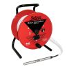
Solinst Model 101D Water Level DrawDown Meters
Features
- Both static water level and drawdown modes in one meter
- One convenient toggle makes it easy to switch between two functions
- Uses the same robust, submersible probe as the 101 P7 Water Level Meter
- Free ground shipping
- Expedited repair and warranty service
- Lifetime technical support
- More
Overview
The Solinst 101D Water Level DrawDown Meter has all of the same qualities as the well-known 101 P7 Water Level Meter, with the added feature of a drawdown mode. One simple toggle switches between static water level and drawdown measurements. Water level mode allows accurate depth to water measurements in wells, boreholes, standpipes and tanks. The drawdown function is used to monitor falling hydraulic head during low flow sampling, pumping and other aquifer/well tests. It also ensures a pump’s intake remains submerged during purging or well development.
Mechanics
The 101D Water Level DrawDown Meter uses a corrosion-resistant stainless steel probe connected to clearly marked flat tape, fitted on a well-designed reel. It is powered by a standard 9 volt battery. In water level mode, when the zero point on the probe enters water, an electronic circuit is completed, activating the buzzer and light. The depth to water is then read off the tape. In drawdown mode, the circuit is reversed—the buzzer and light are triggered when the probe is in air. The battery test button can check the circuit in both water level and drawdown modes. The on/off sensitivity control allows the buzzer to be turned down in cascading water and ensures a clear signal in high and low conductivity conditions.
- (1) Model 101D Water Level DrawDown Meter
- (1) Tape guide/datum
Select Options


In The News

Floating Global New Ideas: Buoy-Enabled Research at Florida Agricultural and Mechanical University’s School of the Environment
Florida Agricultural and Mechanical University (FAMU), based in Tallahassee, Florida, is the highest-rated public Historically Black College or University in the United States. FAMU’s School of the Environment (FAMU-SOE) offers BS and BA degrees in Environmental Studies, and BS, MS, and Ph.D. degrees in Environmental Science, with specialisms available in areas including Environmental Policy and Risk Management, Aquatic and Terrestrial Ecology, and Biomolecular Sciences. In 2021, FAMU-SOE deployed a NexSens CB-450 buoy in Apalachee Bay, a key oyster farming area around 30 miles south of Tallahassee. The buoy has quickly been incorporated into the curriculum, providing environmental insights for student research, the community, and beyond. Dr.
Read More
Monitoring Habitat Suitability and Water Quality in Northwest Arkansas Springs
Northwest Arkansas has seen an economic, industrial, and population boom in recent years as a result of expanding businesses, which have created thousands of jobs in the region and the mass migration of employees and construction companies. However, with this growth has come rapid urbanization and the degradation of the natural landscape, specifically the freshwater springs that can be found throughout the region. These springs are critical habitat centers for native wildlife, home to threatened and endangered fish, and those that have yet to be listed. Zach Moran, Assistant Professor of Fisheries Science at Arkansas Technical University, is working to help monitor these habitats and provide key data that will hopefully inform future development in the region.
Read More
Three Decades of Research at Acton Lake
A multi-disciplinary team at Miami University, Ohio, has been studying the environmental change at Acton Lake for over three decades. Using three different NexSens buoys over this time, the team has an incredible archive of data that is helping build a picture of Acton’s past, present, and future. Until recently, a NexSens CB-50 buoy was used alongside other environmental monitoring at Acton Lake. In May 2025, the Miami team deployed a new XB-200 buoy , future-proofing their ongoing monitoring using real-time buoy systems. Acton Lake, a small hypereutrophic reservoir in southwest Ohio, covers 2.4km² and has a maximum depth of about 8m. The dam was built in 1956, and the lake has a large agricultural watershed.
Read More