
Solinst Model 103 Flat Tape Tag Lines
Features
- Markings are laser etched every 1/100 ft or each mm
- Standard tag weight measures 1.5 lbs and is 3/4" x 12" (included)
- Includes tape guide to protect the tape from damage on rough edges
- Free ground shipping
- Expedited repair and warranty service
- Lifetime technical support
- More

Overview
The Solinst Tag Line uses a weight attached to a laser-marked flat tape and is principally designed for use during the installation of monitoring wells. The Tag Line also provides a simple method to measure the depth to the bottom of a well. It is also ideal as a multipurpose marked support cable.
Design
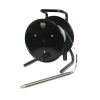
The Model 103 Flat Tape Tag Line uses a 3/8" (10 mm) PVDF flat tape. The tape has a break strength of greater than 220 lbs (100 kg). It has a thick dog bone design that prevents adherence to wet surfaces and allows it to hang straight. The well tape comes with laser markings every 1/100 ft. or each millimeter. Lengths are 100 ft to 1000 ft. (30 m to 300 m).
The standard stainless steel tag weight is 1.5 lbs (0.68 kg) and measures 3/4" x 1 ft. (19 mm x 30 cm). A narrow tag weight, 1/2" x 1 ft. (13 mm x 30 cm), weighing 0.65 lbs (0.30 kg), is also an option. Tag weights have tapered ends to minimize hang-ups during deployment and return to the surface and can be clipped on and off the tape. This allows the use of the reel-mounted marked well tape for other uses, such as bailer or pump, and packer deployment.
- (1) Solinst Model 103 Tag line mounted on reel
- (1) 3/4" x 1' tag weight
- (1) Tape guide
Select Options


In The News

New map shows significant groundwater depletion in Central California
Groundwater level data collected by a Central California county shows significant drops during the past 12 years, according to a San Luis Obispo Tribune article. Data shows that groundwater has dropped by a minimum of 70 feet from 1997 to 2009 in the Paso Robles area of Central California. In the past four years the areas of most significant decline have expanded north and south. Drought and agricultural withdrawals are the likely culprits for the groundwater decline. Some advocates are calling for more responsible water use by vineyards in the area, while farmers note that the recent drought did not help the situation.
Read More
Wildfire Prevention in the Sierra Nevada Region with the Yuba Watershed Institute
Though recent wildfires have sparked new conversations about wildfire management and response, groups like the Yuba Watershed Institute have been monitoring the forests and water resources of the Sierra Nevada region for decades, managing approximately 5,000 acres of land with the Bureau of Land Management (BLM) and about 7,000 acres in private land partnerships. The goal of the Institute is to work with local communities and land agencies to improve watershed and forestry management through informed practices and public outreach. The goals of the Yuba Watershed Institute are three-fold: Improve the ability of fire suppression agencies like the California Department of Forestry and Fire Protection ( CAL FIRE ) and the US Forest Service.
Read More
Wave Sensors Integration with NexSens Buoys: A Cutting-Edge Solution for Wave Measurment
Real-time wave data supports accurate weather prediction, safe and efficient maritime operations, and provides valuable safety and operating condition information for recreation and commercial fishing. Understanding wave dynamics also helps with the design of protective coastal structures like seawalls, breakwaters, and jetties. It also supports better prediction of their impact on sediment transport and coastal geomorphology. Wave data is a key factor in qualifying and designing offshore wind farms and harnessing kinetic energy for electrical generation. It helps with the understanding of ocean-atmosphere interactions and contributes to studies of sea-level rise and climate change impacts.
Read More