
Solinst Model 103 Wireline Tag Lines
Features
- Markings are laser etched every 1/4 foot or every 5 centimeters of the cable
- Standard tag weight measures 1.5 lbs and is 3/4" x 12" (included)
- Includes tape guide to protect the wireline from damage on rough edges
- Free ground shipping
- Expedited repair and warranty service
- Lifetime technical support
- More

Overview
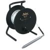
The Solinst Model 103 Wireline Tag Line uses a weight attached to a laser marked cable, and is principally designed for use during the installation of monitoring wells. The Tag Line also provides a simple method to measure the depth to the bottom of a well. It is also ideal as a multipurpose marked support cable. Markings are clearly and accurately laser etched every 1/4 foot or every 5 centimeters of the cable. The laser markings allow the cable to run smoothly over the Tape Guide.
Design
The Model 103 Wireline Tag Line uses durable polyethylene coated 1/16"" (1.6 mm) stranded stainless steel wireline with a minimum break strength of 270 lbs (122 kg). It comes in standard lengths of 100 ft. to 1000 ft. (30 m to 300 m). The cable is mounted on a sturdy free-standing reel with a carrying handle, weight holder and brake. The standard stainless steel tag weight is 1.5 lbs (0.68 kg) and measures 3/4" x 1 ft. (19 mm x 30 cm). A narrow tag weight, 1/2" x 1 ft. (13 mm x 30 cm), weighing 0.65 lbs (0.30 kg), is also an option.
Applications
Tag weights have tapered ends to minimize hang-ups during deployment and return to surface, and can be clipped on and off the cable. This allows the use of the reel-mounted marked cable for other uses, such as bailer, or pump, and packer deployment.
- (1) Solinst Model 103 Tag line mounted on reel
- (1) 3/4" x 1' tag weight
- (1) Tape guide
Select Options


In The News

New map shows significant groundwater depletion in Central California
Groundwater level data collected by a Central California county shows significant drops during the past 12 years, according to a San Luis Obispo Tribune article. Data shows that groundwater has dropped by a minimum of 70 feet from 1997 to 2009 in the Paso Robles area of Central California. In the past four years the areas of most significant decline have expanded north and south. Drought and agricultural withdrawals are the likely culprits for the groundwater decline. Some advocates are calling for more responsible water use by vineyards in the area, while farmers note that the recent drought did not help the situation.
Read More
Monitoring Mariculture in the Gulf of Alaska
The mariculture industry in the Gulf of Alaska has been steadily growing in recent years, guided by ongoing research to help refine farm location and cultivation practices. A subset of aquaculture, mariculture focuses on rearing organisms in the open ocean. In Alaska, finfish farming is illegal, so most farms cultivate kelp, oysters, or a combination of the two. These small, locally operated farms started popping up in the Gulf of Alaska in the early 1990s, when shellfish farming first became legal. Kelp farming did not begin to catch on in the state until 2016. Many of the coastal areas that have grown interested in mariculture are historically commercial fishing communities.
Read More
Supplying Seattle’s Drinking Water: Using Data Buoys to Monitor the Cedar River Municipal Watershed
Providing clean, safe, and reliable drinking water for the 1.6 million people in the greater Seattle area is a top priority for Seattle Public Utilities (SPU). With limited water supplies, SPU dedicates considerable resources to maintain its watersheds and mountain reservoirs. About 70 percent of Seattle Water comes from the Cedar River Municipal Watershed , and the other 30 percent comes from the South Fork Tolt River Watershed . [caption id="attachment_39574" align="alignnone" width="940"] Data buoy in Chester Morse Lake . (Credit: Kevin Johnson / Seattle Public Utilities) [/caption] Jamie Thompson, a fisheries biologist at SPU, monitors aquatic ecosystems centered on fish listed under the U.S. Endangered Species Act (ESA).
Read More