
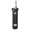
Solinst SolSat 5 Satellite Telemetry System
Features
- Global connectivity with Iridium satellite technology
- Compact and weatherproof housing for deployment in any environment
- Reports barometrically compensated water level data
- Free ground shipping
- Expedited repair and warranty service
- Lifetime technical support
- More
SolSat 5 Satellite Telemetry is an advanced telemetry system that leverages Iridium satellite technology to provide global connectivity for remote water monitoring projects. The SolSat 5 is simple to set up with Solinst dataloggers using an integral, secure Wi-Fi App on your smartphone.
SolSat 5 combines intelligent electronics with built-in sensors, alarm capabilities, and storage for up to 100,000 readings, allowing efficient satellite transmissions and power usage while providing high data integrity.
The SolSat 5 is compact, lightweight, and features a robust weatherproof enclosure. SolSat 5 is deployed anywhere with very little site preparation, saving costs and time in the field. A built-in solar panel extends the battery life, and you can easily add a second panel.
SolSat 5 Satellite Telemetry connects to one Solinst datalogger. The built-in barometric sensor allows for automatically compensated water level data reported from the field. Along with water level, temperature, conductivity, and barometric data, battery voltage from the remote SolSat 5 is received with each data report.
- Communication: 9603 Iridium SBD Satellite Modem
- Communication Distance: Global coverage (*clear view to the sky required for best performance and battery life)
- Antenna: High-performance helical (SMA connector)
- Data File Type: Sent via SMS, export as .csv or .xle
- Sampling Interval: Hourly
- Reporting Interval: Daily, every 6 hours, or hourly
- Schedule Programming: Wi-Fi App (browser) on your smart device or laptop
- Power Supply: 2 x 3.4 Ah LiPo batteries
- Battery Charging: USB 5 volts, built-in 2 Watt 325 mAh solar panel, optional additional solar panel
- Battery Life Estimate: 2–3 years* (based on hourly samples and one satellite transmission per day)
- Memory Capacity: 100,000 readings (wrap-around memory)
- Operating Temperature: -20ºC to +55ºC
- Weight: 535 grams (18.9 ounces)
- Size: 19.1 cm x 16.4 cm x 6.4 cm (7.5" x 6.5" x 2.5")
- IP Rating: IP66
- Compatible Dataloggers: Levelogger 5, Barologger 5, Levelogger 5 Junior, Levelogger 5 LTC, LevelVent 5
- Connected Dataloggers: 1
- Barometric Compensation: Internal barometer for automatic barometric compensation of water level data if a Barologger is not being used (not required for vented loggers)
- Internal Barometer Range: 30 kPa – 110 kPa
- Internal Barometer Accuracy: ±0.1 kPa (1 cm)
- Warranty: 1 Year
Select Options


In The News

Source Water Monitoring in Albany, New York: Tracing Water Quality throughout Tributaries
Thousands of US cities pull their drinking water from natural source waters like reservoirs, rivers, and streams, making overall watershed health a key consideration for water providers. In Albany, New York, the Albany Department of Water and Water Supply delivers drinking water to over 100,000 residents as well as monitors and manages the larger drinking water supply watershed. Hannah Doherty, Environmental Specialist at the Albany Department of Water and Water Supply , spends her days working with a small team to monitor the drinking supply and the connected water bodies. Doherty explains, “We’re the first to encounter the water that ends up being the drinking water.
Read More
Wildfire Prevention in the Sierra Nevada Region with the Yuba Watershed Institute
Though recent wildfires have sparked new conversations about wildfire management and response, groups like the Yuba Watershed Institute have been monitoring the forests and water resources of the Sierra Nevada region for decades, managing approximately 5,000 acres of land with the Bureau of Land Management (BLM) and about 7,000 acres in private land partnerships. The goal of the Institute is to work with local communities and land agencies to improve watershed and forestry management through informed practices and public outreach. The goals of the Yuba Watershed Institute are three-fold: Improve the ability of fire suppression agencies like the California Department of Forestry and Fire Protection ( CAL FIRE ) and the US Forest Service.
Read More
Wave Sensors Integration with NexSens Buoys: A Cutting-Edge Solution for Wave Measurment
Real-time wave data supports accurate weather prediction, safe and efficient maritime operations, and provides valuable safety and operating condition information for recreation and commercial fishing. Understanding wave dynamics also helps with the design of protective coastal structures like seawalls, breakwaters, and jetties. It also supports better prediction of their impact on sediment transport and coastal geomorphology. Wave data is a key factor in qualifying and designing offshore wind farms and harnessing kinetic energy for electrical generation. It helps with the understanding of ocean-atmosphere interactions and contributes to studies of sea-level rise and climate change impacts.
Read More