
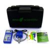
Solinst Sonic Water Level Meter
Features
- Accurately measure water levels down to 600m (2000 ft.)
- Works in any closed pipe, straight or angled
- Supplied with a plastic cover/disk for larger wells and a convenient field bag
- Free ground shipping
- Expedited repair and warranty service
- Lifetime technical support
- More
Overview
The Solinst Sonic Water Level Meter is a portable, acoustic ranging instrument designed to simply and quickly measure depth to static water level in a well, piezometer, sounding tube, or any closed pipe. The Sonic Water Level Meter reports static water level measurements without having to put any instruments down the well, eliminating any introduction of chemicals and the need to decontaminate equipment or wells. The Solinst Sonic Water Level Meter works in straight or crooked pipes, and is ideal for wells with difficult access. Depth measurements to 600 m (2000 ft) are possible.
Installation
The Solinst Sonic Water Level Meter consists of a Control Unit and connected Probe. The Control Unit has a clear LCD display, keypad, and comes with 6 AA replaceable batteries. The Control Unit keypad has buttons to turn the Probe on and off, read the depth to water, and controls to scroll through and set other parameters. The Probe connects to the Control Unit with a 1.8 m (6 ft) cable. The Sonic Water Level Meter Probe is designed to sit in the vent opening of a standard well cap, or the opening in a Solinst 2" Locking Well Cap.
- Control Unit Dimensions: 19 x 9 x 4 cm (3.5 x 7.5 x 1.5")
- Control Unit Weight: 390 g (14 oz)
- Probe Dimensions: 16 x 8 x 7 cm (6 x 3 x 3")
- Probe Diameter: 1.7 cm (5/8")
- Cable Length: 1.8 m (6 ft)
- Operating Temperature: -20 to 45ºC (-10 to 110ºF)
- Power: 6 AA replaceable alkaline batteries
- Battery Life: Up to 500 hours of use; Up to 21 days in power save mode
- Units of Measurement: Metric or English options
- Accuracy: 3 cm (0.1 ft)
- Resolution: 1 cm (0.05 ft)
- Water Level Reading Update Time: ~ 1 sec @ 150 m (500 ft); ~ 4 sec @ 600 m (2000 ft)
- Operating Range: 3 to 600 m (9 to 2000 ft)
- (1) Sonic water level meter readout
- (1) Sonic water level meter probe
- (1) Plastic disk for larger wells
- (1) Field bag
Select Options


In The News

Monitoring Mariculture in the Gulf of Alaska
The mariculture industry in the Gulf of Alaska has been steadily growing in recent years, guided by ongoing research to help refine farm location and cultivation practices. A subset of aquaculture, mariculture focuses on rearing organisms in the open ocean. In Alaska, finfish farming is illegal, so most farms cultivate kelp, oysters, or a combination of the two. These small, locally operated farms started popping up in the Gulf of Alaska in the early 1990s, when shellfish farming first became legal. Kelp farming did not begin to catch on in the state until 2016. Many of the coastal areas that have grown interested in mariculture are historically commercial fishing communities.
Read More
Supplying Seattle’s Drinking Water: Using Data Buoys to Monitor the Cedar River Municipal Watershed
Providing clean, safe, and reliable drinking water for the 1.6 million people in the greater Seattle area is a top priority for Seattle Public Utilities (SPU). With limited water supplies, SPU dedicates considerable resources to maintain its watersheds and mountain reservoirs. About 70 percent of Seattle Water comes from the Cedar River Municipal Watershed , and the other 30 percent comes from the South Fork Tolt River Watershed . [caption id="attachment_39574" align="alignnone" width="940"] Data buoy in Chester Morse Lake . (Credit: Kevin Johnson / Seattle Public Utilities) [/caption] Jamie Thompson, a fisheries biologist at SPU, monitors aquatic ecosystems centered on fish listed under the U.S. Endangered Species Act (ESA).
Read More
Data-Driven Advocacy on the Lower Deschutes River
Like many freshwater environments, the Deschutes River in Oregon is under pressure from development, pollution, and climate change. Many rivers, streams and lakes in the Deschutes Basin do not meet Oregon water quality standards –where state water quality monitoring assesses levels of bacteria, pH, dissolved oxygen, temperature, and fine sediment. Hannah Camel is the Water Quality Coordinator for the Deschutes River Alliance (DRA), a non-profit organization that focuses on the health of the lower 100 miles of the Deschutes River–the area most affected by human intervention. As a data-driven organization, the DRA has benefited from the installation of two NexSens X2 data loggers.
Read More