
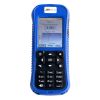
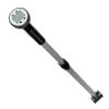
SonTek FlowTracker2 Handheld ADV
Features
- Improved ADV acoustics: faster pinging, lower noise and better standard error
- Embedded GPS for geo-referencing with automatic or manual fixes
- Set up and save templates—no need to re-enter data every time you visit a site
- Expedited repair and warranty service
- Lifetime technical support
- More
Overview
The SonTek FlowTracker2 (FT2) handheld Acoustic Doppler Velocimeter (ADV) is a wading discharge measurement instrument that is handheld, portable and precise. 2-D data in the horizontal plane (2D/3D option available) allows the most comprehensive QC and understanding about flow conditions. User calibration is never required.
Benefits
- Embedded GPS for georeferencing with automatic or manual fixes
- Improved ADV acoustics: faster pinging, lower noise and better standard error
- Battery life icon on the screen at all times. Pre-load the spare cartridge and replace, even mid-measurement, with no data loss
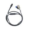
- Detachable probe with extension cables to customize cable length up to 10m
- Probes and handhelds are interchangeable—flexibility within agency teams and when sending equipment for service
- Set up and save templates—no need to re-enter data every time you visit a site
- Bluetooth or direct USB interface with PC
- Audio prompts
Handheld Specifications
| Input Battery Voltage | 8 - 12 VDC |
| Power Supply | 8 X AA Batteries |
| Battery Life | 11 hours continuous use, typical settings1 |
| Power Consumption | 1 W (Average) |
| GPS: H. Position Accuracy | Up to 2.5 m (8.2 ft) nominal2 |
| GPS: Frequency | L1 (1.575 MHz) SBAS compensation (WAAS, EGNOS, MSAS, GAGAN) |
| LCD Resolution | 320 X 240 TFT Transmissive |
| Bluetooth | Class 2, Range = 10 m (33 ft) nominal |
| USB | Micro USB, IP-67 |
| Battery Power to Probe | 8 - 12 VDC |
| Data Transfer | RS-232 |
| Data Storage | 16 GB. Up to 10k discharge measurements Up to 10 million velocity samples |
| Operating Temperature | Alkaline Batteries: -20° to 45°C (-4°F to 113°F) NiMH: -20° to 50°C (-4°F to 122°F) |
| Storage Temperature | -30° to 70° C (-22° F to 158° F)3 |
| Waterproof Rating | IP-67 (1m submersible) |
| Handheld Dimensions | (L)10.4 cm (4.1 in) (W) 6.4 cm (2.5 in) (H) 23.7cm (9.3 in) |
| Weight in Air | 0.75 kg (1.65 lbs) |
| Weight in Water | -0.25 kg (-0.55 lbs) |
Probe Specifications
| Velocity Range | ±0.001 to 4.0 m/s (0.003 to 13 ft/s) |
| Velocity Resolution | 0.0001 m/s (0.0003 ft/s) |
| Velocity Accuracy | +/1% of measured velocity, +/- 0.25cm/s |
| Acoustic Frequency | 10.0 MHz |
| Sampling Volume Location | 10 cm (3.93 in) from the center transducer |
| Minimum Depth | 0.02 m (0.79 in) |
| Depth Measurement Range | 0 to 10m (0 to 32.81ft) |
| Depth Measurement Resolution | 0.001m (0.003ft) |
| Depth Sensor Accuracy | +/- 0.1% of FS (temperature compensated over full operating range) |
| +/- 0.05% Static (steady-state at 25°C) | |
| Additionally compensated for real-time water velocity, temperature, salinity, and altitude. |
|
| Temperature Sensor | Resolution: 0.01° C, Accuracy: 0.1° C |
| Tilt Sensor | Resolution: 0.001°, Accuracy: 1.0° |
| Communication Protocol | RS-232 |
| Operating/Storage Temperature | -20° C to 50° C (-4° F to 122° F) |
| Probe Head Dimensions | (L)13.3 cm (5.22 in) (W) 6.1 cm (2.39 in) (H) 2.3 cm (0.90 in) |
| Standard Cable Length | 1.5 m (4.92 ft) |
| Weight in Air | 0.90 kg (1.98 lbs) |
| Weight in Water | 0.30 kg (0.66 lbs) |
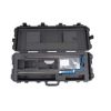
- (1) FlowTracker2 handheld display unit
- (1) USB interface cable
- (1) Spare battery cartridge
- (8) AA alkaline batteries
- (1) Shipping case
Select Options


In The News

Data-Driven Advocacy on the Lower Deschutes River
Like many freshwater environments, the Deschutes River in Oregon is under pressure from development, pollution, and climate change. Many rivers, streams and lakes in the Deschutes Basin do not meet Oregon water quality standards –where state water quality monitoring assesses levels of bacteria, pH, dissolved oxygen, temperature, and fine sediment. Hannah Camel is the Water Quality Coordinator for the Deschutes River Alliance (DRA), a non-profit organization that focuses on the health of the lower 100 miles of the Deschutes River–the area most affected by human intervention. As a data-driven organization, the DRA has benefited from the installation of two NexSens X2 data loggers.
Read More
Expanding the Port Everglades: Real-Time Monitoring of Water Quality Conditions from Planned Dredging Operation
The Port Everglades in Broward County, Florida, serves large trade vessels and cruiseliners and incoming and outgoing recreational boaters. However, as cargo ships become larger, the port must expand. A dredging project led by the US Army Corps of Engineers will substantially deepen and widen the port's navigation channel to accommodate larger Panamax cargo ships and modern cruise liners. As a result of this project, a large amount of sediment will be displaced into the water column. This suspended sediment may settle outside of the project area, burying benthic organisms like corals, and possibly carrying harmful particulates to other regions. [caption id="attachment_39497" align="aligncenter" width="2560"] A CB-950 and CB-25 deployed on site at Port Everglades.
Read More
It’s Time to React to Water Quality: Proteus Multiparameter Probe aboard NexSens Buoy
Water quality monitoring is essential for safeguarding public health, protecting ecosystems, and ensuring the sustainability of water resources. Contaminants such as industrial pollutants, agricultural runoff, and sewage discharge can severely impact aquatic life and pose serious risks to human health if left unchecked. Traditionally, water quality monitoring has been a slow and labor-intensive process, requiring samples to be collected, transported to a lab, and analyzed—a process that can take days. However, with the advancement of real-time sensor technology, environmental agencies, researchers, and industries can now monitor water quality instantly.
Read More