
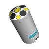
SonTek Hydroboard II Max Floating Platform
Features
- Fits the RiverSurveyor S5/M9 and HydroSurveyor systems
- Compatible with SonTek GPS and PCM solutions
- Suitable for discharge measurements in water velocities up to 5 m/s
- Expedited repair and warranty service
- Lifetime technical support
- More
Innovative
Face the challenge of high velocity discharge measurements with the confidence gained from using the SonTek HydroBoard II. The dive-resistant, flexible body design allows the HydroBoard II to be used anywhere from low velocity irrigation canals to high-velocity mountain streams.
Rugged
Specifically designed with the full forces of nature in mind, the HydroBoard II uses a highly buoyant, closed-cell foam and secure mounting hardware for the RiverSurveyor and HydroSurveyor ADP systems, and bright fluorescent laminate for high visibility in larger bodies of water.
Stable
One of the greatest sources of error in an ADP discharge measurement is excessive and irregular speed. This sleek and sturdy design provides the user with the platform to achieve the controlled speed and tracking conducive to quality ADP discharge measurements.
Select Options

In The News

Data-Driven Advocacy on the Lower Deschutes River
Like many freshwater environments, the Deschutes River in Oregon is under pressure from development, pollution, and climate change. Many rivers, streams and lakes in the Deschutes Basin do not meet Oregon water quality standards –where state water quality monitoring assesses levels of bacteria, pH, dissolved oxygen, temperature, and fine sediment. Hannah Camel is the Water Quality Coordinator for the Deschutes River Alliance (DRA), a non-profit organization that focuses on the health of the lower 100 miles of the Deschutes River–the area most affected by human intervention. As a data-driven organization, the DRA has benefited from the installation of two NexSens X2 data loggers.
Read More
Expanding the Port Everglades: Real-Time Monitoring of Water Quality Conditions from Planned Dredging Operation
The Port Everglades in Broward County, Florida, serves large trade vessels and cruiseliners and incoming and outgoing recreational boaters. However, as cargo ships become larger, the port must expand. A dredging project led by the US Army Corps of Engineers will substantially deepen and widen the port's navigation channel to accommodate larger Panamax cargo ships and modern cruise liners. As a result of this project, a large amount of sediment will be displaced into the water column. This suspended sediment may settle outside of the project area, burying benthic organisms like corals, and possibly carrying harmful particulates to other regions. [caption id="attachment_39497" align="aligncenter" width="2560"] A CB-950 and CB-25 deployed on site at Port Everglades.
Read More
It’s Time to React to Water Quality: Proteus Multiparameter Probe aboard NexSens Buoy
Water quality monitoring is essential for safeguarding public health, protecting ecosystems, and ensuring the sustainability of water resources. Contaminants such as industrial pollutants, agricultural runoff, and sewage discharge can severely impact aquatic life and pose serious risks to human health if left unchecked. Traditionally, water quality monitoring has been a slow and labor-intensive process, requiring samples to be collected, transported to a lab, and analyzed—a process that can take days. However, with the advancement of real-time sensor technology, environmental agencies, researchers, and industries can now monitor water quality instantly.
Read More