
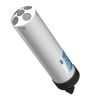
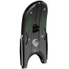
SonTek M9 Acoustic Doppler Profiler
Features
- Highly accurate measurements from 0.06m to 40m depths
- Vertical acoustic beam for superior, highly accurate channel definition
- All discharge computations performed internally - no lost data from communication loss
- Expedited repair and warranty service
- Lifetime technical support
- More
Overview
Introducing the SonTek M9: the ultimate solution for both discharge data and bathymetric surveys. Combining the durability of the RiverSurveyor-M9 with the adaptability of the HydroSurveyor-M9, this all-in-one ADCP offers unmatched flexibility. Designed to excel in various conditions, from floods to dry spells, it eliminates complicated adjustments with automatic handling. Revolutionizing river and canal measurements, the M9 delivers exceptional performance, including velocity mapping and bathymetric surveys. Pair it with HYPACK Environmental Mapping software for a comprehensive solution in a single system.
Technology
The SonTek M9 stands as the trusted choice for leading environmental water monitoring agencies globally, setting new standards in the ADCP industry. It earns its accolades as the pioneer ADCP utilizing multiple frequencies, powered by SonTek's exclusive SmartPulseHD technology. This groundbreaking innovation ensures consistently accurate measurements across various depths, from shallow to deep waters, solidifying its reputation for reliability.
|
Profiling Range — Distance |
0.06 to 40m |
| Profiling Range — Velocity | ±20 m/s |
| Velocity — Accuracy | ±0.25% of measured velocity ±0.2cm/s |
| Velocity — Resolution | 0.001 m/s |
| Number of Cells | Up to 128 |
| Cell Size | 0.02 to 4m |
| Transducer Configuration | Nine (9) Transducers |
| Dual 4-beam 3.0 MHz/1.0 MHz Janus 25° Slant Angle |
|
| 0.5 MHz Vertical Beam Echosounder | |
| Depth — Range | 0.20 to 80m |
| Depth — Accuracy | 1% |
| Depth — Resolution | 0.001 m |
| Discharge Measurement Range — Bottom-Track | 0.3 to 40m |
| Discharge Measurement Range — RTK GPS | 0.3 to 80 m |
| Discharge Measurement — Computations | Internal |
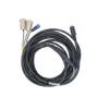
- M9 acoustic Doppler current profiler
- Power supply
- Shipping case
Select Options


In The News
Monitoring Kentucky’s Water Resources with Drone Imaging and Unmanned Surface Vehicles
Wesley Turner, an Environmental Scientist Advisor with the GIS and Data Analysis Section of the Watershed Management Branch in the Kentucky Division of Water , spends his days researching current technology and developing various drone programs for the Division of Water. Having grown up during Love Canal and Valley of the Drums, Turner decided at a young age that he wanted to become a scientist and spend his life trying to right humanity’s wrongs and protect the environment. “I loved looking at the plants and animals on the farm where I lived. I wondered at the beauty and mystery of the soil and water in the surrounding fields. As I grew older, I learned of the problems our species caused on the planet […] I remember thinking things had to change,” recalls Turner.
Read More
Eyes on Ohio Waters: Water Quality Monitoring in the Huntington District
The world of water quality monitoring is vast and diverse, with environmental professionals working in the field in a variety of environments and applications. From watershed monitoring to source water management , a career in water quality provides opportunities worldwide. Thaddaeus Tuggle chose to pursue a career in water quality after attending Cedarville University and working closely with the environmental faculty, who instilled in him a passion for working in streams, improving water quality, and educating people about the overall importance of watershed stewardship. After graduating, Tuggle worked for the Knox Soil & Water Conservation District in central Ohio before eventually returning to Marshall University in West Virginia.
Read More
Spring 2025 Environmental Monitor Available Now
In the Spring 2025 edition of the Environmental Monitor, we highlight partnerships across the world and the importance of collaboration between government agencies, universities, environmental groups, local communities, and other stakeholders. From great white shark research in Cape Cod to monitoring fisheries in Lake Erie, this latest edition underscores partnerships that connect stakeholders in a watershed through environmental data. With an emphasis on data sharing, a combination of real-time and discrete sampling keeps the public and partners informed of environmental conditions. Our writers also sought out science professionals dedicated to working with peers within and outside of the environmental sector.
Read More